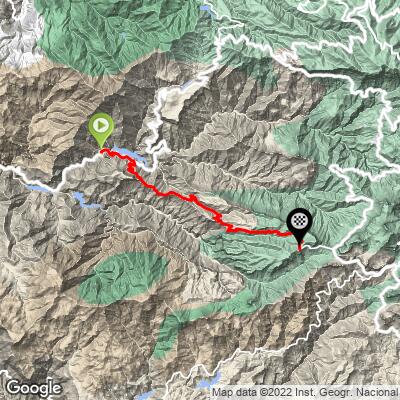
Valley of the Tears Bike Climb - PJAMM Cycling

28.5
PDI
12.8 mi
DISTANCE
4,728 ft
GAINED
6.2 %
AVG. GRADE

FULL CLIMB STATS

Page Contributor(s): Lisa Irizarry and Matthew Jiang, New York, New York; Luke Hise, Phoenix, AZ

INTRO

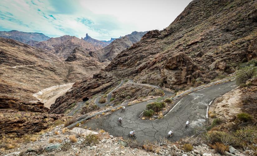
The Valley of the Tears is a legendary climb that tests even the strongest pro cyclists with brutal gradients and relentless switchbacks. The desolate, otherworldly landscape makes you feel like you're riding on Mars, with sweeping views that are as humbling as they are breathtaking. Every pedal stroke up this beast earns you serious bragging rights—it's not just a climb, it’s a rite of passage for anyone riding on Gran Canaria. 

Like the name says, it will make you cry.

PLAN YOUR ROUTE

We've partnered with Sherpa-Map.com to bring you the best route planning tool. With a PRO Membership you can use this climb as a reference when creating your route.

See more details and tools regarding this climb's grade via our interactive Profile Tool.
Traffic:
Traffic along the Valley of the Tears is very light, with extremely few cars driving very slow to enjoy the scenery

Roadway:
The road conditions can be challenging, with sections of extremely poor pavement quality, especially on the GC-606 segment - in fact, this might be the worst pavement on the entire island, almost everywhere else being a cyclist's dream. While there, we saw as many riders on mountain and gravel bikes as we did on road bikes. Descending this road is especially bumpy. 


There is nothing after you exit the main town of La Aldea de San Nicolas de Tolentino. 
Before heading out on any cycling adventure check out our Things to Bring on a Cycling Trip and use our interactive check list to ensure you don't forget anything.
See our Gran Canaria climb zone page for info on traveling to cycle on the island.

ROUTE MAP

MEMBER RATING

Not Yet Rated
-
Road
-
Traffic
-
Scenery

CURRENT WEATHER

PJAMM TRIPS ADVENTURE STARTER BUNDLES

Check out PJAMM Adventure's prepackaged (self-guided) cycling trips. They will help you plan, document and conquer your next adventure.
ALL TRIPS
Browse all of our prepackaged trips and find your next adventure!
Gran Canaria
Spain
17 ROUTES
10 POIs
ROUTE STATS (TOTAL)
215.8
mi
DISTANCE
61,983
ft
ELEV. GAIN
Tenerife
Spain
16 ROUTES
18 POIs
ROUTE STATS (TOTAL)
357.2
mi
DISTANCE
95,674
ft
ELEV. GAIN

NEARBY CLIMBS (0) RADIAL PROXIMITY

FROM
No Climbs Found

MEMBER REVIEWS & COMMENTS

Let us know what you thought of this climb. Signup for our FREE membership to write a review or post a comment.
Already have an account?
ROUTE MAP
PROFILE TOOL
Route Data
S.G. (%)
hide
Segment Data
hide
CLIMB SUMMARY

Valley of the Tears

Cycling the Valley of the Tears, Gran Canaria, Canary Islands

Ride 12.6 kilometers gaining 1,070 meters at 8.4% average grade (9.1% climb only).

The Valley of the Tears certainly lives up to its name. This is the most feared and famous climb on the island of Gran Canaria, and a must-do if you go there to ride, even though it’s a sufferfest. Bad pavement, frequent 15-20% inclines make this an extremely difficult ascent, yet is one of the most remarkable roads we’ve ever ridden.

The entrance to the valley is rolling, with brief steep uphills and downhills. There is plenty to eat at the town of La Aldea de San Nicolas de Tolentino, but once you head up the road there are no provisions, just an empty, peaceful canyon.

Approaching the first set of hairpins.

Photo collage shows PJAMM cyclists riding the approach to the dam at Presa del Parralillo 300 meters from the start of the climb.

The approach to the dam at Presa del Parralillo

After the dam is the first of several ridiculously steep sections, the hairpins above the tunnel. This segment is just around a mile long and rarely drops below a 10% gradient.

Pain…

Full view of this segment, the tunnel, and the right turn off onto the primary “Valley of the Tears” road to El Carrizal on the right:

The tunnel is not technically on the climb, but definitely ride over and check it out!

Riding in this direction will take you up the Mirador del Molino climb, another one of our favorites.

Truly a remarkable road.

You continue weaving across a magnificent ridgeline with epic views on both sides.

The next steepest segment is, through the town of Carrizal de Tejeda. The road briefly flattens out before you enter the town, where you’ll be greeted by 15-20% gradients.

Pain awaits…

Are you crying yet?

The view from near the end of the climb; Mount Teide of Tenerife across the ocean. The town is El Toscon, the third and final “steep” segment (it’s all steep…) No shame in walking a bit through there…

photo collage shows stunning volcanic rock formations in the mountainsides along roadway

Stunning rock formation along this minimally-traveled road. 

67 meter rock pinnacle Roque Nublo

Roque Nublo top-center of bottom photo. The 67 meter volcanic plug is visible to the east along the climb.

Valley of the Tears is a must do climb if you are here, but as all the blogs say, the pavement is not great. You can make it up on a road bike if you are careful and avoid the cracks in the road and loose gravel. I had 28mm tires and slipped a few times but was mostly fine.

narrow, one-lane mountain roadway in bad shape

Roque Nublo (third highest point on the island) as seen just past Presa del Parralillo