![]()
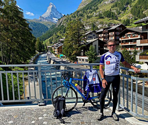
Cycling to the Matterhorn - Schwarzsee
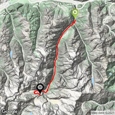
Ride 41.8 kilometers gaining 2,185 meters at 4.6% average grade (6.6% climb only).
![]()
Ride as close to the famed Matterhorn on a road bike as you can on this climb which takes us from Stalden through Zermatt to Zermatt Schwarzsee ski resort.
![]()
Climb begins in Stalden (2019 population 1,086)
Climb summary by PJAMM ambassador Ard Oostra, Montreux, Switzerland.
This 48 km long climb starts just north of Stalden. The first winding kilometers to the village and then continuing to the intersection with the Saas Fee Valley immediately show some moderate grade percentages. Once you’re on the road into the Zermatt Valley the steepness varies from light to moderate, and there are even a couple of flat and downhill sections. Near St. Niklaus is a 2.3 kilometer tunnel that cannot be taken by bike, the old parallel road needs to be used instead.
![]()
The first 20 kilometers of this climb are not particularly interesting; there can be a lot of traffic on this road and the scenery is not that fascinating. Only further up into the valley the snow covered peaks of some 4000m + mountains become visible. Approaching the village of Tasch makes you realize that here you arrive in the midst of Alpine scenery. At Tasch the motorized traffic needs to park in the huge terminals and passengers can take the shuttle train to continue to Zermatt.
![]()
Luckily, cyclists can take the 6 km road to Zermatt that is only authorized for permit holders. This is a fairly quiet road with nice scenery, partly along the river. Arriving in Zermatt over this road is interesting, the first non-touristic urban part is ugly, apart from the famous Matterhorn that becomes visible. Approaching the center, don't take the main road (shopping and restaurant street) straight into the huge crowds of tourists, instead, stay left and follow the river. Towards the end of the village take the road up to the small village of Furri. Zermatt is at 1600 m altitude, its some 350 m up to Furri. This small forest road is paved and offers the amazing views on the Matterhorn. There is not much car traffic but beware of all kind of downhill engines: MTBs, e-bikes, steps and other undefinable things on wheels offering downhill fun to tourists (of course 99% of these people take one of the cable lifts up with their vehicle. Few people cycle up. I haven’t encountered any road biker going up from Zermatt to Schwarzsee). Do be careful for hikers on the road.
![]()
Pass through Zermatt at kilometer 31
“Zermatt, in southern Switzerland’s Valais canton, is a mountain resort renowned for skiing, climbing and hiking. The town, at an elevation of around 1,600m, lies below the iconic, pyramid-shaped Matterhorn peak. Its main street, Bahnhofstrasse is lined with boutique shops, hotels and restaurants, and also has a lively après-ski scene. There are public outdoor rinks for ice-skating and curling.” Google Maps
A few kilometers beyond Furri, just after the short tunnel at the dam and lake the road turns into gravel (approximately 2000m altitude). From here on, tourist density declines gradually. Since I arrived late in the afternoon and most cable lifts close around 16-17h, I soon would have the road almost completely to myself.
![]()
Staudamm Amuttbach at kilometer 36.2
Unfortunately at around 2200 m altitude the smooth gravel turns into a rough surface with many stones and obstacles (at least for a road bike with 25 mm tires). At this point the steepness also increases. It’s only because the scenery is so stunning, the Matterhorn is impressively towering above, that the motivation remains fully intact to continue. These last four kilometers to the Schwarzsee hotel at 2560 m is a combination of cycling and pushing the bike. At around 2350 m the road is temporarily flat with some downhill. The last couple of kilometers go steep up again. Towards the end first passing the Schwarzsee on the west side with a little higher the hotel. At this time of the day (17h30) there is no living soul around anymore. Time to fully enjoy the majestic mountain scenery!
![]()
I’ve seen many passes and cols in my cycling life, but this one is “hors catégorie.” Really special: the views on the highest mountain peaks of the Swiss Alps, the eternal snow, the glaciers, the alpine vegetation and of course the Matterhorn (its summit being another 1800 m higher than Schwarzsee!!!) The cold northern wind and the time pressure (sunset around 20h30) makes me decide not to linger too long.
![]()
![]()
Finish at Schwarzsee ski station.
![]()
![]()
In summary, this ride is about 2000 m total altitude gain from Stalden, and it provides a variety of changing scenery and road conditions. Definitely recommended if you want to do it the whole way. This said, with a MTB or cross road bike it is both a nice challenging ride up from Zermatt to Schwarzsee (1000 m altitude gain). The advantage is that a strong rider can stay on the bike the whole gravel section upwards and...... downhill. 😃
Note that it should be possible -- with a MTB -- to follow the road from Schwarzsee hotel, first slightly downhill and then steep up towards the cable station at 2900 altitude (see photos taken during the second day to get an impression). For strong riders and MTBs only!
![]()
Thank you Ard!!