Socrates Mine Road Bike Climb - PJAMM Cycling

5.4
FIETS
3.5 mi
DISTANCE
1,814 ft
GAINED
9.9 %
AVG. GRADE

FULL CLIMB STATS

INTRO

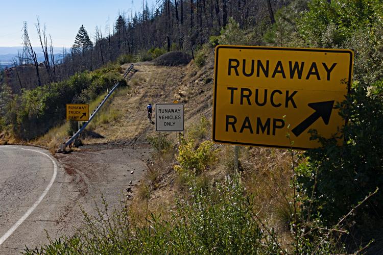
Where else will you see three runaway truck ramps on a rural three mile road??  This is the steepest paved mile in California and third steepest in the US.   
Average grade is 9.9%.   26% of the climb is at 10-15% grade, 17% at 15-20% and 5% is at an extraordinary ≥ 20%.  The steepest quarter-mile is 17.2% and steepest mile 16.3%.  

See more details and tools regarding this climb's grade via the “Profile Tool” button.
Roadway:  Two lane rural roadway with a double yellow center stripe, no shoulder, and in fair to poor condition.

Traffic:  Minimal.

Parking:  At the start of the climb or one-tenth of a mile up the road from the start (MapStreet View). 
Provisions:  Closest and best provisions are in Middletown 4.5 miles east. We recommend Beulah's Kitchen for breakfast/pastries/coffee (Map), or Perry's Deli for sandwiches (Map).  
Before heading out on any cycling adventure check out our Things to Bring on a Cycling Trip and use our interactive check list to ensure you don't forget anything.
Be sure to consider riding in Napa County and Sonoma County if you are in the area.  If you have travelled to Lake County to cycle, you are welcome to contact me at john@pjammcycling.com if you have any questions about the area - I grew up and live in nearby Sonoma County, but do have a good working knowledge of the surrounding area, including Lake County. 
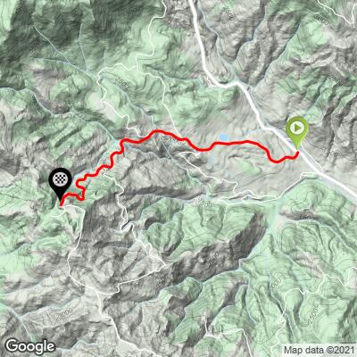
ROUTE MAP

MEMBER RATING

Not Yet Rated
-
Road
-
Traffic
-
Scenery

CURRENT WEATHER

PJAMM TRIPS ADVENTURE STARTER BUNDLES

Check out PJAMM Adventure's prepackaged (self-guided) cycling trips. They will help you plan, document and conquer your next adventure.
ALL TRIPS
Browse all of our prepackaged trips and find your next adventure!
Sonoma County
United States (CA)
19 ROUTES
39 POIs
ROUTE STATS (TOTAL)
269.3
mi
DISTANCE
41,801
ft
ELEV. GAIN

NEARBY CLIMBS (0) RADIAL PROXIMITY

FROM
No Climbs Found

MEMBER REVIEWS & COMMENTS

Let us know what you thought of this climb. Signup for our FREE membership to write a review or post a comment.
Already have an account?
ROUTE MAP
PROFILE TOOL
Route Data
S.G. (%)
hide
Segment Data
hide

Climb Profile Not Found
CLIMB SUMMARY

Cycling Socrates Mine Road, Lake County, California - road sign for Socrates Mine Road

Cycling Socrates Mine Road, Lake County, California

Ride 3.5 miles gaining 1,818’ at 9.9% average grade.

Cycling Socrates Mine Road, Lake County, California - photo collage, PJAMM Cycling logo in corner, bike parked against road sign for Socrates Mine Road, Garmin device with 16% gradient read, road signs reading "Trucks Use Low Gears," "Runaway Truck Ramp," bike parked against no trespassing sign

This is the third highest FIETs Index ranked climb in the Sonoma-Napa-Lake Counties area, and the highest fully paved (Mt. St Helena is no.1 and Bald Mt no. 2, but cross bikes are recommended for them).  

Cycling Socrates Mine Road, Lake County, California - photo collage, PJAMM Cycling logo in corner, climb profile and map overview, curved two-lane roadway with dead trees on sides, sign for Socrates Mine Road

Climb begins off Highway 175 just north of Middletown.

Another interesting feature on Socrates Mine Road is its three runaway truck ramps available for the unfortunate trucker, something we have not seen on any other rural narrow remote non-highway we have ridden. This ride is epic and highly recommended for serious climbers.  Check out our YouTube video of the climb here.

Cycling Socrates Mine Road, Lake County, California - PJAMM Cycling logo in corner, signs for Runaway Truck Ramp on side of road

Three -- count em -- three runaway truck ramps.

Cycling Socrates Mine Road, Lake County, California - photo collage, PJAMM Cycling logo in corner, bike parked against guardrail on roadside next to sign for One Lane Road Ahead, bike parked against various roadsigns, views of mountainsides with dead trees and new growth greenery

Sights along the way . . . other than the pavement in front of you while you struggle up terribly steep grades. 😓

Cycling Socrates Mine Road, Lake County, California - bike parked against sign on roadside warning visitors to stay on roadside because of risk of exposure to poisonous chemicals, sign for 16% gradient on roadway

Stay on road.

This brute is located in the Mayacamas Mountain Range, a subrange of the Pacific Coast Range. The road gets its name from the long abandoned Socrates Mercury Mine which operated during the Northbay’s quicksilver boom in the late 1800s.  The mine was reopened for a time in the 1960s due to a dramatic increase in the price of quicksilver which made the mine once again valuable, albeit for a brief period of time.

Photo from Healdsburg Tribune’s July 1, 1965 issue.

URC Center for Bibliographical Studies and Research, California Digital Newspaper Collection.

Surveyor’s map of Socrates Mine (circa 1903)

The Socrates Tunnel was about 200’ below the surface.

(The Quicksilver Resources of California, p. 116)

The extreme challenge of this climb begins at mile 2.2 and continues unabated to the top, averaging a startling 15.3% for the final 1.3 miles -- all the more challenging during the summer when temperatures often approach and exceed 100 degrees.

Cycling Socrates Mine Road, Lake County, California - end of climb at Calpine Corporation power station, bike parked against stop sign, sign for Brake Check Station, and Private Road, PJAMM Cycling logo in corner

Climb ends at Calpine power station Big Geysers Unit 13.

Finish at a geothermal power plant

Photo: Calpine.

Roadway Surface and Traffic Report:  The roadway is mildly deteriorated, but manageable.  This is a two-lane remote road that has no bike lane, but has very low traffic flow.  

That’s a wrap!!