
21.1
PDI
11.5 mi
DISTANCE
3,770 ft
GAINED
5.9 %
AVG. GRADE
FULL CLIMB STATS
INTRO
Dinnammare climbs 18.5 km (11.5 mi) from Messina's waterfront, at 27 m (89 ft), to the Madonna di Dinnammare sanctuary near 1,111 m (3,646 ft) in the Peloritani mountains, gaining 1149 m (3,770 ft) at a 5.9% average grade. The steepest kilometer averages 11.7% and the steepest 100 yards reach 18.1%.
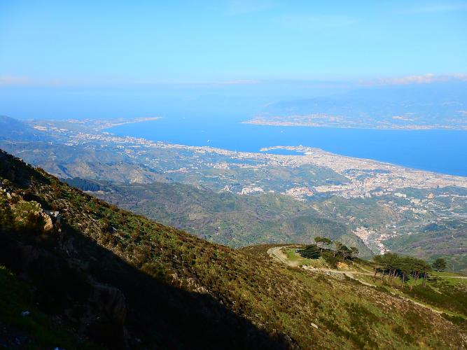
The reason to ride it is the view. The name comes from the Latin "Bimaris", for the spot where both the Ionian and Tyrrhenian seas are visible, and from the top you can see the Strait of Messina, Calabria, the Aeolian Islands and Mount Etna.
The climb is usually thought of in two halves, split at Don Minico about halfway, with the sustained hard part above it. A fort built in 1899 replaced the old Byzantine church on the summit, and the sanctuary was moved just below it.
PLAN YOUR ROUTE
 We've partnered with Sherpa-Map.com to bring you the best route planning tool. With a PRO Membership you can use this climb as a reference when creating your route.
 Dinnammare covers 18.5 km (11.5 mi) and gains 1,149 m (3,770 ft) at a 5.9% average grade, from 27 m (89 ft) to about 1,111 m (3,646 ft).
The grade is lumpy. The steepest 100 yards reach 18.1%, the steepest half mile (0.8 km) averages 11.2%, the steepest kilometer 11.7% and the steepest mile (1.6 km) 11.0%. The steepest 5 km (3.1 mi) averages 7.6%, so the average is brought down by easier sections between the hard ramps.
Roadway: The climb is on asphalt, using city streets and provincial roads that wind through wooded hillside. The first half includes stretches of old stone-block paving on the bends. The steepest 91 m (100 yd) reach 18.1%, and the steepest kilometer averages 11.7%.
Traffic: Messina city traffic at the start, then it thins out as the road climbs into the hills, with more cars on summer weekends when visitors drive up to the sanctuary. Around August 3-4 many pilgrims make the climb for the annual procession, so expect crowds.
Parking: The sanctuary is also reachable by car, so you can drive up and ride only part of the climb. Water is scarce on the mountain, and the sandwich shop at Don Minico is the reliable refreshment stop.
Bring plenty of water and food: there are very few water points above the city, and the sandwich shop at Don Minico, about halfway, is the main stop. Sicilian summers are hot and the lower half is exposed, so start early.
The top is a ridge at about 1,100 m (3,609 ft) and can be much windier and cooler than the waterfront, so pack a light layer.
Before heading out on any cycling adventure check out our Things to Bring on a Cycling Trip and use our interactive check list to ensure you don't forget anything.
The sanctuary of the Madonna di Dinnammare is the center of an annual night procession on August 3-4, when pilgrims carry the painting from the Church of Larderia up to arrive for Mass at sunrise. The summit also holds the remains of an 1899 fort, part of the Umbertine forts built to control the Strait of Messina, and the Dorsale dei Peloritani hiking route begins just below the top. The ridge is a natural place to watch the birds that cross the Strait every year.
The summit balcony is described as one of the best places on the whole Sentiero Italia to watch the sunset, so a late-afternoon ride up works well if you plan a careful descent. See our Piazza d'Armi - Don Minico and Ritiro - Don Minico climbs, which start in the same part of Messina, and use our Routes in the Area tool to see other climbs nearby.
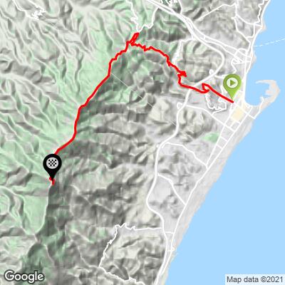
ROUTE MAP
MEMBER RATING
CURRENT WEATHER
PJAMM TRIPS ADVENTURE STARTER BUNDLES
Check out PJAMM Adventure's prepackaged (self-guided) cycling trips. They will help you plan, document and conquer your next adventure.
NEARBY CLIMBS (0) RADIAL PROXIMITY
FROM No Climbs Found
MEMBER REVIEWS & COMMENTS
Let us know what you thought of this climb. Signup for our FREE membership to write a review or post a comment.
Already have an account?
LOG IN HERE
