
17.8
PDI
10.1 mi
DISTANCE
3,242 ft
GAINED
5.7 %
AVG. GRADE
FULL CLIMB STATS
INTRO
PLAN YOUR ROUTE
 We've partnered with Sherpa-Map.com to bring you the best route planning tool. With a PRO Membership you can use this climb as a reference when creating your route.
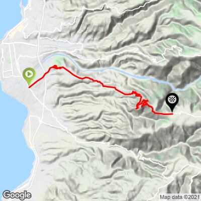
Our route covers 16.2 km (10.1 mi) from 37 m (122 ft) in Ravagnese to 960 m (3148 ft) on the road toward Santa Venere, a gain of 988 m (3242 ft) at an average of 5.7%. It includes about 66 m (216 ft) of descent along the way.
The first 4 km (2.5 mi), through Ravagnese and Gallina, average 5.2%. Between km 4 and km 7 the road rolls past Puzzi, gaining only about 65 m (213 ft), with a few short dips. From Armo, at about km 7.5, the climb begins in earnest: the last 8.7 km (5.4 mi) average 7.1%. The kilometer just above Armo is the steepest at 10.2%, followed by a long run of kilometers at 6% to 8% before the grade eases over the final kilometer.
The steepest 0.5 km (0.3 mi) averages 11.6%, the steepest 1 km (0.6 mi) 10.6%, the steepest mile (1.6 km) 9.6%, the steepest 2 km (1.2 mi) 9.5%, the steepest 5 km (3.1 mi) 8.1% and the steepest 10 km (6.2 mi) 6.6%.
Roadway: Paved throughout. The first few kilometers are ordinary suburban streets in Ravagnese and Gallina, passing the Arangea and Gallina junction of the Reggio Calabria motorway link. Above Armo the road narrows to a single-lane hill road with guardrails on the exposed bends, and the pavement is patched and broken in places, so pick your line carefully on the descent.
Traffic: Busiest at the start, where you are riding through built-up neighborhoods near the motorway junction and the airport. Traffic thins on Via Provinciale Armo, and above Armo it is light and almost entirely local.
Parking: The start is in a residential district with no dedicated lot, so use ordinary street parking in Ravagnese or Gallina and be considerate of residents. For a shorter, harder ride, start in Armo, which leaves the steep upper 8.7 km (5.4 mi) and about 615 m (2018 ft) of climbing.
Gear: The upper half averages over 7% with a kilometer above 10% and short ramps near 12%, so a compact crankset with a 30 or 32 tooth largest cog is a good choice. Wider tires help on the patched upper road.
Provisions: Fill up in Ravagnese or Gallina, which have shops and bars. Armo is a small village of about 250 people, and there is nothing reliable above it, so carry two bottles - the lower slopes face the sea and get very hot in summer, and early mornings are the best time to ride from June to September.
Before heading out on any cycling adventure check out our Things to Bring on a Cycling Trip and use our interactive check list to ensure you don't forget anything.
Take a few minutes in Armo, whose name comes from an old Calabrian word for a cliff or rocky spur. In the 10th century the monks Arsenio and Elias retreated here to pray, and their community grew into the Basilian monastery of Sant'Eustrazio, active through the years of Saracen raids. Later the monastery of Santa Maria in Trapezomata carried on the Greek monastic tradition until the 1783 earthquake left it abandoned. A Greek-rite church of Santa Maria is recorded here as early as 1310, with an icon of the Dormition honored on August 15. Armo has featured repeatedly in FAI's "I Luoghi del Cuore" campaign, and next to its cemetery a row of burial niches holds the remains of migrants lost at sea off this coast.
The start's closeness to Reggio Calabria's airport makes this an easy first ride after flying in. For the city itself and the roads to Gambarie and Montalto, see our Reggio Calabria, Galico - Gambarie and Mosorrofa pages, or see other climbs nearby, and build a custom route from here, with our Routes in the Area tool.
ROUTE MAP
MEMBER RATING
CURRENT WEATHER
PJAMM TRIPS ADVENTURE STARTER BUNDLES
Check out PJAMM Adventure's prepackaged (self-guided) cycling trips. They will help you plan, document and conquer your next adventure.
NEARBY CLIMBS (0) RADIAL PROXIMITY
FROM No Climbs Found
MEMBER REVIEWS & COMMENTS
Let us know what you thought of this climb. Signup for our FREE membership to write a review or post a comment.
Already have an account?
LOG IN HERE
