
19.3
PDI
15 mi
DISTANCE
4,096 ft
GAINED
4.3 %
AVG. GRADE
FULL CLIMB STATS
INTRO
PLAN YOUR ROUTE
 We've partnered with Sherpa-Map.com to bring you the best route planning tool. With a PRO Membership you can use this climb as a reference when creating your route.
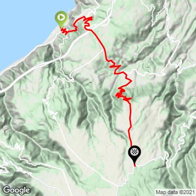
The climb averages 4.3% over 24.1 km (15.0 mi), with 1248 m (4096 ft) of climbing and about 226 m (742 ft) of descending along the way. The steepest 500 m averages 13.4%, the steepest 1 km 11.8%, the steepest 2 km 8.4%, the steepest 5 km 7.4% and the steepest 10 km 6.3%.
The first 5 km (3.1 mi) are the hardest sustained section at 7.0%. The grade then eases toward a high point of about 575 m at 9.2 km (5.7 mi), followed by a 3.9 km (2.4 mi) descent at about 2.8% to roughly 468 m. The second climb runs 11 km (6.8 mi) at 5.7%, with several kilometers between 7% and 8.6%, before the final 4.1 km (2.5 mi) ease to 3.7% on the approach to the junction.
Roadway: The route is paved throughout. It leaves Bagnara on the SS18, climbs through Ceramida and then follows the ANAS road inland toward the Aspromonte, before the final climb up to the SP3, the road linking Melito di Porto Salvo with Delianuova. Expect hairpins on the coastal hillside and a more open mountain road above the mid-climb descent.
Traffic: The first kilometers carry local traffic through Bagnara's hamlets. Higher up the road serves scattered hamlets and farms, but the SS18 and the ANAS road are through routes, so expect some cars at any time of day.
Parking: This climb shares its start with our Bagnara Calabra - Solano Superiore climb, so the same advice applies: park in Bagnara's lower town, or arrive by train at Bagnara's railway station and ride from there.
Provisions: Stock up in Bagnara before you go. Beyond Pellegrina and Ceramida the route is rural, with nothing dependable for food or water on the long second half.
Gear: With ramps above 13% early and more than 24 km (15 mi) of riding, compact gearing is the sensible choice. Remember that the mid-climb descent is followed by 11 km (6.8 mi) of real climbing - save something for it.
Weather: The finish is more than 1000 m (3300 ft) above the coast, so carry a layer for the cooler air up top and for the long descent back to the sea.
Before heading out on any cycling adventure check out our Things to Bring on a Cycling Trip and use our interactive check list to ensure you don't forget anything.
Pellegrina, a hamlet of about 1000 people at the foot of the climb, is home to two ceramics workshops whose pieces are exported around the world - worth a stop before or after the ride. The terraced vineyards of Bagnara's hillsides produce the local Zibibbo, celebrated at the Sagra dello Zibibbo, usually held in September. In August the Sagra del Pescespada is the time to see the spadare, Bagnara's swordfish boats with their tall central lookout towers. For a wide view over the Strait, head to the Torre Ruggiero at Capo Rocchi. Bagnara's old center, castle and seafront are covered on our Bagnara Calabra - Solano Superiore page.
The finish lies in the municipality of Sant'Eufemia d'Aspromonte, which is also home to the Cippo Garibaldi, the spot where the wounded Giuseppe Garibaldi was rested in August 1862, with his mausoleum beside it. Many other climbs start along this coast and in the Aspromonte - use our Routes in the Area tool to see what else is nearby.
ROUTE MAP
MEMBER RATING
CURRENT WEATHER
PJAMM TRIPS ADVENTURE STARTER BUNDLES
Check out PJAMM Adventure's prepackaged (self-guided) cycling trips. They will help you plan, document and conquer your next adventure.
NEARBY CLIMBS (0) RADIAL PROXIMITY
FROM No Climbs Found
MEMBER REVIEWS & COMMENTS
Let us know what you thought of this climb. Signup for our FREE membership to write a review or post a comment.
Already have an account?
LOG IN HERE
