
22
PDI
10.3 mi
DISTANCE
3,644 ft
GAINED
6.6 %
AVG. GRADE
FULL CLIMB STATS
INTRO
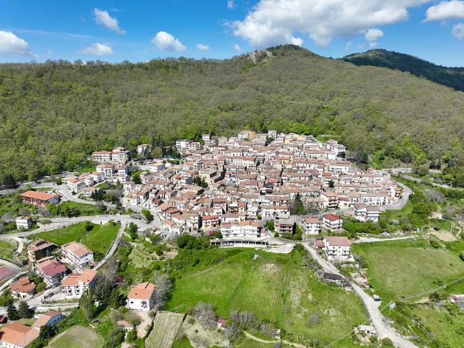
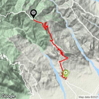
Villapiana - Plataci climbs 16.6 km (10.3 mi) from the edge of Villapiana's old town, a short ride inland from Calabria's Ionian coast, into the eastern flank of the Pollino massif. It gains 1,111 m (3,644 ft) at a 6.6% average, rising from about 150 m (490 ft) at the start to the wooded slopes above Plataci at about 1,250 m (4,100 ft). The village itself sits at about 930 m (3,050 ft), looking back over the Sibari plain and the Ionian Sea.
This is a climb that never lets up and never wrecks you. The hardest 10 km (6.2 mi) averages 6.7% against 6.6% for the whole route, so the effort is even from bottom to top, with the steepest kilometer at 10.6%. The road, the provincial SP 159, is the only route to Plataci, which gives it a quiet, local character, and the final kilometers run narrow and unmarked through woodland.
Plataci is worth the effort on its own. It is an Arbëreshë village - an Albanian-speaking community founded by exiles who settled here around 1476 - and its old streets are decorated with murals of its history and traditions. To see the other Ionian-side climbs in this corner of Calabria, try our Routes in the Area tool.
PLAN YOUR ROUTE
 We've partnered with Sherpa-Map.com to bring you the best route planning tool. With a PRO Membership you can use this climb as a reference when creating your route.
 The average grade is 6.6% over 16.6 km (10.3 mi), climbing about 1,100 m (3,600 ft) from Villapiana to the woods above Plataci.
The steepest 90 m (100 yards) reaches 15.3%, the steepest 0.4 km (0.25 mi) 12.9% and the steepest 0.5 km (0.3 mi) 12.0%. The steepest kilometer (0.6 mi) averages 10.6%, the steepest 2 km (1.2 mi) 9.4%, the steepest 5 km (3.1 mi) 7.5% and the steepest 10 km (6.2 mi) 6.7%.
What stands out is how little the numbers spread out: the hardest 10 km averages just 0.1 percentage points more than the whole climb. There is no long flat to recover on and no single wall, so pick a gear you can hold from the first ramp above Villapiana and ride the whole thing at one steady effort.
Roadway: The climb follows the provincial road SP 159, which is paved from Villapiana to the top of the route. The upper kilometers narrow to a single lane wide with no center line as the road runs through woodland, so be ready to slow for oncoming vehicles on the bends. Because SP 159 is the only route up to Plataci, any closure cuts the village off - it was closed at Villapiana in mid-August 2024 for the town's patron festival, so check ahead if you plan to ride around then.
Traffic: This is a local road serving Plataci, so the vehicles you meet are mostly residents and visitors heading to the village.
Parking: The climb starts at the entrance to Villapiana's old town, beside the town sign on the road up from the coast. The coastal parts of the municipality, Villapiana Lido and Villapiana Scalo, are on the SS106 Jonica and each has a station on the Jonica railway (Villapiana Lido, and Villapiana-Torre Cerchiara at Scalo), which makes them practical places to arrive without a car and ride up.
You start near sea level and finish more than 1,000 m (3,300 ft) higher, so the temperature at the top can be several degrees cooler than on the coast, and the woodland near the finish is shadier than the open lower slopes. Bring a light windproof layer for the descent, and sun protection for the open sections near Villapiana.
Fill your bottles in Villapiana before you start and carry food, with Plataci as the natural place to stop and top up. Compact gearing with a wide cassette makes the 10% ramps far more comfortable.
Before heading out on any cycling adventure check out our Things to Bring on a Cycling Trip and use our interactive check list to ensure you don't forget anything.
Plataci (Pllatëni in Albanian) is one of the Arbëreshë villages of the Pollino, founded in the 15th century by Albanian exiles after the death of their hero Skanderbeg. Its old center keeps the Church of San Giovanni Battista, whose interior serves the Byzantine-Greek rite, and the Church of Madonna di Costantinopoli, and the walls are painted with murals of village life. Local specialties are stridhlë - homemade pasta with a kid or chicken ragù - and dried figs stuffed with nuts, and the area's olive oil carries the Bruzio DOP Sibaritide designation.
Down at the coast, Villapiana's old town stands at about 206 m (676 ft), and the Lido and Scalo below it hold the beaches and the Jonica railway stations. If you want more climbing from the same base, the Santuario Madonna delle Armi above Cerchiara di Calabria is another Ionian-side climb in our database, and it can be linked with Plataci into a loop from Villapiana Lido.
ROUTE MAP
MEMBER RATING
CURRENT WEATHER
PJAMM TRIPS ADVENTURE STARTER BUNDLES
Check out PJAMM Adventure's prepackaged (self-guided) cycling trips. They will help you plan, document and conquer your next adventure.
NEARBY CLIMBS (0) RADIAL PROXIMITY
FROM No Climbs Found
MEMBER REVIEWS & COMMENTS
Let us know what you thought of this climb. Signup for our FREE membership to write a review or post a comment.
Already have an account?
LOG IN HERE
