Climb Summary
![IMG_5107.JPG]()
The Piemonte Region (northwestern Italy, along the southeastern French border) while not altogether “forgotten” does not have the extraordinary popularity of the Trentino-Alto Adige Region (Stelvio/Gavia/Mortirolo) or the Dolomites. Regardless of its relative obscurity and minimal Giro appearances, the 3 routes to the Passo della Fauniera are exceptional and highly recommended climbs - you will not regret traveling a few hours to tackle one or more of the Faunieras.
![IMG_5104.JPG]()
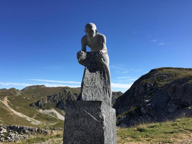
Another Marco Pantani Monument - dedicating his epic climb in the 1999 Giro
(see also Mortirolo and Finestre for other Pantani memorials)
![IMG_4242.JPG]()
Beginning of climb - Fauniera (dei Morti) - and “climb of Fausto Coppi”
Colle della Fauniera is the 7th highest paved pass in Italy at 2,478m/8,131’ in the Cottian Alps in the Piemonte Region of Italy. The colle is also known as Colle dei Morti (“Hill of the Dead”), deriving from fierce fighting and many deaths resulting from battle between Franco-Spanish and Piedmontese troops during a battle in 1744. “The pass of the Dead - in memory of the French and Spanish soldiers ambushed and stoned to death here by their Savoyard enemies in 1744. That was a wretched story , all the more so because peace between the warring factions had just broken out in the valleys, but too late to get news to the men on the mountain.” Daniel Friebe, Mountain Higher Quercus Press.
GIRO HISTORY
Note 1: The 2003 Giro went only to Colle Esischie which is just .9 miles/1.2km short of Faunieria summit.
Note 2: The Fauniera stage from Pradleves was cancelled in 2001 due to the “San Remo Blitz”[1]
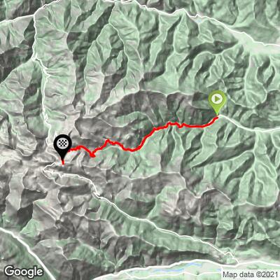
There are 3 routes to the summit of Fauniera, all along narrow, steep, unique and wonderful roads.
From Pradleves
This appears to be the more popular route, by a factor of at plus 3 - as of October 13, 2016, Strava shows:
- 1,696 attempts for Pradleves,
- 505 for Demonte, and
- 384 for Marmora..
This is also ranked more difficult than the other 2 routes by a slight margin with a tough 8.4% overall average grade followed by Demonte at 7.8% and Marmora bringing up the rear with a mere 7%!
There are 4 avalanche tunnels for about a mile (1.6 km) starting at mile 4.5 (7.2 km), an obvious testament to the extreme steepness of the mountainsides in the area. There is a very quaint village at the 7 mile / 11 km point (Chiappe) and the grade for the .8 mile / 1.1 km through this area is a stout 10.1%. In addition to the incredible grade, we have exceptional views of the flowering meadows and steep mountain walls bordering the village as we pass through it (rarely do we ride through a village road of this distance with such a severe grade to it).
![Grades.JPG]()
![IMG_4319.JPG]()
From the village, the road, which was none too wide to that point, narrows to a true one-laner for the remainder of the climb. Until 1983 this was an old military roadway in disrepair. However, in anticipation of the opportunity to be included for the first time in the Giro d’Italia, work began to improve (apparently not “widen”) the road; see, Daniel Friebe, Mountain Higher Quercus Press. On the weekend day in late August, 2016 that we climbed Fauniera, there were many couples and families enjoying an afternoon meal picnic-style along the side of the road overlooking miles and miles of spectacular scenery along the route between Chiappi and the colle.
![IMG_4362.JPG]()
Hey, when we say narrow, we mean it!
At mile 12.1 (km 19.5) we pass Colle Esischie (also known as Colle della Fauniera from Marmora) and it is just another .9 miles (1.4 km) to the top summit.
![IMG_4397.JPG]()
View from the intersection of Colle Esischie (Fauniera from Marmora) and Fauniera from Pradleves
From Marmora
This is the “least popular” of the 3 routes up Fauniera, but perhaps the most unique. And, while there are 5 times more “attempts” on Strava for Pradleves than for Marmora, we did encounter several cyclists during our time on this side of the mountain. Fauniera from Marmora is really Colle Esischie + .9 miles (1.4 km).
![IMG_4555.JPG]()
As with the Pradleves, there are KM markers along this route
The roadway is very rough and rugged from mile 2 (km 3.5) for the remainder of its length and the descent is particularly painful on the hands, so well cushioned gloves are advisable. We ride along a creek and through a short tunnel at the beginning of the climb, then through and above a narrow canyon as we ascend this very steep road towards Colle Esischie and Fauniera. There is a nice set of 10 switchbacks from mile 7 to 8.5 (km 11.2 to 13.7) and several very old structures (many in disrepair) along the middle and upper portions of the ascent.
![File:Achtung.svg]() Tunnel - Bring flashing tail lights and a high lumen headlight
Tunnel - Bring flashing tail lights and a high lumen headlight
![IMG_4426.JPG]()
There are a couple of short tunnels a couple miles up the road
![Grades.JPG]()
From Demonte
We were extremely disappointed to run out of time and thus be turned back just a few miles into our trip up Fauniera from Demonte. Our research shows us that this route is quite challenging and involves very similar narrow roads with exceptional beauty as its Pradleves and Marmora counterparts. Fortunately, The Bike Rebel has an excellent summary of this ascent of Fauniera:
“Wednesday – Colle Fauniera
More aptly referred to as “Colle dei Morti” as I found out very quickly. The start is irregular, with frequent ups and downs, where the “ups” are basically close to and over 10% – there is no easing into this one…
The views, however, get more spectacular by the kilometer. There’s little traffic, which also may have to do with the pass being (sorta) closed at the top, on account of a massive patch of snow – we didn’t know that when we started, although I did see an announcement (in Italian, probably saying something about it) patched to a sided fence when we returned later on.
That fence was probably tossed aside to enable big trucks to pass. Despite the road being closed to mini vans, campers and caravans, the Italians do not mind hauling their 30 ton trucks up the mountain to unload cattle. Eventually, these trucks will have to turn and get down the mountain again and we got stuck in a traffic jam when the road got completely blocked because of this…
After that, we had the road to ourselves, besides meeting the occasional Alpine Marmot. It got chillier and chillier the more I advanced towards the summit and the sometimes strong gusts of winds made the real feel of the second half rather arctic.
Close to the summit, I had to plow through the snow to be able to continue the last 400 meters or so, but I really wanted to reach the Pantani monument there. Paula was lucky to be able to turn the car on a small plateau – going down backwards would have been impossible…
All in all, this has probably been the most beautiful pass I’ve climbed thus far. And I rate it higher – in difficulty – than the Stelvio, despite the ClimbByBike rating(s). More general info on it here.
Trip: 25.2 kilometers / 1,928 meters elevation – Strava” The Bike Rebel
![IMG_4710.JPG]()
About one mile (1.6 km) up the climb from Demonte
This southern route to Colle Fauniera is only 7 miles (11.2 km) from the start of Colle de la Lombarde, a hefty 13 miles / 21 km climb south to the French border. See map of Area Top Climbs, below on this PJAMM Climb Page).
![]()
Wayside shrine at above the colle
![Grades.JPG]()
Steepest kilometer starts at km 12.9 (10.7%)
[1] The 2001 "San Remo blitz" is the term assigned to the day when two police forces raided the Giro in search of drugs which sadly destroyed what remained of Marco Pantani's credibility (The Guardian Article)