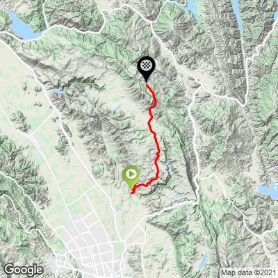
9.9
PDI
8.3 mi
DISTANCE
2,118 ft
GAINED
4.5 %
AVG. GRADE
FULL CLIMB STATS
INTRO
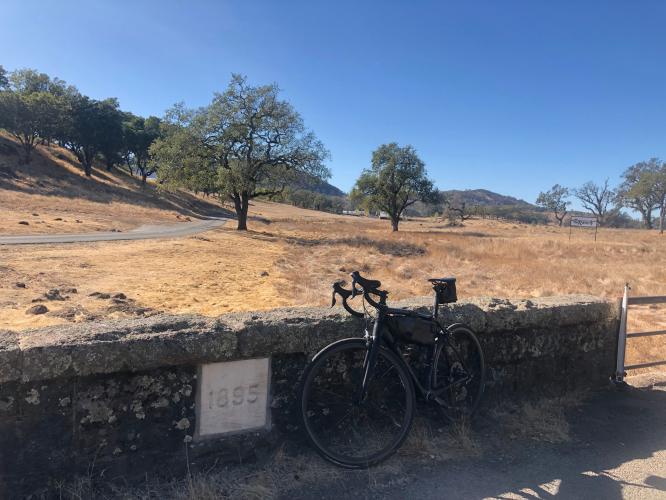
This is a rural and generally private climb through the southeastern section of Napa County into the Vaca Mountain Range which is home to Atlas Peak Appellation. This climb starts just past the golf course and quickly the grade increases as you ride through a residential area. Once you pass this the pavement becomes a little more bumpy and the climbs takes deep into the heart of Napa. This dead ends at a vineyard with a nice spot to stop and eat. The way down is fast and fun.
PLAN YOUR ROUTE
Average grade is 4.5% (5.4% with descent eliminated). 44% of the climb is at grade 0-5%, 43% is at 5-10%, and 3.3% is at 10-15%. The steepest quarter-mile is 10.3% and steepest mile 8%.
See more details and tools regarding this climb's grade via the “Profile Tool” button.
Roadway: Two lane roadway with a center stripe that becomes a narrow two lane road without a center stripe at mile 5.7 at a bridge near the entrance to a ranch on the left - Map; Street View. The pavement is in good condition for the first two-thirds of the climb and fair condition for the remainder.
Traffic: Minimal.
Parking: On the side of the road just before the start of the climb - Map; Street View.
Provisions: None on the ride, but try the Silverado Bakery a mile from the start of the climb - in the country club parking lot - Map.
Before heading out on any cycling adventure check out our Things to Bring on a Cycling Trip and use our interactive check list to ensure you don't forget anything.
Use the “Routes in Area” button on the menu bar to see other bike climbs in this area.
If you have travelled to Napa County to cycle, you are welcome to contact me at john@pjammcycling.com if you have any questions about the area - I grew up and live in neighboring Sonoma County, but do have a good working knowledge of Napa.
ROUTE MAP
MEMBER RATING
CURRENT WEATHER
PJAMM TRIPS ADVENTURE STARTER BUNDLES
Check out PJAMM Adventure's prepackaged (self-guided) cycling trips. They will help you plan, document and conquer your next adventure.
NEARBY CLIMBS (0) RADIAL PROXIMITY
FROM No Climbs Found
MEMBER REVIEWS & COMMENTS
Let us know what you thought of this climb. Signup for our FREE membership to write a review or post a comment.
Already have an account?
LOG IN HERE
lirizar1
Nice peaceful climb out of Napa with minimal cars and lots of nice views. The beginning starts out steeper than expected but quickly levels off in the middle to almost flat and almost a mile of downhill 3/4 of the way up. Almost at the end there is a short segment of 10%+. Excellent road surface for the first 4 miles or so (4/5) then it becomes average before turning to 1/2. Manageable to go up the poor road conditions but the first 2-3 miles descending are pretty brutal. Also the last 3+ miles the road narrows significantly so be careful for a car speeding around a turn. Cars were few and very respectful (stopping to let you pass where it was narrow) but be careful!