Lambs Knoll Bike Climb - PJAMM Cycling

6.9
PDI
2.5 mi
DISTANCE
1,037 ft
GAINED
7.7 %
AVG. GRADE

FULL CLIMB STATS

Page Contributor(s): Nigel Brockton, Fairfax, VA, USA; Dan Razum, Campbell, CA

INTRO

This 2.5 mile bike climb is located in MD, USA. The average gradient is 7.7% and there is a total elevation gain of 1,037 ft, finishing at 1,751 ft.

Use the profile tool, route map, and weather forecast to conquer this cycling climb.

See more details and tools regarding this climb's grade via our interactive Profile Tool.
Information Not Available

If you have any information regarding this climb, we'd like to hear from you. Click the CONTRIBUTE button to share your thoughts with us.

Information Not Available

If you have any information regarding this climb, we'd like to hear from you. Click the CONTRIBUTE button to share your thoughts with us.

Before heading out on any cycling adventure check out our Things to Bring on a Cycling Trip and use our interactive check list to ensure you don't forget anything.
Information Not Available

If you have any information regarding this climb, we'd like to hear from you. Click the CONTRIBUTE button to share your thoughts with us.

ROUTE MAP

MEMBER RATING

Difficulty: Moderate
5
Road
5
Traffic
3
Scenery

CURRENT WEATHER

PJAMM TRIPS ADVENTURE STARTER BUNDLES

Check out PJAMM Adventure's prepackaged (self-guided) cycling trips. They will help you plan, document and conquer your next adventure.
ALL TRIPS
Browse all of our prepackaged trips and find your next adventure!
The Blue Ridge Parkway (North)
United States (NC,TN,VA)
38 ROUTES
70 POIs
ROUTE STATS (TOTAL)
716.5
mi
DISTANCE
75,697
ft
ELEV. GAIN
The Blue Ridge Parkway (South)
United States (NC,TN,VA)
30 ROUTES
63 POIs
ROUTE STATS (TOTAL)
690.7
mi
DISTANCE
74,180
ft
ELEV. GAIN

NEARBY CLIMBS (0) RADIAL PROXIMITY

FROM
No Climbs Found

MEMBER REVIEWS & COMMENTS

Let us know what you thought of this climb. Signup for our FREE membership to write a review or post a comment.
Already have an account?

May 30, 2021
difficulty: Moderate
scenery: 3
traffic: 5
road: 5
May 30, 2021
scenery: 3
traffic: 5
road: 5
I climbed this on my unicycle and was surprised to find an unmarked secure government facility at the top where the road ends. Turns out to be a decommissioned cold war era Presidential Emergency Facility code named "Corkscrew". It houses a fortified microwave communication silo and underground bunkers. Pretty neat find.
ROUTE MAP
PROFILE TOOL
Route Data
S.G. (%)
hide
Segment Data
hide
CLIMB SUMMARY

Cycling Lambs Knoll

Ride 2.5 miles gaining 1,040’ at 7.7% average grade.

Climb summary by PJAMM ambassador Dan Razum, Campbell, CA.

We start the climb on Reno Monument Road, about a half mile before Lambs Knoll Rd.  The climbing is steep from the start but we can warm up a little by starting further down Reno Monument Road, before the climb proper.  

Reno Monument is a narrow 2 lane road, with some traffic but not too bad.  The pavement is in good condition but there is no shoulder. After a stout climb on Reno Monument we turn right onto Lambs Knoll Rd.  There are some interesting  historical markers at the junction.

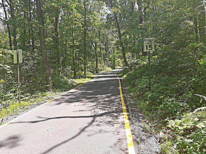
Lambs Knoll Rd is a narrow single lane road leading to a government facility and a large antenna. There is very little traffic on this road and there are pullouts every so often to allow vehicles to pass each other.  It is a true single lane road and if two vehicles going in opposite directions meet, one of them would have to back up to a pullout in order to pass by.  The pavement is quite  smooth, the road is well maintained.

Lambs Knoll is gentle for the first half mile, a nice breather after Reno Monument.  But then it

starts to climb, hitting double digits in several places.  We pass through heavy woods so there

is ample shade. There aren't any views along this climb, due to the thick vegetation.  Even at the

top we don't get any view of the surrounding countryside.

Near the top, there is a junction, if you go to the right you will arrive at the gate, a couple hundred yards from the junction.  If you go to the left, you will arrive at the antenna, maybe 500 yards from the junction.  The antenna is a little higher than the gate, and the road ends there, so you can't go any further unless you want to hike through thick forest.  So the antenna is the logical top of the climb.

Go left at the junction at mile 2.4

Climb finishes at the antenna.

Overall, this is a nice climb through a peaceful forest and the climb felt safe, despite the narrow road.