
15.7
PDI
8.8 mi
DISTANCE
2,708 ft
GAINED
5.8 %
AVG. GRADE
FULL CLIMB STATS
INTRO
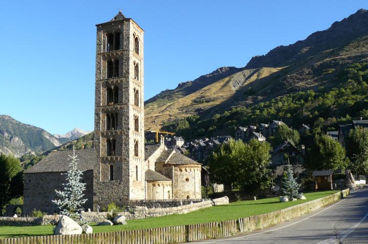
Sant Climent de Taüll stands right beside the road about 4 km into this climb, and it's hard not to slow down for it: a slim six-storey stone bell tower and a church consecrated in 1123, with a copy of its famous Pantocrator painted back into the apse (the original hangs in Barcelona's MNAC). It's one of the Romanesque churches that put the Vall de Boí on UNESCO's World Heritage list in 2000, and two more of them sit just off the route - Sant Joan in Boí and Santa Maria in the middle of Taüll.
Above the village it becomes a proper mountain road. From the L-500 it's 14.1 km (8.8 mi) to the base of the Boí Taüll ski resort, with 825 m (2708 ft) of climbing at 5.8%, and the hard part comes first: out of Boí the road goes up at 7.5 to 8.6% for four straight kilometers to Taüll and just beyond. Then it eases to around 4.5% across the hillside, goes almost flat for a kilometer at about km 9, and the last 5 km wind up through the hairpins at 6 to 7%, out of the pines and onto open grass under the ski lifts.
At the top there's a big car park and the resort building at 2039 m (6689 ft), with the high Pyrenees all around. In winter it's a ski station; from late June to the end of August the resort runs a summer season with the Vaques chairlift, zip lines from the base terrace and marked hiking and e-bike routes. Outside those months it's a quiet dead end, and the descent back to Boí is the reason to come up - long open bends at the top, then tighter and steeper coming down into Taüll.
PLAN YOUR ROUTE
 We've partnered with Sherpa-Map.com to bring you the best route planning tool. With a PRO Membership you can use this climb as a reference when creating your route.
Overall: 14.1 km (8.8 mi) with 825 m (2708 ft) of climbing at a 5.8% average, from 1228 m (4030 ft) on the L-500 to 2039 m (6689 ft) at the ski-resort car park.
Km 0-1: 3.5% - up the valley road and into Boí.
Km 1-5: 8.6%, 7.9%, 7.5% and 7.6% - the hardest stretch, from Boí across to Taüll and on past Sant Climent.
Km 5-8: 4.3 to 4.6% above Taüll.
Km 8-9: 1.2% - the one real breather.
Km 9-14.1: 4.2%, then 6.5%, 6.8%, 6.1% and 7% through the hairpins to the resort.
Steepest sections: 100 m at 10.1%, 500 m at 8.7%, 1 km at 8.6%, 2 km at 8.3%, 5 km at 7.5%.
Roadway: Tarmac from bottom to top. Between Boí and Taüll it's older, narrower tarmac with cracks, patches and a wooden guardrail in places; above Taüll the resort road is wider, with crash barriers and a better surface, and riders describe the upper 7 km as well paved. This is a road between 1200 and 2000 m, so expect snow and ice outside the summer months - even on a sunny winter day the shaded corners can stay icy.
Traffic: Light most of the year. The resort brings cars and coaches up from Taüll in the ski season and on summer days when the lifts are running, and that traffic is all on the road you're climbing. Early mornings and the weeks between seasons are the quietest.
Parking: Boí has a daytime car park on the Carretera de Taüll at the edge of the village, with drinking-water taps, and the 4x4 taxis into the Aigüestortes national park leave from right beside it. It's a few hundred meters above our start, so either roll down to the L-500 junction or simply start from the car park. There's also a large car park at the top, at the resort building.
Gear: The opening kilometers at close to 8% set the gearing - a compact with a 30 or 32 at the back keeps it comfortable, and everything after Taüll is steadier. You finish above 2000 m on an open slope, so carry a jacket for the way down; the weather at the car park often has little to do with what you saw in Boí, and our Weather tool gives you the forecast for the top.
Provisions: Boí and Taüll both have bars and restaurants, and the Boí car park has water. Fill your bottles before you leave Taüll - above the village there's nothing on the road, and outside the ski and summer seasons nothing open at the top either.
Before heading out on any cycling adventure check out our Things to Bring on a Cycling Trip and use our interactive check list to ensure you don't forget anything.
Boí, Taüll and Barruera are the places to stay in the valley, from hotels to rural houses, and Taüll has the most restaurants. The Romanesque churches are the obvious rest-day plan: nine of them within a few kilometers, from Sant Climent and Santa Maria in Taüll to Sant Joan in Boí and Santa Eulàlia in Erill la Vall, where the Centre del Romànic de la Vall de Boí is the place to start.
The other rest day is the Aigüestortes i Estany de Sant Maurici national park, whose Sant Nicolau valley entrance is just up the L-500 from Boí. Private cars stop at the Palanca de la Molina car park; the 4x4 taxis from Boí run on up to Aigüestortes itself.
For more riding, our Durro page is a short climb from Barruera just down the valley, and the steep road to the Llauset tunnels (our Cruce Carretera - Tunel Llauset page) is over the hill near Vilaller. The Val d'Aran and the Port de la Bonaigua look close on the map, but they're on the far side of the mountains - about an hour by car through the Vielha tunnel.
ROUTE MAP

MEMBER RATING
CURRENT WEATHER
PJAMM TRIPS ADVENTURE STARTER BUNDLES
Check out PJAMM Adventure's prepackaged (self-guided) cycling trips. They will help you plan, document and conquer your next adventure.
NEARBY CLIMBS (0) RADIAL PROXIMITY
FROM No Climbs Found
MEMBER REVIEWS & COMMENTS
Let us know what you thought of this climb. Signup for our FREE membership to write a review or post a comment.
Already have an account?
LOG IN HERE
