
19.8
PDI
6.9 mi
DISTANCE
2,796 ft
GAINED
7.6 %
AVG. GRADE
FULL CLIMB STATS
INTRO
This climb follows the road that serves the village of Aneto and the Llauset reservoir, in the Pyrenees of the Alta Ribagorza. It covers 11.2 km (6.9 mi) and gains 852.2 m (2,796 ft), from 1,285.0 m (4,216 ft) to 2,131.8 m (6,994 ft), at a 7.6% average, and ranks #1,019 on our list of the world's hardest climbs.
The average understates it. The steepest 0.5 km (0.3 mi) averages 20.4%, the steepest kilometer 13.9% and the steepest 5 km (3.1 mi) 9.0%, so this is a climb with real walls in it. The road is narrow, quiet and not always well surfaced, and it feels more like a hydroelectric access track than a conventional col. Views open out over the Barrabés valley as you climb, and the road eventually reaches a series of old concrete tunnels built for the Llauset reservoir.
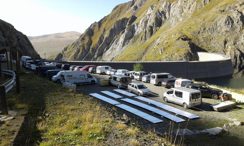
The climb ends at the tunnel junction. Beyond it the road continues through the tunnels to the Llauset dam and the parking area at roughly 2,200 m (7,218 ft), a trailhead for the high lakes of the Posets-Maladeta area. The road is a summer proposition: with snow, the tunnels are closed to vehicles.
PLAN YOUR ROUTE
 We've partnered with Sherpa-Map.com to bring you the best route planning tool. With a PRO Membership you can use this climb as a reference when creating your route.
The climb averages 7.6% over 11.2 km (6.9 mi), gaining 852.2 m (2,796 ft) from 1,285.0 m (4,216 ft) to 2,131.8 m (6,994 ft).
The profile is anything but even. The steepest quarter mile (0.4 km) averages 25.6%, the steepest 0.5 km (0.3 mi) 20.4%, the steepest kilometer 13.9% and the steepest 2 km (1.2 mi) 12.3%. Over longer distances it settles to 9.0% for the steepest 5 km (3.1 mi) and 7.9% for the steepest 10 km (6.2 mi). Bring gearing you can turn over at a crawl, and pace the opening kilometers.
Roadway: The road is narrow and its surface varies: it is paved but patchy in places and described as not well paved, and riders report that it can be ridden on a road bike. Higher up it passes old concrete tunnels dating from the 1950s and 1960s, and the last, long tunnel to the reservoir is unpaved with ruts and doors. The tunnel is closed to vehicles in snow season, and in snow the road is not an option.
Traffic: Light. The road mainly serves hikers and day visitors heading for the Llauset reservoir and the high lakes, and many campervans stop at the reservoir parking.
Parking: There is no formal parking at the start junction near Aneto, so park considerately and do not block farm access. At the Llauset reservoir there is a parking area at roughly 2,200 m (7,218 ft) beyond the tunnels, which is the start point for the area's hiking routes.
Provisions: There are no services on the climb, so carry the food and water you need from Vilaller. The Refugio Cap de Llauset, a guarded hut on the GR11 about an hour and a half's walk above the dam, is the nearest staffed refuge.
Gear: Because the surface is patchy and the pitches are steep, wider tires and a very low gear are a good idea. You end above 2,100 m (6,890 ft), so bring a jacket for the descent.
Before heading out on any cycling adventure check out our Things to Bring on a Cycling Trip and use our interactive check list to ensure you don't forget anything.
The road leaves the N-230 (Lleida-Vielha) at Senet de Barrabés and climbs toward the small village of Aneto, at about 1,380 m (4,528 ft), whose parish church has a 12th-century Romanesque bell tower. The nearest larger base is Vilaller, in Catalonia at 981 m (3,219 ft), with an 18th-century Baroque church dedicated to San Clemente, a Gothic bridge over the Noguera Ribagorzana, and a Romanesque church in Senet. Vilaller is also home to the Fallas del Pirineu, the torch descent on the eve of San Juan that is recognized as UNESCO intangible cultural heritage.
Above the climb, the Llauset reservoir is the gateway to the Posets-Maladeta Natural Park, and the Refugio Cap de Llauset on the GR11 is guarded all year with 30 places. The road is a summer-only proposition and in snow the tunnel is closed to vehicles. Check conditions at altitude before you go with our Weather tool.
ROUTE MAP

MEMBER RATING
CURRENT WEATHER
PJAMM TRIPS ADVENTURE STARTER BUNDLES
Check out PJAMM Adventure's prepackaged (self-guided) cycling trips. They will help you plan, document and conquer your next adventure.
NEARBY CLIMBS (0) RADIAL PROXIMITY
FROM No Climbs Found
MEMBER REVIEWS & COMMENTS
Let us know what you thought of this climb. Signup for our FREE membership to write a review or post a comment.
Already have an account?
LOG IN HERE
