
21.5
PDI
12.3 mi
DISTANCE
3,740 ft
GAINED
5.8 %
AVG. GRADE
FULL CLIMB STATS
INTRO
PLAN YOUR ROUTE
 We've partnered with Sherpa-Map.com to bring you the best route planning tool. With a PRO Membership you can use this climb as a reference when creating your route.
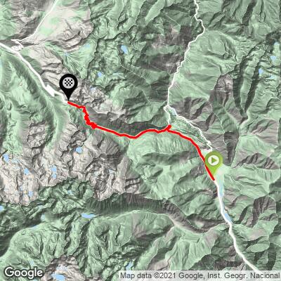
 The climb averages 5.8% over 19.7 km (12.3 mi). The opening 2 km (1.2 mi) are easy at about 3%, which makes for a smooth start. The hardest stretch then arrives quickly, at roughly 2-4 km (1.2-2.5 mi), where the road runs 8-9%: our data has the steepest half kilometer (0.3 mi) at 9.7%, the steepest kilometer (0.6 mi) at 9.3% and the steepest 2 km (1.2 mi) at 8.5%.
Above that the grade moves between 4% and 7% for the rest of the climb, with the steepest 5 km (3.1 mi) averaging 7.0% and the steepest 10 km (6.2 mi) averaging 6.3%. The middle of the mountain, from about 10 to 14 km (6.2-8.7 mi), holds 6-7%, and the last few kilometers ease to 4-5% after a 6.7% pitch near 17 km (10.6 mi). Our route climbs from 944 m (3,098 ft) to 2,078 m (6,818 ft).
Roadway: The road is paved throughout, with long straights on the lower and middle slopes and a twisty upper section of hairpins near the top. On the Val d'Aran side the road is wide with a generous shoulder. Cracking and ground movement near the pass have left the C-28 patched in places, and the stabilization work there reduces it to alternating single-lane traffic controlled by lights, so allow time for waits. Snow closes the pass at times through the cold months, so check Servei Català de Trànsit before riding outside summer.
Traffic: Hundreds of people commute across the pass every day between the Pallars and the Val d'Aran, so the C-28 carries steady local traffic, heaviest on weekday mornings and evenings. Out-of-town traffic is lighter on the Esterri side than the Aran side, and the roadworks add short queues at the signals.
Parking: The start sits on the valley road south of Esterri d'Àneu, so the simplest plan is to park in the village and ride the 2.5 km (1.6 mi) out to the start. If you would rather skip the approach, our Port de la Bonaigua, Esterri D'Àneu page starts in the center of the village.
Provisions: There is nothing on the climb itself, so stock up in Esterri d'Àneu before you go and carry enough water for the whole 19.7 km (12.3 mi). Vielha, on the Aran side of the pass, is the nearest town with a full range of services.
Gear: A compact crankset with a 30 to 32 tooth cog covers the 8-9% pitch early on and the steady 6-7% above it. Bring a windproof layer for the summit and the long descent toward Vielha, which is cooler and more exposed than the climb suggests.
Before heading out on any cycling adventure check out our Things to Bring on a Cycling Trip and use our interactive check list to ensure you don't forget anything.
The top of Bonaigua marks the boundary between two very different valleys. On the Aran side, signs use Aranese, the Occitan spoken in the Val d'Aran, in which the pass is Pòrt dera Bonaigua. Vielha, the valley's main town, has the area's hospital and most of its services, and the Baqueira-Beret ski area and the high plateau of Pla de Beret are close to the pass on that side.
To ride the pass from the Aran side, see our Port de la Bonaigua, Arties page, and for a short climb from Baqueira itself, see our Baqueira-Beret page. Esterri d'Àneu and its old quarter, market and museum are covered on our Port de la Bonaigua, Esterri D'Àneu page.
To see other climbs in the Pyrenees nearby, or build a custom route from here, try our Routes in the Area tool.
ROUTE MAP
MEMBER RATING
CURRENT WEATHER
PJAMM TRIPS ADVENTURE STARTER BUNDLES
Check out PJAMM Adventure's prepackaged (self-guided) cycling trips. They will help you plan, document and conquer your next adventure.
NEARBY CLIMBS (0) RADIAL PROXIMITY
FROM No Climbs Found
MEMBER REVIEWS & COMMENTS
Let us know what you thought of this climb. Signup for our FREE membership to write a review or post a comment.
Already have an account?
LOG IN HERE
