
21.9
PDI
6.3 mi
DISTANCE
2,906 ft
GAINED
8.8 %
AVG. GRADE
FULL CLIMB STATS
INTRO
PLAN YOUR ROUTE
 We've partnered with Sherpa-Map.com to bring you the best route planning tool. With a PRO Membership you can use this climb as a reference when creating your route.
 Montauban-de-Luchon averages 8.8% over 10.1 km (6.3 mi), and there is little in the way of a warm-up. The steepest half kilometer (0.3 mi) averages 13.2%, the steepest full kilometer (0.6 mi) 12.8%, and the steepest 2 km (1.2 mi) 11.7%; the steepest 100 yards (91 m) reaches 14.1%. Even zoomed out, the steepest 5 km (3.1 mi) average 10.3%, so the effort is steady rather than spiky.
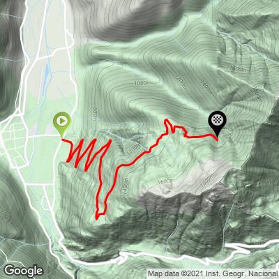
Once the road leaves the village it settles into a run of switchbacks at close to 10%, with the gradient easing only slightly toward the pasture at Herran before the final gravel stretch to the top. Pace the first kilometers conservatively and keep a low gear in reserve for the gravel.
Roadway: The climb follows the Route Forestière de Herran, a narrow forest road that leaves Montauban on the D27 and Cours de la Castagnère. It is asphalt for roughly the first 8.5 km (5.3 mi) up to the high pasture at Herran (about 1,408 m / 4,619 ft); beyond that the surface turns to compacted gravel for the final 1.5 km (0.9 mi) to 1,517 m (4,977 ft). Riders report that the paved section is largely intact but lightly maintained, and the descent needs care, so a road bike with wider tires or a gravel bike is the sensible choice. As a communal forest road it can be closed to all users for maintenance - it was shut to everyone, cyclists included, from 23 to 26 February 2026 for tree pruning - so check the Montauban-de-Luchon town hall's notices before you go.
Traffic: Essentially none. The road is closed to general motor traffic, so you will mostly share it with walkers and other riders.
Parking: Montauban-de-Luchon is a village of about 500 people just east of Bagnères-de-Luchon and has no dedicated cycling car park, so park considerately on the village streets near the start on the D27. You can also ride out from Luchon itself, which has a railway station where TER Occitanie service from Montréjeau resumed in June 2025, with a daily connection from Toulouse.
Carry everything you need before you leave Montauban or Luchon, since the forest road passes no shops. Bring two full bottles for the 10.1 km (6.3 mi) climb and some food. The surface calls for the widest tires your frame allows, or a gravel bike, and a compact crankset with a low gear will help on the sustained 10% switchbacks. The top sits at 1,517 m (4,977 ft), so pack a light layer for the descent, and take it slowly on the aging pavement.
Before heading out on any cycling adventure check out our Things to Bring on a Cycling Trip and use our interactive check list to ensure you don't forget anything.
Bagnères-de-Luchon, just down the valley, is one of the Pyrenees' classic spa towns, with 48 thermal springs between 17 and 65°C, a casino built in 1878, and a Tour de France stage-town history stretching back to 1910. The Superbagnères ski resort above it is reached by a gondola that has run since 1993, and it is the mountain you will be looking at from the pasture at Herran. Back in Montauban, the village church has a tympanum carved around 1840 by Eugène de Malbos. Luchon is packed with climbs - the Col du Portillon starts barely a kilometer from this one, and Superbagnères, Peyresourde and Port de Balès are all close - so see other climbs nearby, or map out a custom route from here, with our Routes in the Area tool.
For those looking to stay in the area we would recommend the Pyrenees Cycling Lodge. Located in the beautiful medieval village of Saint Savin and hosted by Mark & Niamh, the Lodge is run by cyclists for cyclists. It is a great location for any cycling adventure in the Pyrenees with several renowned climbs within 100km of the property and 6 Tour de France climbs within 15km. Visit their website or contact them directly at pyreneescyclinglodge@gmail.com .
ROUTE MAP
MEMBER RATING
CURRENT WEATHER
PJAMM TRIPS ADVENTURE STARTER BUNDLES
Check out PJAMM Adventure's prepackaged (self-guided) cycling trips. They will help you plan, document and conquer your next adventure.
NEARBY CLIMBS (0) RADIAL PROXIMITY
FROM No Climbs Found
MEMBER REVIEWS & COMMENTS
Let us know what you thought of this climb. Signup for our FREE membership to write a review or post a comment.
Already have an account?
LOG IN HERE
