Mt. St. Helena Bike Climb - PJAMM Cycling

7.3
FIETS
11.5 mi
DISTANCE
3,853 ft
GAINED
6.1 %
AVG. GRADE

FULL CLIMB STATS

INTRO

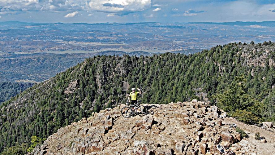
This climb ranks #1 (by a long stretch) on the Sonoma-Napa-Lake County Top 25 list with a Fiets Index of 7.23 (well beyond its closest competitors, Bald Mountain, Socrates Mine Road, and Geysers Road). The first six miles are paved (three miles on Old Lawley Toll Road and three miles on Highway 29) and average a respectable 6% which is fairly steady throughout, particularly on Highway 29. The last half of the climb is gravel and thus a gravel bike for this climb is required (I have used a Specialized Roubaix with 33mm with success). The 360 degree views at the top of Mt. St. Helena are extraordinary - the best in the North Bay. 

Mt. St. Helena is the second most scenic bike climb in the Bay Area - PJAMM's trip pages for Sonoma and Napa Counties and the Bay Area's Most Scenic climbs are viewed near the bottom of this page. 
Average grade is 6% (6.7% climb only; there are 3 short descents with the longest is 0.3 miles at -4.9%).   21% of the climb is at 0-5% and 67% at 5-10%. The steepest quarter-mile is at the end of the climb and averages 12% (but there is about 75-100 yards that are on very rough terrain at 16% - its 50/50 whether I end up walking that part).  The steepest mile on the climb is 8.8%.  7% of the climb is ≥10% grade. 

See more details and tools regarding this climb's grade via the “Profile Tool” button.
Roadway:  The first 3.2 miles on Old Lawley Toll Road are rough with debris in spots.  The 2.6 miles of roadway on Highway 29 are pristine.  The final 5.5 miles are on gravel, dirt, and rock better suited to a gravel or mountain bike. 

Traffic:  Other than the 2.6 miles on Highway 29, traffic is not an issue.  While traffic can be moderate to heavy on Highway 29, there is a wide shoulder and traffic tends to move at a reasonable speed up this windy and steep stretch of road.

Parking: There is ample parking along the vineyards at the start of the climb.  Map;  Street View
Provisions:  There are no provisions on this climb. The closest location for food and beverages is the market at the corner of Hwy 128 and Tubbs Lane 1.7 miles south of climb start (map)

Gear:  The final 5.5 miles are on gravel, dirt, and rock better suited to a gravel or mountain bike, but other than using a gravel bike once, I've used a Roubaix with 28mm to 32mm tires on this climb - the climb is fairly manageable with 32mm knobby tires. 
Before heading out on any cycling adventure check out our Things to Bring on a Cycling Trip and use our interactive check list to ensure you don't forget anything.
If you have travelled to Napa County to cycle and have any questions about climbs in the area, you are welcome to contact me at john@pjammcycling.com if you have any questions about the area.  I grew up in and live in neighboring Sonoma County, but do have a working knowledge of Napa. 

There are many wonderful boutique hotels and resorts in Napa Valley.  In addition for longer visits you can rent a private home or villa in Napa.
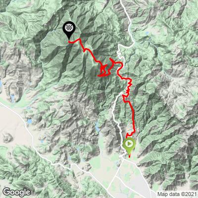
ROUTE MAP

MEMBER RATING

Difficulty: Challenging
2
Road
3
Traffic
5
Scenery

CURRENT WEATHER

PJAMM TRIPS ADVENTURE STARTER BUNDLES

Check out PJAMM Adventure's prepackaged (self-guided) cycling trips. They will help you plan, document and conquer your next adventure.
ALL TRIPS
Browse all of our prepackaged trips and find your next adventure!
San Francisco Bay Area
United States (CA)
25 ROUTES
30 POIs
ROUTE STATS (TOTAL)
487.9
mi
DISTANCE
65,482
ft
ELEV. GAIN
San Francisco Bay Area: Most Scenic Bike Climbs
United States (CA)
10 ROUTES
0 POIs
ROUTE STATS (TOTAL)
86.9
mi
DISTANCE
25,759
ft
ELEV. GAIN
Sonoma County
United States (CA)
19 ROUTES
39 POIs
ROUTE STATS (TOTAL)
269.3
mi
DISTANCE
41,801
ft
ELEV. GAIN

NEARBY CLIMBS (0) RADIAL PROXIMITY

FROM
No Climbs Found

MEMBER REVIEWS & COMMENTS

Let us know what you thought of this climb. Signup for our FREE membership to write a review or post a comment.
Already have an account?

Dec 1, 2021
difficulty: Challenging
scenery: 5
traffic: 3
road: 2
Dec 1, 2021
scenery: 5
traffic: 3
road: 2
I would rate this as one of the best summits for views in the Bay Area. The views are more expansive than Mt. Diablo and Mt. Hamilton, and only rates lower than Mt. Tam (which has SF, bay and coastal views). The climb itself is harder than any of those, due to half the climb being on dirt. I would also rate it harder than Mt. Umunhum (the hardest climb in the Bay Area rated by Fiets). Mt. Umunhum is steep in sections, but with climbing gearing and good tarmac, it is just a matter pedaling at a decent pace. The total distance, elev. gain, and road quality up Mt. St. Helena makes it a harder climb. Rolling on dirt is simply harder. Old Lawley up was car-free and easy despite debris from rains. The dirt trail up to the summit was a bit rutted and rockier from the rain as well. Gravel tires with some tread recommended. Coming down, I recommend 29 the whole way. The road was just repaved, and it isn't hard to keep pace with traffic the whole way despite the lack of shoulder.
ROUTE MAP
PROFILE TOOL
Route Data
S.G. (%)
hide
Segment Data
hide

Climb Profile Not Found
CLIMB SUMMARY

Cycling Mt. St. Helena - view of Mt. St. Helena across vineyards

Mt. St. Helena as seen from the south (Knight’s Valley).

California Top 10 Most Scenic Bike Climb

Climb summary by PJAMM’s John Johnson.

By a long stretch, Mt. St. Helena climb ranks #1 on the Sonoma-Napa-Lake County Top 25 list, with a Fiets Index of 7.23 (well beyond its closest competitors: Bald Mountain, Socrates Mine Road, and Geysers Road). The first six miles are paved (three miles on Old Lawley Toll Road and three miles on Highway 29), and averages a respectable 6% which is fairly steady throughout, particularly on Highway 29.  

Before heading to wine country on your cycling adventure, be sure to rely on our list of Things to Bring on a Cycling Trip, and use our interactive checklist to ensure you don't forget anything.

Old Lawley Toll Road Segment

3.2 miles gaining 1,060’ at 6.3%

Bike climb Mt. St. Helena - start at Old Lawley Toll Road - street, vineyards, sign 

Start on Old Lawley Toll Road.


Photo bottom Left:  Turn left onto Hwy 29 at mile 3.2

Highway 29 Segment

3.3 miles gaining 975’ at 5.1%

It can be a bit unnerving on this stretch.

Turn left onto the firetrail at mile 5.9,

Just past Robert Louis Stevenson State Park Trailhead.


The final third of the climb is on a fire road consisting of dirt and gravel, which is easily manageable for the first couple of miles on a road bike, but becomes steeper and softer/looser as you climb, being particularly difficult over a 0.2 mile 13.9% stretch just before the summit.  We have used anywhere from 28mm tires, 30t cassette with compact crankset (at a fit and youthful age 55), to 33mm knobbies with 34t chainring and 42t cassette (at an aged 62).  It is recommended that  the gravel/rock portion of this climb only be attempted on a cross or mountain bike.  

Mt. St. Helena -- Fireroad Segment

5.4 miles gaining 2,045’ at 7%

DSC05673.JPG 

Climbing wall at Mile 8, 3.5 miles from the top.

   IMG_0002.JPG

Hairpins three miles from the summit.


Traffic/Roadway Surface: 

The road is good for the first six miles, but does become dirt, gravel, and rocky over the final 5.5 miles to the summit.  There is minimal traffic on Old Lawley Toll Road, moderate traffic on Highway 29, and no traffic once you turn onto the gravel fire road.  Also please note that we are not sure if the first mile of the fire road (which we take in lieu of the hiking trail at the entrance to Robert Louis Stevenson State Park) is private  property.

All gravel for this segment

Cycling Mt. St. Helena - road to summit, radio towers, cyclist on bike on road

A very tiny cyclist on his way up the final stretch . . . 👍😅

Climb Mt. St. Helena by bike - bike on dirt road 

We suggest knobby tires for the climb.

We used 33mm knobby back, 30mm front and Specialized Roubaix.

At the top.

Cycling Mt. St. Helena - cyclist on the summit waiving with bike - DJI Mavic 2 Zoom aerial drone photo

The tiny guy made it!

View from drone looking north from the summit towards Lake County.

Cycling Mt. St. Helena - DJI Mavic 2 Pro sphere photo

Aerial Drone Sphere photo of Mt. St. Helena -- easterly view.

Aerial drone panorama -- view south towards Mt. Tamalpais and San Francisco from Mt. St. Helena Summit.

Mt. St. Helena Summit.

A Bit About the Mountain:

Mt. St. Helena was formerly known as Mount Mayacamas, as it is part of Sonoma/Napa/Lake Counties’ Mayacamas mountain range.  The mountain became known as Mt. St. Helena in 1841 after Russian surveyors left a copper plate on its summit, inscribed with the date of their visit and the name of Princess Helena de Gagarin (wife of Alexander G. Rotchev, officer of Fort Ross).  The mountain has flanks in each of Sonoma, Napa, and Lake counties.  On a clear day, Mt. Tamalpais, Mt. Diablo, and even Mt. Lassen can be seen from Mt. St. Helena’s summit (Summit Post).  Of its five peaks, the North peak is the highest, and is also highest point in Sonoma County.  Read more about Mt. St. Helena here. 

PJAMM’s New Year’s Day Challenge . . .

Mounts St. Helena, Tamalpais and Diablo in a day . . .

Sunrise Mt. St. Helena - snow on the mountain that a.m.

Of historic note, author Robert Lewis Stevenson honeymooned with his wife Fanny Vandegrift on Mt. St. Helena in 1880.  Staying in the remains of the three-story bunkhouse at what had been the Silverado mine (a site for mining gold and silver), they spent the summer along the mountainside.  From this experience, Stevenson wrote his book The Silverado Squatters, published in 1883.  Covering the area where Stevenson and Vandegrift stayed during this summer, the Robert Lewis Stevenson State Park is a popular site for locals and tourists alike.

Geodetic Survey Marker at the very top.

As early as 1878, surveyors were able to see light from Mt. Shasta’s Geodetic Monument 192 miles away at this point (Article).

MT. ST. HELENA FROM A DISTANCE

As seen from Photos from Coleman Valley Road, Occidental (top left);  Diamond Road, Calistoga (top center);

Chileno Valley Road, Petaluma (top right); Alexander Valley, Healdsburg (bottom right)

Bald Mountain, Kenwood (center); Lichau Road, Rohnert Park (bottom center);

Eastside Road, Healsburgh (bottom left).

Kortum Canyon, Calistoga (top right); Hwy 29, Calistoga (top center);

Hwy 29, Oakville (top right); Pine Flat Rd, Healdsburg (center);

Ida Clayton Rd (bottom center); Mt. Vision, Inverness (bottom left);

Photos clockwise from top left:

Sonoma Mountain Rd West; Skaggs Road, Healdsburg; River Road, Santa Rosa;

Hwy 29, Rutherford; Sky Farm, Santa Rosa; Ridgecrest Dr., Marin Co.;

Sonoma Mountain Rd. East, Glen Ellen; Spring Mountain Rd, St. Helena;


This is a special place.

Access to full Climb Summary requires a PJAMM Cycling PRO Membership!

It takes less than a minute to sign up & with your PRO membership you can:
  • Rate climbs, post comments and share your experiences on any of our climb pages
  • Create bucket lists of climbs & mark the dates you complete them
  • Weather data for all climbs - Start & Finish
  • Upload photos to your member page to customize your PJAMM Cycling experience
  • Utilize all of our interactive tools - Profile & Routes in Area
  • Download climb route .gpx files
LEARN MORE
SIGN UP

Already have an account? LOG IN HERE