
17.5
PDI
7 mi
DISTANCE
2,690 ft
GAINED
7.3 %
AVG. GRADE
FULL CLIMB STATS
INTRO
Montée Guzet-Neige climbs 11.3 km (7.0 mi) from the Ustou valley to the Guzet-Neige ski station, gaining 820 m (2690 ft) at a 7.3% average from 691 m (2267 ft) to about 1511 m (4956 ft). It ranks #240 in France and #1282 in the world in our database.
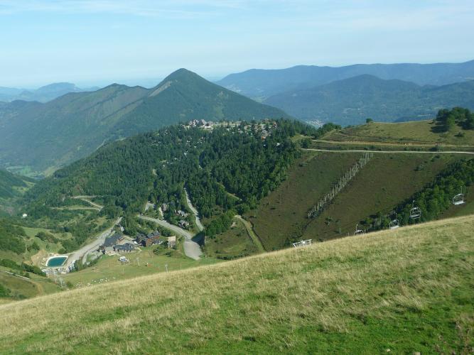
It's a steady, rhythmic climb rather than a brutal one. The first 4.8 km (3.0 mi) share the road with the western side of the Col de Latrape, climbing out of the Ustou hamlets at 7.1%. About a kilometer below the Latrape, the route turns onto the D68 - a broad road that climbs 6.5 km (4.0 mi) at 7.4% through switchbacks and a double hairpin before Guzet 1400, then on to finish among low timber chalets scattered through fir forest. One of our members found it noticeably harder once onto the ski station road, with good panoramic views at the top. It's a dead end, so you descend the way you came.
Guzet-Neige has hosted three Tour de France stage finishes: Robert Millar won here in 1984, Massimo Ghirotto in 1988 (after Philippe Bouvatier and Millar were misdirected into the press car park near the line), and Marco Pantani in 1995, finishing at 1510 m - right where this climb ends.
PLAN YOUR ROUTE
 We've partnered with Sherpa-Map.com to bring you the best route planning tool. With a PRO Membership you can use this climb as a reference when creating your route.
Montée Guzet-Neige is 11.3 km (7.0 mi) long and gains 820 m (2690 ft) at a 7.3% average, from 691 m (2267 ft) in the Ustou valley to about 1511 m (4956 ft) at Guzet-Neige.
It splits neatly into two halves of almost identical steepness. The first 4.8 km (3.0 mi), on the road toward the Col de Latrape, average 7.1%. After the turn onto the D68, the final 6.5 km (4.0 mi) to the station average 7.4%, and the last kilometer holds 7.3% right to the finish.
There are no long, sustained walls: the steepest kilometer is 10.5%, the steepest 2 km average 9.1% and the steepest 5 km 7.5%. The difficulty comes from the steady length rather than any single ramp.
Roadway: The road is paved all the way to the ski station. The D68 above the Col de Latrape turn is a broad road built for ski traffic, with sweeping switchbacks and a double hairpin before Guzet 1400. Near the top, a 2 km (1.2 mi) side road branches off to the Col d'Escot (1618 m / 5308 ft) - only worth the detour if its surface looks good on the day. Snow affects the upper road in winter and spring, so check Ariège's Inforoute09 road information before riding outside summer.
Traffic: Traffic is light outside the ski season. The D68 is a dead end serving only the station, and the lower road toward the Col de Latrape is a quiet mountain route. Expect more cars on winter weekends, when the station is open.
Parking: The Ustou hamlets are small, so park considerately in Sérac d'Ustou or nearby Saint-Lizier d'Ustou. The longer, classic version of the climb starts down the valley in Seix, so parking there and riding up the Ustou valley also makes a good warm-up. At the top, Guzet-Neige has free parking at every level of the station, including the Prat Mataou car park at 1518 m (4980 ft), right by the finish.
Gear: With no sustained pitch much above 10%, a compact with a 28- or 30-tooth cog is plenty for most riders. The finish is over 1500 m (4921 ft), more than 800 m (2625 ft) above the valley, so pack a wind layer for the descent even in summer.
Provisions: Seix, down the valley, is the best place to stock up, with shops and restaurants. The ski station's restaurant and services are geared to the winter season, so don't count on finding anything open at Guzet in summer.
Before heading out on any cycling adventure check out our Things to Bring on a Cycling Trip and use our interactive check list to ensure you don't forget anything.
Guzet-Neige is one of the Pyrenees' more unusual ski stations: instead of apartment blocks, it's a scatter of small timber chalets in a fir forest on a knoll with a 360-degree view. It has three sectors - Guzet 1400, the village center and front de neige; Prat Mataou, a chalet quarter on a high plateau near this climb's finish; and the steeper Freychet sector, with lifts reaching around 2100 m (6890 ft).
In summer, the Guzet Express rail toboggan runs more than 1.5 km (0.9 mi) down the mountain with a 357 m (1171 ft) drop, through four tunnels and over a footbridge - a fun post-ride outing if it's running (it closes in rain, and booking opens in early July). Down in the valley, the château in Seix houses a heritage interpretation center.
Over the Col de Latrape, the road drops to the spa village of Aulus-les-Bains, the start of our Col d'Agnes climb. Guzet's summit finish is well above the valley, so check current conditions before you go with our Weather tool.
ROUTE MAP

MEMBER RATING
CURRENT WEATHER
PJAMM TRIPS ADVENTURE STARTER BUNDLES
Check out PJAMM Adventure's prepackaged (self-guided) cycling trips. They will help you plan, document and conquer your next adventure.
NEARBY CLIMBS (0) RADIAL PROXIMITY
FROM No Climbs Found
MEMBER REVIEWS & COMMENTS
Let us know what you thought of this climb. Signup for our FREE membership to write a review or post a comment.
Already have an account?
LOG IN HERE
carlinguernsey
This is a challenging addition to one (or both) of the sides of the Col de Latrape. The climb seemed a bit more difficult once onto the actual road to the ski station. There are some good panoramic views at the top.
