
17.8
PDI
5.9 mi
DISTANCE
2,514 ft
GAINED
8.1 %
AVG. GRADE
FULL CLIMB STATS
INTRO
PLAN YOUR ROUTE
 We've partnered with Sherpa-Map.com to bring you the best route planning tool. With a PRO Membership you can use this climb as a reference when creating your route.
The climb covers 9.4 km (5.9 mi) and gains 766 m (2514 ft) at an 8.1% average. The steepest kilometer averages 11.9%, the steepest 2 km 10.2% and the steepest 5 km 8.1%, and the steepest 500 m reaches 16.6%.
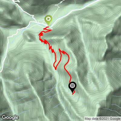
The first 4 km (2.5 mi) are steady at 8-9% as the D208 climbs away from the valley. Around Goulier (about km 5) the grade drops to roughly 5% for a kilometer - the only real respite. From there it's 6-8% through the middle section, and the final kilometer to the station is the steepest of the climb at close to 12%.
Roadway: The D208 is paved all the way to the station, and riders describe the surface as in good condition, though the road is narrow in places with many tight hairpins. On the way down, watch for loose gravel on the bends and, in autumn, fallen leaves in the hairpins. Snow can affect the upper road in winter, so check Ariège's Inforoute09 road information before riding outside summer.
Traffic: Very light. The D208 is a dead end serving Goulier and the ski area, so outside the ski season you'll likely see more cyclists than cars.
Parking: Vicdessos is a small village, so park considerately in the center - the arcaded Place des Arcades, home to the tourist information office, is the heart of town - and roll a few hundred meters to the start. At the top, the ski station has a free car park, useful if someone is meeting you.
Gear: With 8-9% for long stretches and a final kilometer near 12%, a compact crankset with a 30- to 32-tooth cog is the comfortable choice. The finish is more than 750 m (2461 ft) above the valley floor, so pack a light wind layer for the descent.
Provisions: There's nothing to buy on the climb, and you shouldn't count on the ski station for food outside the ski season. Fill bottles at the fountain in front of the post office in Vicdessos, and top up at the water tap on a bend at the entrance to Goulier.
Before heading out on any cycling adventure check out our Things to Bring on a Cycling Trip and use our interactive check list to ensure you don't forget anything.
Vicdessos is the main village of Val-de-Sos, a commune created in 2019 when Vicdessos merged with Sem, Goulier and Suc-et-Sentenac. For centuries the valley lived from iron: the Rancié mine above Sem is mentioned in texts from 1294 and only officially closed in 1931, and Goulier supplied many of its miners. A free exhibition on the mine is run from the mairie in Sem, open in July and August in the afternoon or by appointment the rest of the year - a short detour from Vicdessos.
In Vicdessos itself, the 17th-century church of Notre-Dame and the arcaded central square are worth a look, and the Maison des Patrimoines in neighboring Auzat covers the valley's iron and aluminium industries, pastoralism and archaeology. Goulier, today home to around 45 people, has medieval origins, and the larches you ride through were planted in an organized reforestation after centuries of heavy logging. Vicdessos is also the start of our Port de Lers climb, and Col d'Agnes lies just beyond it, so a big Ariège day is easy to string together.
ROUTE MAP
MEMBER RATING
CURRENT WEATHER
PJAMM TRIPS ADVENTURE STARTER BUNDLES
Check out PJAMM Adventure's prepackaged (self-guided) cycling trips. They will help you plan, document and conquer your next adventure.
NEARBY CLIMBS (0) RADIAL PROXIMITY
FROM No Climbs Found
MEMBER REVIEWS & COMMENTS
Let us know what you thought of this climb. Signup for our FREE membership to write a review or post a comment.
Already have an account?
LOG IN HERE
