
18.5
PDI
6.2 mi
DISTANCE
2,688 ft
GAINED
7.8 %
AVG. GRADE
FULL CLIMB STATS
INTRO
PLAN YOUR ROUTE
 We've partnered with Sherpa-Map.com to bring you the best route planning tool. With a PRO Membership you can use this climb as a reference when creating your route.
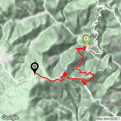
Ragonà is 9.9 km (6.2 mi) long and climbs 819 m (2,688 ft) at an average of 7.8%, from 433 m (1,420 ft) to 1,197 m (3,927 ft). There are about 55 m (181 ft) of descent along the way.
The climb opens with its hardest sustained start: km 1 averages about 11.7% and km 2 about 9.7%. Kilometers 3 and 4 settle to roughly 7.5%, and km 5 offers a brief breather at around 4%. Then the second wall arrives: km 6 at about 8%, km 7 at about 12.7% and km 8 at about 8.6%. The final 2 km (1.2 mi) ease to under 4% as the road reaches the SP88.
Steepest sections: 100 yards (91 m) at 21.2%, 0.5 km (0.3 mi) at 15.2%, 1 km (0.6 mi) at 14.0%, 2 km (1.2 mi) at 10.8% and 5 km (3.1 mi) at 8.1%.
Roadway: Paved throughout. This is a narrow, winding rural road for most of its length before it joins the SP88 near the top, with tight hairpins on the steepest pitches and the patched, uneven asphalt typical of minor mountain roads in Calabria. The SP88 area is prone to landslides and rockfall after heavy rain, so descend with care and check with the Provincia di Vibo Valentia or the Città Metropolitana di Reggio Calabria after storms - the finish sits close to the border between the two provinces.
Traffic: Very light. The lower road serves only the scattered hamlets of the Nardodipace and Caulonia hinterland, and the upper SP88 is a quiet forest road.
Parking: Ragonà is a tiny hamlet with no car park, so leave the car considerately on a wide shoulder, well clear of farm and house access. Our Nardodipace page starts from the same spot. The finish has no facilities either, so plan to ride back down the way you came or continue along the SP88.
Provisions: There are no shops or cafes on the climb, so bring everything with you and fill bottles before you leave your base. The lower slopes are exposed and can be very hot in summer, while the forested top is far cooler.
Gear: Low gears are essential. With a 15.2% steepest half kilometer and short ramps above 20%, a compact crankset with a 32- or 34-tooth cassette is the sensible minimum. Pack a layer for the descent, which drops more than 750 m (2,461 ft).
Before heading out on any cycling adventure check out our Things to Bring on a Cycling Trip and use our interactive check list to ensure you don't forget anything.
The Allaro river you climb out of also flows past Mongiana, higher in the Serre to the north. In 1761-62 the Bourbon kingdom built an ironworks there above the Allaro, and by the early 19th century it was the largest in Italy, turning out weapons for the royal army and rails for the first railway in the Kingdom of the Two Sicilies. The works closed in the 1870s, and since 2013 the former armoury has housed MuFar, the Museum of the Royal Bourbon Ironworks, with a path leading on to the old foundries, blast furnaces and iron mines. It is the best rest-day visit in this part of the Serre.
Closer to the start, Nardodipace's new village on the Ciano plateau has a church decorated with majolica works by the sculptor Pietro Cascella. For the old village, its September 8 feast and the local megalith sites, see our Nardodipace page; for the Ionian coast and Caulonia's old town, see our Caulonia page. To find more climbs around the Serre or plan a route from here, use our Routes in the Area tool.
ROUTE MAP
MEMBER RATING
CURRENT WEATHER
PJAMM TRIPS ADVENTURE STARTER BUNDLES
Check out PJAMM Adventure's prepackaged (self-guided) cycling trips. They will help you plan, document and conquer your next adventure.
NEARBY CLIMBS (0) RADIAL PROXIMITY
FROM No Climbs Found
MEMBER REVIEWS & COMMENTS
Let us know what you thought of this climb. Signup for our FREE membership to write a review or post a comment.
Already have an account?
LOG IN HERE
