
19
PDI
7.2 mi
DISTANCE
2,882 ft
GAINED
7.6 %
AVG. GRADE
FULL CLIMB STATS
INTRO
Lagoa do Fogo is the signature climb of São Miguel, the largest island in the Azores. From the waterfront town of Lagoa, the road climbs 11.5 km (7.2 mi) and 878 m (2882 ft) at an average of 7.6%, from almost sea level to 885 m (2904 ft) on the rim of the Fogo volcano - from the ocean to a crater lake in one unbroken climb.
The opening 3 km through Lagoa and Santa Cruz are gentle, but from there the road heads straight up the volcano's south slope and averages more than 9% for the remaining 8.5 km (5.3 mi), through the lush green countryside the Azores are famous for. The views back over the Atlantic coast grow with every switchback.
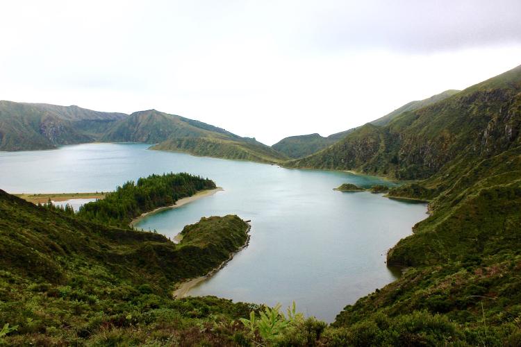
At the top, the road crests beside Pico da Barrosa, one of the highest points on the island, and the lake viewpoints are just beyond. Lagoa do Fogo itself sits in a caldera formed about 15,000 years ago, and has been a protected nature reserve since 1974. Cloud can swallow the whole mountain in minutes, so check current conditions before you go with our Weather tool.
PLAN YOUR ROUTE
 We've partnered with Sherpa-Map.com to bring you the best route planning tool. With a PRO Membership you can use this climb as a reference when creating your route.
Lagoa do Fogo from Lagoa climbs 11.5 km (7.2 mi) from 8 m (27 ft) to 885 m (2904 ft), gaining 878 m (2882 ft) at an average grade of 7.6%.
The first 3 km (1.9 mi) are a warm-up at about 2.5-3.5% as you leave town. After that the climb is relentless: km 4 averages 8.1%, km 5 8.9% and km 6 10.2%, then three straight kilometers at about 8.5% before the hardest section near the top, where km 10 averages 11.6% and km 11 10.1%.
The steepest kilometer averages 11.6%, the steepest half kilometer 13.3%, the steepest 2 km 10.7% and the steepest 5 km 9.6%. Once the road turns uphill after km 3, it averages 9.2% to the finish.
Roadway: Paved the whole way, on town streets through Lagoa and Santa Cruz and then the regional mountain road (EN5-2A) that links Lagoa with Ribeira Grande over the Fogo massif. The surface is generally good, with plenty of curves near the top. Expect damp, slippery patches when cloud sits on the mountain, which is often.
Traffic: Light on the lower slopes but busy near the lake, one of the island's top attractions, with cars parked along the road at the viewpoints. In recent summers (mid-June through September), car access on the upper road between the Casa da Água and Caldeira Velha car parks has been restricted during the day, with shuttle buses carrying most visitors to the lake - fewer private cars, but regular buses to share the road with.
Parking: The climb starts in the town of Lagoa, where street parking around the center and the waterfront is the easiest option. To start higher and skip the town, the route passes Casa da Água, the southern shuttle car park, at around km 5 - it can be busy in summer.
Gear: A compact chainset with a 30 or 32 tooth cog makes the long stretch at 9-11% much more pleasant. Carry a rain jacket and a warm layer even on a sunny day - the finish is close to 900 m (2950 ft) and frequently wrapped in cloud, wind and drizzle, so the descent can be cold and wet. Lights are worth having in fog.
Provisions: Lagoa has cafes and shops, so fill up before you start - there are no services on the mountain road above town.
Before heading out on any cycling adventure check out our Things to Bring on a Cycling Trip and use our interactive check list to ensure you don't forget anything.
Lagoa is a pleasant base just east of Ponta Delgada, the island's main city. Cerâmica Vieira, founded in 1862 and still run by the same family, lets you watch its traditional pottery and tiles being made, and the town is also home to the Azores Volcanological and Geothermal Observatory - a good way to understand the volcano you just climbed. After the ride, cool off in Lagoa's natural seawater pools, or head east to Caloura's rock pools on the coast below Água de Pau.
At the top, the main viewpoint over the lake is a short ride beyond the finish, and a paved path leads up to Pico da Barrosa. Hiking down to the lakeshore itself takes a couple of hours each way. Go early: mornings give the best chance of clear views, and cloud often rolls in by late morning. Continuing over the top and down the north side brings you to the thermal pools at Caldeira Velha, outside Ribeira Grande.
ROUTE MAP

MEMBER RATING
CURRENT WEATHER
PJAMM TRIPS ADVENTURE STARTER BUNDLES
Check out PJAMM Adventure's prepackaged (self-guided) cycling trips. They will help you plan, document and conquer your next adventure.
NEARBY CLIMBS (0) RADIAL PROXIMITY
FROM No Climbs Found
MEMBER REVIEWS & COMMENTS
Let us know what you thought of this climb. Signup for our FREE membership to write a review or post a comment.
Already have an account?
LOG IN HERE
Andrew


Amazing ride with stunning views of the ocean and Lago do Fogo (Fire Lake).
