
18.6
PDI
8.7 mi
DISTANCE
3,033 ft
GAINED
6.7 %
AVG. GRADE
FULL CLIMB STATS
INTRO
PLAN YOUR ROUTE
 We've partnered with Sherpa-Map.com to bring you the best route planning tool. With a PRO Membership you can use this climb as a reference when creating your route.
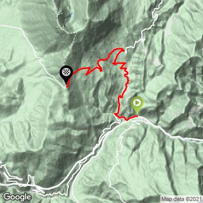
The climb averages 6.7% over 13.9 km (8.7 mi), but it saves its hardest work for last. The first 2 km (1.2 mi) out of Trisungo are a gentle warm-up at around 5%, then the road settles into a steady 6-7.5% through Piedilama and up to Pretare at roughly 7 km (4.3 mi). After a slightly easier stretch to the turn toward Castelluccio at about 8 km (5.0 mi), the final 5.9 km (3.7 mi) average about 7.5% and keep getting steeper, with the last 2 km (1.2 mi) close to 9%.
The steepest 0.5 km averages 10.2%, the steepest kilometer 9.8%, the steepest 2 km 9.2% and the steepest 5 km 7.7% - all of them in the upper part of the climb, along the Vettore wall.
Roadway: The road is paved the entire way, following the SP129 from Trisungo, the SP89 Valfluvione through Pretare and the SP34 up to the pass. It's a narrow mountain road, and riders have reported it in regular use from late spring through early autumn 2026. Snow closes the pass in winter, sometimes for days at a time - it was shut for three days after heavy snowfall in late December 2024 - so check the Provincia di Ascoli Piceno's road notices before an early- or late-season ride.
Traffic: Light below Pretare, where the road mainly serves the valley's hamlets. It picks up on summer weekends, when hikers drive up to the trailheads for Monte Vettore and Lago di Pilato, and especially during the Castelluccio flowering (the Fiorita) from mid-June into July, when access to the Pian Grande is often managed with gated parking and shuttle buses on peak days.
Parking: Most riders start from Trisungo or Arquata del Tronto along the SS4 Salaria in the Tronto valley - park considerately in the village rather than at the junction itself. The pass is a popular trailhead, and on busy summer weekends cars line the road near the top.
Provisions: Stock up in the Tronto valley before you start. The Rifugio degli Alpini "G. Giacomini" at the pass has been closed since the 2016 earthquake (its operators run a temporary facility down in Pretare), so don't count on food or water at the top. Two bottles are a good idea in summer, since the final 5 km (3.1 mi) are fully exposed.
Gear: Standard compact gearing handles most of the climb, but save something for the last 2 km (1.2 mi), which approach 9-10%. The pass sits at 1533 m (5,031 ft) on an open ridge beneath Monte Vettore, so pack a wind layer for the descent even on a warm day, and an extra layer in spring and autumn.
Before heading out on any cycling adventure check out our Things to Bring on a Cycling Trip and use our interactive check list to ensure you don't forget anything.
Arquata del Tronto is the only comune in Italy that lies within two national parks - the Monti Sibillini to the north and the Gran Sasso e Monti della Laga to the south - and its medieval Rocca, locally called the castle of Queen Giovanna, still watches over the Salaria. Pretare, which you ride through at about 7 km (4.3 mi), is tied to the legend of the Sibyl's fairies, said to have danced with the local youths until nearly dawn and left their footprints as the path across Monte Vettore as they fled; a play based on the story is staged in the village every August.
At the top, Forca di Presta is the trailhead for the hikes to Monte Vettore's summit and Lago di Pilato, and the easy Sentiero per Tutti, about 3 km (1.9 mi) through the meadows to a viewpoint over the Laga mountains, is a good option for non-riding companions. Over the pass lie the Pian Grande and the hilltop village of Castelluccio di Norcia, famous for its lentils and its summer flowering, and Forca di Gualdo, the plateau's northern gateway, makes a natural partner climb. Lodging in the area is still limited after the earthquake, so book ahead.
ROUTE MAP
MEMBER RATING
CURRENT WEATHER
PJAMM TRIPS ADVENTURE STARTER BUNDLES
Check out PJAMM Adventure's prepackaged (self-guided) cycling trips. They will help you plan, document and conquer your next adventure.
NEARBY CLIMBS (0) RADIAL PROXIMITY
FROM No Climbs Found
MEMBER REVIEWS & COMMENTS
Let us know what you thought of this climb. Signup for our FREE membership to write a review or post a comment.
Already have an account?
LOG IN HERE
