Spring Mountain Road Bike Climb - PJAMM Cycling

10.8
PDI
4 mi
DISTANCE
1,638 ft
GAINED
7.7 %
AVG. GRADE

FULL CLIMB STATS

INTRO

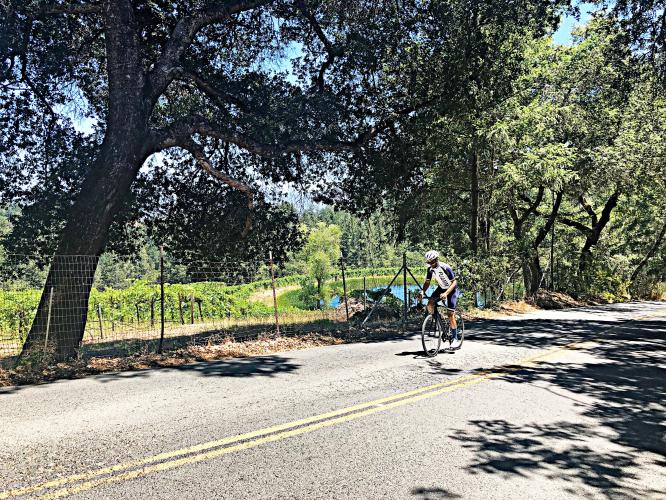
This is the hardest fully paved bike climb in Napa County.  The first couple miles of the climb are generally shaded under a canopy of trees. Just past two miles, we encounter a very sharp left turn and the road pitches up dramatically for most of the remaining second half of the climb - 1.9 miles, 1,100' at 11.2% average grade. This is a beautiful climb - the first several miles are rural and wooded, while the steeper last half treats us to classic Napa County hillside vineyards, quite spectacular in the spring and summer - truly some of the best vineyard-climb views in Napa County. Make sure to save some energy as this climbs is deceptive and very easy to 'blow up' on. Though it is shady it can be very hot in the summer and often has cars so be mindful when descending. 

PLAN YOUR ROUTE

We've partnered with Sherpa-Map.com to bring you the best route planning tool. With a PRO Membership you can use this climb as a reference when creating your route.
7.8% average grade (8.2% climb only).  This climb has a full spectrum of gradients - 4% is descent, 27% is at 0-5%, 31% is at 5-10/%, 31% is at10-15%, and 6.4% is at 15-20% grade.  The steepest quarter-mile is 14.9% and there is a full half-mile that averages 14.1%.  

See more details and tools regarding this climb's grade via the “Profile Tool” button.
Roadway:  Two lane with center stripe in rough condition. There is no shoulder on this route.

Traffic:  Light.

Parking:  Park along Hillview Place adjacent to the middle school, one-half mile from climb start - Map; Street View
Provisions:  There are many places to eat and get food in St. Helena within a mile of the beginning of the climb (Google Map - Where to eat in St. Helena).  I am a big fan of The Model Bakery on Main Street, 8/10ths of a mile from the climb start (MapStreet View) - you can get lunch and breakfast here.
Before heading out on any cycling adventure check out our Things to Bring on a Cycling Trip and use our interactive check list to ensure you don't forget anything.
If you have travelled to Napa County to cycle, you are welcome to contact me at john@pjammcycling.com if you have any questions about the area.  I grew up and live in neighboring Sonoma County, but do have a good working knowledge of Napa.

Use the “Routes in Area” button on the menu bar to see other bike climbs in this area.

ROUTE MAP

MEMBER RATING

Not Yet Rated
-
Road
-
Traffic
-
Scenery

CURRENT WEATHER

PJAMM TRIPS ADVENTURE STARTER BUNDLES

Check out PJAMM Adventure's prepackaged (self-guided) cycling trips. They will help you plan, document and conquer your next adventure.
ALL TRIPS
Browse all of our prepackaged trips and find your next adventure!
Sonoma County
United States (CA)
19 ROUTES
39 POIs
ROUTE STATS (TOTAL)
269.3
mi
DISTANCE
41,801
ft
ELEV. GAIN

NEARBY CLIMBS (0) RADIAL PROXIMITY

FROM
No Climbs Found

MEMBER REVIEWS & COMMENTS

Let us know what you thought of this climb. Signup for our FREE membership to write a review or post a comment.
Already have an account?
ROUTE MAP
PROFILE TOOL
Route Data
S.G. (%)
hide
Segment Data
hide
CLIMB SUMMARY

Mt. St. Helena - Aerial drone photo from the top of Spring Mountain

This climb ranks #8 on the Tri-County Top Climb list with Fiets Index of 4.0. The first couple miles of  the climb are generally shaded under a canopy of trees.  Just past 2 miles, we encounter a  very sharp left turn and the road pitches up dramatically for most of the remaining second half of the  climb -  1.9 miles, 1,100' at 11.2% average grade.  This is a beautiful climb - the first several miles are  rural and wooded, while the steeper last half treats us to classic Napa County hillside vineyards,  quite spectacular in the spring and summer - truly some of the best vineyard-climb views  in Napa County.  

Bike climb Spring Mountain Road - Spring Mountain Road sign with cyclist riding by   

Bicycle ride Spring Mountain Road - share the road sign

DSC03871.JPG

  Cycling Spring Mountain Road - PJAMM Tayler Hocket riding bike on road past pond and vineyards


This climb can be broken into 2 separate ascents, Spring Mountain #1 (2.2 miles / 532' / 4.2%  average grade)  and Spring Mountain #2 (1.9 miles / 1,100 / 11.2% average grade).

Traffic/Roadway surface:  The road is wide with a bike lane much of the way and the surface is  excellent.  Traffic is mild to moderate.

Spring Mountain Road - aerial drone panorama photo of Napa Valley and Mt. St. Helena

Mt. St. Helena and northern Napa Valley - aerial drone pano from the top of Spring Mountain.