15
PDI
8.6 mi
DISTANCE
2,703 ft
GAINED
5.9 %
AVG. GRADE
FULL CLIMB STATS
Page Contributor(s): Ron Hawks, Las Vegas, NV; Luke Hise, Phoenix, AZ; Erich Pawelka, Vienna, Austria
INTRO
"A very isolated ascent, Eldorado Canyon located southeast of Las Vegas rises up from the Colorado River canyon through dazzling and stark desert terrain. There used to be a boat dock at the end of the drainage where you start the ascent. A flash flood wiped it out (along with 8 people unfortunately) back in the 1970s and it was never rebuilt. The first section of climbing is over moderate slope. After 0.2 miles turn left to continue to climb over more shallow grade which tends to gradually steepen. Interesting desert views of rugged mountains ahead of you appear on this stretch. After just under 2.5 miles the road begins to enter a canyon and you will notice hoodoos in the drainage to your left..." (This quote is presented with the approval of John Summerson, from his book, The Complete Guide to Climbing (by Bike), 2nd Edition, pg. 199.)
PLAN YOUR ROUTE
See more details and tools regarding this climb's grade via our interactive Profile Tool.
Information Not Available
If you have any information regarding this climb, we'd like to hear from you. Click the CONTRIBUTE button to share your thoughts with us.
Information Not Available
If you have any information regarding this climb, we'd like to hear from you. Click the CONTRIBUTE button to share your thoughts with us.
Before heading out on any cycling adventure check out our Things to Bring on a Cycling Trip and use our interactive check list to ensure you don't forget anything.
Information Not Available
If you have any information regarding this climb, we'd like to hear from you. Click the CONTRIBUTE button to share your thoughts with us.
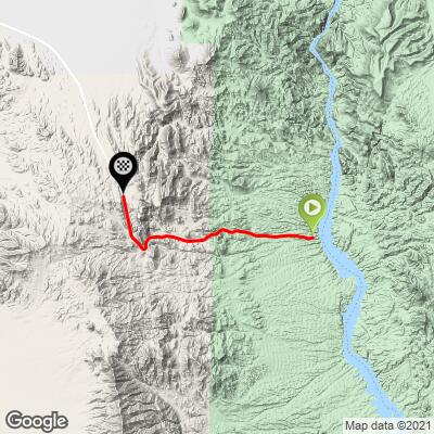
ROUTE MAP
MEMBER RATING
CURRENT WEATHER
PJAMM TRIPS ADVENTURE STARTER BUNDLES
Check out PJAMM Adventure's prepackaged (self-guided) cycling trips. They will help you plan, document and conquer your next adventure.
NEARBY CLIMBS (0) RADIAL PROXIMITY
FROM No Climbs Found
MEMBER REVIEWS & COMMENTS
Let us know what you thought of this climb. Signup for our FREE membership to write a review or post a comment.
Already have an account?
LOG IN HERE
KaktusJaque


I parked in the parking area right off US 95 where State 165 starts. From there it's apx 9.5 miles up to the top with about an avg 4% grade. Views are ok during this part but get much better after the top. Then it's all downhill to Nelson's Landing where there are awesome views of the starking contrast of the Mohave Desert and the Blue waters of the Colorado River. Head back up for apx 8.5 miles of avg. grade of 5.8% with some 7s and 9s mixed in. Notable photo op stops, natural rock towers, Nelson Ghost Town tourist trap and the Colorado River. I encountered a lot of wind on my descents. In some cases, pedaling to keep my speed up. Strong winds can be common in this region of NV. I would consider doing this ride again. It has some good gains and is not all that far from Vegas. It's a good ride to do in the cooler months. I would not recommend this in the summer months though. There were some gravel trucks, & tourists going to the ghost town, not much between town and the landing.
hiseluke
Road: Some minor washboard effect on the decent and minimal to non existent shoulder. On the ascent, the road is fine.
Traffic: The only traffic will be people going to the boat ramp on the Colorado River, folks paying a visit to the "ghost town", or big trucks coming to/from an active quarry. Trucks were respectful and I felt safe. Maybe a total of 6 cars?
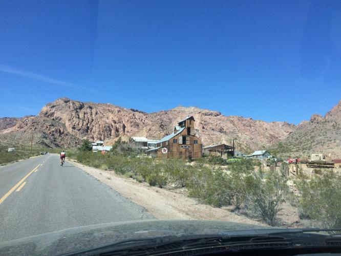
Scenery: The approach to the river is classic desert Red Rocks esque mountains abutting the water. The ghost town is a collection of wrecked vehicles, planes, boats, autos, and machinery. If you ever wanted to see an A-10 Warthog buried nose down in the desert, you have come to the right place.