
18.9
PDI
9.4 mi
DISTANCE
3,210 ft
GAINED
6.4 %
AVG. GRADE
FULL CLIMB STATS
INTRO
PLAN YOUR ROUTE
 We've partnered with Sherpa-Map.com to bring you the best route planning tool. With a PRO Membership you can use this climb as a reference when creating your route.
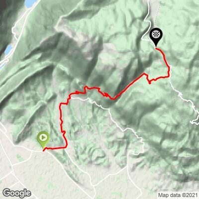
La Crosetta climbs 15.1 km (9.4 mi) and gains 978 m (3,210 ft) at an average of 6.4%, from 134 m (439 ft) in Anzano to 1099 m (3,607 ft) at the top.
The climb has two phases. The first 2 km (1.2 mi), from Anzano to Fratte, are a gentle approach at around 2-4%. From there the road settles into a long, steady grind - roughly 13 km (8.1 mi) at close to 7% - with most kilometers between 7% and 8.5% and only the final 2 km easing slightly as the forest opens toward the saddle.
The steepest kilometer averages 8.8%, the steepest 2 km (1.2 mi) 8.3%, the steepest 5 km (3.1 mi) 7.8% and the steepest 10 km (6.2 mi) 7.5%. The steepest 500 m (0.3 mi) averages 9.4%, and the steepest 100 m pitch reaches 10.4%.
Roadway: The route is paved the entire way, following village streets from Anzano through Fratte and Fregona before joining Via del Cansiglio for the long forested climb to the pass. The upper road is narrower and largely unmarked through the forest, but riders consistently describe it as good asphalt. Snow and ice can linger on the shaded upper kilometers in winter and early spring, so check conditions before an off-season ride.
Traffic: Expect some local traffic through Cappella Maggiore and Fregona, plus day-trippers heading up to the Cansiglio on summer weekends. On weekdays outside high summer, the upper road through the forest is often close to empty.
Parking: Most riders start from Cappella Maggiore or Fregona, both working villages a short drive from Vittorio Veneto and the A27 motorway. If you'd rather skip the flat opening 2 km, Fregona puts you right at the foot of the real climbing.
Provisions: Stock up in Cappella Maggiore or Fregona - once you leave the villages behind, there's nothing until the summit, where La Crosetta has a fountain with fresh mountain water and a small bar.
Gear: Standard road gearing works, but 13 km at close to 7% rewards a compact crank and a 30- or 32-tooth low cog. The start sits barely above sea level and the finish is over 1000 m (3,281 ft), so the descent through the shaded forest can be much cooler than the plain - carry a gilet or light jacket.
Before heading out on any cycling adventure check out our Things to Bring on a Cycling Trip and use our interactive check list to ensure you don't forget anything.
Fregona, the village where the real climbing begins, is home to the Grotte del Caglieron - a gorge cut by the Caglieron stream, lined with waterfalls and with man-made caverns left by quarrying of the soft "pietra dolza" sandstone from the 16th century onward. The caves were later used to age cheese and grow mushrooms, one holds a small church, and a wooden walkway of about 1 km (0.6 mi) runs through the whole ravine. It's a cool, short visit on a hot day, open most of the year.
Over the top, the Pian del Cansiglio plateau is worth exploring on the bike - its beech forest was managed for centuries by Venice as a source of oar wood. For other climbs nearby, including the Muro di Ca' del Poggio and Passo San Boldo, use our Routes in the Area tool.
ROUTE MAP
MEMBER RATING
CURRENT WEATHER
PJAMM TRIPS ADVENTURE STARTER BUNDLES
Check out PJAMM Adventure's prepackaged (self-guided) cycling trips. They will help you plan, document and conquer your next adventure.
NEARBY CLIMBS (0) RADIAL PROXIMITY
FROM No Climbs Found
MEMBER REVIEWS & COMMENTS
Let us know what you thought of this climb. Signup for our FREE membership to write a review or post a comment.
Already have an account?
LOG IN HERE
