
19.3
PDI
9.7 mi
DISTANCE
3,282 ft
GAINED
6.4 %
AVG. GRADE
FULL CLIMB STATS
INTRO
PLAN YOUR ROUTE
 We've partnered with Sherpa-Map.com to bring you the best route planning tool. With a PRO Membership you can use this climb as a reference when creating your route.
The climb averages 6.4% over 15.7 km (9.7 mi), gaining 1000 m (3282 ft). The steepest 500 m averages 12.0%, the steepest 1 km 11.5%, the steepest 2 km 9.9%, the steepest 5 km 8.5% and the steepest 10 km 7.6%.
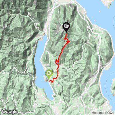
The first 2 km (1.2 mi) from Legro to Miasino average 7.2%, followed by 3 km (1.9 mi) at only 2.1% through Armeno. From Armeno the SP41 gets serious: the next 5 km (3.1 mi) average 8.5%, with the steepest pitch just above Armeno near Cheggino. The grade then eases to 4.6% for 2 km (1.2 mi) before the final 3.7 km (2.3 mi) climb at 7.5% to the finish.
Roadway: The route is paved throughout. It leaves Legro on the SP39 delle Due Riviere through Miasino to Armeno, then follows the SP41 up the Mottarone through pine and birch woods and old alpine pastures, with a couple of hairpins near the top. The private, tolled Strada Borromeo is on the Stresa side of the mountain - this approach uses the provincial SP41.
Traffic: The lower roads through Miasino and Armeno carry local traffic. The restaurants, hotels and attractions around the top are reached by car, so expect more traffic on fine weekends, especially in summer.
Parking: The Orta San Giulio railway station at Legro has a large car park right at the start of the climb. Armeno's Piazza della Vittoria, opposite the town hall, has a fountain and a bar, and is a good place to regroup before the steep section.
Provisions: Water is available at the fountain or bar in Armeno's Piazza della Vittoria, at the Luciago fountain (check that it is marked drinkable) and at the Alpini fountain, a few hundred meters past Alpe Frimm near the top. There are several restaurants on the Mottarone.
Gear: With 5 km (3.1 mi) at 8.5% and short ramps above 12%, a compact with a 30 or 32 tooth largest cog is a comfortable choice.
Weather: The finish is nearly 1000 m (3300 ft) above Lake Orta. Pack a layer for the descent, and in summer start early to avoid the heat on the lower slopes.
Before heading out on any cycling adventure check out our Things to Bring on a Cycling Trip and use our interactive check list to ensure you don't forget anything.
Orta San Giulio is one of the loveliest bases in the Italian lakes. Take a boat across to the Isola San Giulio and walk up to the Sacro Monte di Orta above town. Legro, at the start of the climb, is known as a painted village for the murals on its walls.
On the way up, Armeno's Romanesque church of Santa Maria Assunta sits right on the route, and near the top the road passes the monument to the champions Piemontesi and Fornara. If you descend toward Lake Maggiore on the Strada Borromeo, Gignese's Umbrella Museum makes an unusual stop. Bike hire is available in Orta San Giulio and Miasino.
ROUTE MAP
MEMBER RATING
CURRENT WEATHER
PJAMM TRIPS ADVENTURE STARTER BUNDLES
Check out PJAMM Adventure's prepackaged (self-guided) cycling trips. They will help you plan, document and conquer your next adventure.
NEARBY CLIMBS (0) RADIAL PROXIMITY
FROM No Climbs Found
MEMBER REVIEWS & COMMENTS
Let us know what you thought of this climb. Signup for our FREE membership to write a review or post a comment.
Already have an account?
LOG IN HERE
