
21.1
PDI
6.2 mi
DISTANCE
2,823 ft
GAINED
8.7 %
AVG. GRADE
FULL CLIMB STATS
INTRO
PLAN YOUR ROUTE
 We've partnered with Sherpa-Map.com to bring you the best route planning tool. With a PRO Membership you can use this climb as a reference when creating your route.
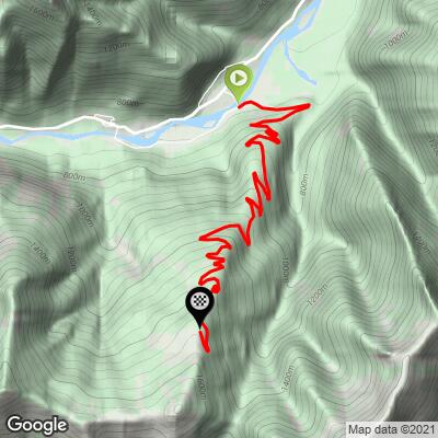
 The climb averages 8.7% over 9.9 km (6.2 mi), gaining 860 m (2,823 ft) from Chioso at 659 m (2,163 ft) to Alpe di Mera at 1,519 m (4,985 ft).
There are few places to recover. The steepest 91 m (100 yd) is 13.7%, the steepest 500 m 11.9%, the steepest kilometer 11.6% and the steepest 2 km 11.2%. The steepest 5 km (3.1 mi) averages 10.0%, which leaves the other 4.9 km (3.0 mi) averaging about 7.4%.
Even over a longer stretch the grade stays high - the steepest 8.0 km (5 mi) averages 9.3% - and there is almost no descending along the way.
Roadway: The road is paved the whole way from Chioso to Alpe di Mera. The lower slopes are in decent shape, but higher up the asphalt gets rougher and riders report potholes on the upper road (particularly around Trogo), so take care on the descent. Alpe di Mera is a ski area, so expect snow and ice on the upper road from late autumn into spring.
Traffic: Light. This is the access road to the Alpe di Mera ski area and the mountain houses along the way, so you will mostly share it with locals and visitors heading for the ski area and the hiking trails.
Parking: Scopello is the natural base and has plenty of parking in the village, with the climb starting at Chioso on the edge of town. There are also parking areas along the road up to Alpe di Mera, the first roughly halfway up, if you only want to ride the upper half.
Gear: With an 8.7% average and long stretches at 10% or more, bring compact gearing and a wide-range cassette. Standard road tires are fine on the paved road, but ride the upper section and the descent carefully because of the rough patches.
Provisions: Fill your bottles and eat in Scopello before you start; there are no shops along the climb. The Alpe di Mera area has a few seasonal restaurants and bars (La Capanna, Rifugio Camparient and Campo Bar are listed by the Monterosa Ski area), so check that they are open before counting on a stop at the top.
Weather: The top is 860 m (2,823 ft) higher than the start, so pack a light jacket for the descent even on a warm day in Scopello.
Before heading out on any cycling adventure check out our Things to Bring on a Cycling Trip and use our interactive check list to ensure you don't forget anything.
Scopello sits at 659 m (2,163 ft) in the Valsesia, the valley of the Sesia river in Piedmont's Vercelli province. The valley's bigger towns are just down and up the road: Varallo, home of the UNESCO-listed Sacro Monte, and Alagna Valsesia at the head of the valley under Monte Rosa.
Alpe di Mera is also a ski area, and the Scopello-Mera chairlift that serves it was closed for summer 2026 while a new cable car is built. The replacement is a 2,344 m (7,690 ft) cable car with an intermediate station and an 8-minute ride, planned to open in December 2026.
Mountain bikers can keep going past the top on ski slopes and trails toward Meggiana and Rassa on the Biellese side. Check conditions at the base and at the top with our Weather tool before you go.
ROUTE MAP
MEMBER RATING
CURRENT WEATHER
PJAMM TRIPS ADVENTURE STARTER BUNDLES
Check out PJAMM Adventure's prepackaged (self-guided) cycling trips. They will help you plan, document and conquer your next adventure.
NEARBY CLIMBS (0) RADIAL PROXIMITY
FROM No Climbs Found
MEMBER REVIEWS & COMMENTS
Let us know what you thought of this climb. Signup for our FREE membership to write a review or post a comment.
Already have an account?
LOG IN HERE
