
31.2
PDI
14.9 mi
DISTANCE
5,137 ft
GAINED
6.2 %
AVG. GRADE
FULL CLIMB STATS
INTRO
Passo San Bernardino climbs 14.9 miles from Soazza, in Graubunden's Mesolcina Valley, to the historic pass linking Switzerland's Italian- and German-speaking regions at 6,786 feet. The road gains roughly 5,137 feet at a 6.2% average grade, and we currently rank it #280 in the world.
What makes it distinctive is its history: this is the old "Strada Italiana," first opened to wheeled traffic in 1770 and rebuilt between 1821 and 1823 with financing from the Kingdom of Sardinia to link Genoa and Piedmont with Graubunden. Since the San Bernardino road tunnel opened beneath the pass in 1967, nearly all through-traffic uses the tunnel instead, leaving the historic road over the top remarkably quiet for cyclists.
The summit sits on a genuine watershed - the small Marscholsee lake at the pass marks the divide between the Po and Rhine river basins, and the col is also the language boundary between Ticino's Italian-speaking valleys and Graubunden's German-speaking ones.
Like nearly every high pass in this part of Switzerland, the road closes under snow each winter and typically reopens from May into November - check current status before a shoulder-season trip, since exact dates shift year to year with snowpack.
PLAN YOUR ROUTE
 We've partnered with Sherpa-Map.com to bring you the best route planning tool. With a PRO Membership you can use this climb as a reference when creating your route.
 Passo San Bernardino averages 6.2% over its 14.9 miles, with the hardest riding low on the climb: the opening quarter-mile out of Soazza averages 13.3%, and the first mile comes in at 10.2% before the grade settles down. From there the road eases through the middle of the climb - the steepest kilometer is 10.4% - and the final stretch into the pass is a long, more moderate grind, averaging closer to 7.4% over the last 10 kilometers. It's a climb that rewards pacing the lower hairpins conservatively rather than burying yourself before the valley opens up.
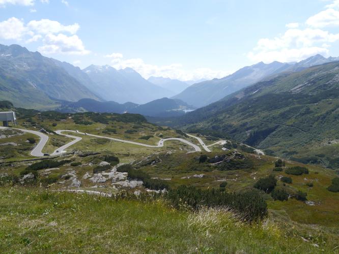
Roadway: The road is paved and in good condition for its entire length - a former principal trade route rebuilt in the early 1800s, so it's wide enough for two-way traffic with clear sightlines through most of the switchbacks. Like every high pass in this part of Graubunden, it closes under snow each winter and reopens seasonally, typically from May into November.
Traffic: Traffic is light. Since the San Bernardino road tunnel opened in 1967, nearly all through-traffic between the Mesolcina and Hinterrhein valleys uses the tunnel instead of the pass road, leaving the old route over the top mostly to cyclists, motorcyclists, and local traffic.
Parking: Soazza is a small village with informal roadside parking near the town center where the climb begins; there's no dedicated climbers' lot.
A standard road bike is fine - the pavement is good the entire way. Carry enough food and water for the full 14.9 miles and roughly 5,100 feet of gain, since services thin out well before the summit; Soazza itself has a shop and a couple of small restaurants, but plan on being self-sufficient above the village.
Pack a real jacket for the top - the pass sits close to 6,800 feet on a genuine weather divide between the Mesolcina and Hinterrhein valleys, and it's routinely colder and windier at the summit than down in Soazza.
Before heading out on any cycling adventure check out our Things to Bring on a Cycling Trip and use our interactive check list to ensure you don't forget anything.
Soazza and the wider Mesolcina Valley are quiet compared to better-known Swiss cycling valleys, so lodging is limited to a handful of small hotels and guesthouses - Bellinzona, about 30 minutes away by car, has a much fuller range of hotels and restaurants if you want more options.
The pass road is normally open from May into November and closes under snow the rest of the year. If you're basing in the Mesolcina Valley, our Routes in the Area tool is a good way to see what else is nearby - Alpe di Cadinello, one of the hardest paved climbs in Switzerland, starts about ten miles south in Roveredo.
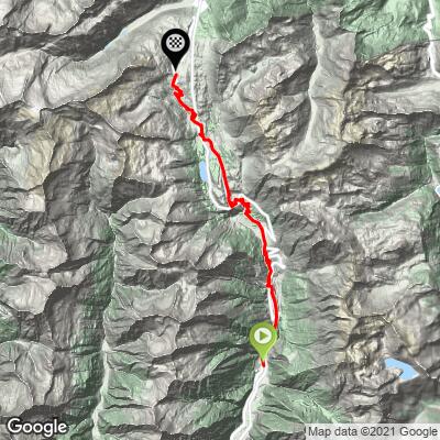
ROUTE MAP
MEMBER RATING
CURRENT WEATHER
PJAMM TRIPS ADVENTURE STARTER BUNDLES
Check out PJAMM Adventure's prepackaged (self-guided) cycling trips. They will help you plan, document and conquer your next adventure.
NEARBY CLIMBS (0) RADIAL PROXIMITY
FROM No Climbs Found
MEMBER REVIEWS & COMMENTS
Let us know what you thought of this climb. Signup for our FREE membership to write a review or post a comment.
Already have an account?
LOG IN HERE
NickPayne


The parallel motorway takes nearly all the traffic, so there is very little traffic when cycling the old road up the pass. The descent down the north side is hairpin heaven.
