
19
PDI
17.9 mi
DISTANCE
4,300 ft
GAINED
3.6 %
AVG. GRADE
FULL CLIMB STATS
INTRO
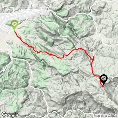
This route climbs from Lukavica, on the southern edge of Sarajevo in the city of Istočno Sarajevo (East Sarajevo), to the ski resort on Jahorina - the mountain that hosted the women's alpine skiing events of the 1984 Winter Olympics. It covers 28.8 km (17.9 mi) and gains 1311 m (4300 ft), finishing at about 1590 m (5216 ft) among the hotels and lifts of the resort village. Because the road drops 276 m (904 ft) in the middle, the 3.6% overall average badly undersells the climbing.
It's really two climbs. The first leaves the city through Kasindo and climbs the regional road past Tvrdimići, with a 5 km stretch averaging about 8.6% that lifts you out of the Sarajevo basin to a high point of roughly 1300 m (4265 ft) near Pavlovac, with views back over the city. After a fast descent to the Bistrica valley, the second climb follows the Jahorina road - a wide road built for ski traffic - for about 9.5 km at close to 5% through forest to the resort.
Jahorina is the best-known ski mountain in Bosnia and Herzegovina, but it doesn't shut down in summer: a gondola runs up toward Ogorjelica (1916 m / 6286 ft), there's a bar beside a small lake at the top, and a mountain coaster winds back down through the forest - which makes the resort a worthwhile finish rather than a dead end.
PLAN YOUR ROUTE
 We've partnered with Sherpa-Map.com to bring you the best route planning tool. With a PRO Membership you can use this climb as a reference when creating your route.
This route covers 28.8 km (17.9 mi) with 1311 m (4300 ft) of elevation gain and 276 m (904 ft) of descent, for a net average grade of 3.6%.
The first 2 km through Lukavica and Kasindo are nearly flat. The climbing starts at km 3, and after a brief flat at km 5 the hardest stretch of the day arrives: km 6 through km 10 average 8.6%, with km 8 at 9.6%.
After a nearly flat 2 km, the road climbs again to its first high point of about 1300 m (4265 ft) around km 15, then descends roughly 165 m (540 ft) to the Bistrica valley.
The final 9.5 km to Jahorina are steady and moderate, mostly 4-7%, with the steepest kilometer of the second climb (7.3%) just below the resort.
Steepest sections: 0.5 km at 12.5%, 1 km at 10.8%, 2 km at 9.2%, 5 km at 8.6%, 10 km at 6.5%.
Roadway: Paved throughout, on two regional roads: the road from Lukavica over the hills past Tvrdimići and Pavlovac, then the Jahorina road up from the Bistrica valley, which is wide and well maintained because it carries the resort's ski traffic. The upper road holds snow and ice through the long Jahorina winter, so the realistic road season is late spring to autumn.
Traffic: Busiest at the start, through Lukavica and Kasindo, which are built-up suburbs on the edge of the Sarajevo area. Above the city traffic thins out, and outside ski season the Jahorina road is quiet, serving mainly the resort.
Parking: Lukavica is an urban center, so park where permitted on its streets, or stay in Sarajevo and ride out - the start is only a few kilometers from Sarajevo International Airport and the city's southern neighborhoods. If someone is driving up to meet you, the resort village at the finish is the obvious rendezvous.
Gear: The 8-9% stretch early on is the crux of the ride, so a compact crankset with a 28- or 30-tooth cog is a sensible setup. The finish is about 1000 m (3300 ft) higher than the city, so pack a jacket for the long descent.
Provisions: Stock up in Lukavica before you start. Once you leave the suburbs, plan on being self-sufficient until Jahorina, where hotels and restaurants serve the resort - though not every bar stays open in summer and the shoulder seasons. Bosnia and Herzegovina still has areas contaminated by landmines from the 1990s war, so if you stop to explore, stay on the road and on marked trails.
Before heading out on any cycling adventure check out our Things to Bring on a Cycling Trip and use our interactive check list to ensure you don't forget anything.
Sarajevo is the natural base for this ride, a short spin from the start in Lukavica. For a different way home, descend from Jahorina toward Pale and pick up the Giro di Ćiro trail, opened in June 2026 along the corridor of the old narrow-gauge Ćiro railway: it runs through nine lit tunnels at a gentle 2.5-3.5% grade between the old Pale railway station and Sarajevo's City Hall (Vijećnica), following the Miljacka river along the foot of Mount Trebević.
Give yourself time at the top, too. In summer the Jahorina gondola runs toward Ogorjelica, with a zip line over the summit lake and a mountain coaster back down through the forest. Conditions on the mountain can be very different from the city, so check current conditions before you go with our Weather tool.
ROUTE MAP
MEMBER RATING
CURRENT WEATHER
PJAMM TRIPS ADVENTURE STARTER BUNDLES
Check out PJAMM Adventure's prepackaged (self-guided) cycling trips. They will help you plan, document and conquer your next adventure.
NEARBY CLIMBS (0) RADIAL PROXIMITY
FROM No Climbs Found
MEMBER REVIEWS & COMMENTS
Let us know what you thought of this climb. Signup for our FREE membership to write a review or post a comment.
Already have an account?
LOG IN HERE
