
31.8
PDI
10.3 mi
DISTANCE
4,403 ft
GAINED
8.1 %
AVG. GRADE
FULL CLIMB STATS
INTRO
PLAN YOUR ROUTE
 We've partnered with Sherpa-Map.com to bring you the best route planning tool. With a PRO Membership you can use this climb as a reference when creating your route.
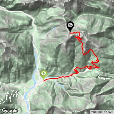
 Monte Paularo averages 7.5% over its 11.3 miles, but the two surfaces ride very differently. The lower paved miles through Treppo Carnico are gentle, before a genuinely steep pinch around Ligosullo - the opening quarter-mile of that stretch touches 14.3% and the first mile averages 11.6% - easing again toward Castel Valdajer. Once the road turns to gravel, the grade stays moderate but persistent, averaging around 9.7-10.0% over the closing miles into the Lago Dimon valley, with sustained pitches in the 13-14% range on the compact-stone surface.
Roadway: The first roughly two-thirds of the climb - through Treppo Carnico and the steep pitch at Ligosullo to Castel Valdajer - is fully paved and in good condition. Past the castle the road changes to a well-maintained compact-gravel forest road for the remaining several miles up the valley; the surface is solid rather than technical, but expect loose stone and some ruts, especially after rain.
Traffic: Traffic is light on the paved lower section and essentially nonexistent on the gravel upper section, which sees mostly hikers, cyclists, and the occasional farm or forestry vehicle.
Parking: Paluzza, at the base, is a small Carnic Alps town with informal roadside parking near the town center. Castel Valdajer, where the pavement ends, also has a parking area if you'd rather split the ride or only tackle the gravel section.
A standard road bike handles the paved lower two-thirds fine, but the final gravel miles are much more comfortable on a gravel or all-road bike with wider tires - at least 32mm is a real asset on the compact-stone surface, especially if it's wet.
Carry your own food and water for the full 11.3 miles; there's nothing at all past Paluzza and Ligosullo, and the road ends well short of any hut or refuge. If you want to reach the true 6,703-foot summit, bring shoes you can hike in - the final stretch beyond the rideable road is a steep trail, not a bike route.
Before heading out on any cycling adventure check out our Things to Bring on a Cycling Trip and use our interactive check list to ensure you don't forget anything.
Paluzza and the surrounding Carnia area are quiet compared to Friuli's better-known cycling destinations, with a handful of small hotels and agriturismi rather than big tourist infrastructure; Tolmezzo, about 20 minutes away, has a fuller range of services.
This is also legendary Giro d'Italia country - Monte Zoncolan and Passo della Forcella, two of Italy's hardest climbs, both start within about a dozen miles of here near Ovaro, and our Routes in the Area tool is a good way to see what else is nearby if you're building a multi-day Carnia trip.
ROUTE MAP
MEMBER RATING
CURRENT WEATHER
PJAMM TRIPS ADVENTURE STARTER BUNDLES
Check out PJAMM Adventure's prepackaged (self-guided) cycling trips. They will help you plan, document and conquer your next adventure.
NEARBY CLIMBS (0) RADIAL PROXIMITY
FROM No Climbs Found
MEMBER REVIEWS & COMMENTS
Let us know what you thought of this climb. Signup for our FREE membership to write a review or post a comment.
Already have an account?
LOG IN HERE
