
16.3
PDI
5.1 mi
DISTANCE
2,272 ft
GAINED
8.5 %
AVG. GRADE
FULL CLIMB STATS
INTRO
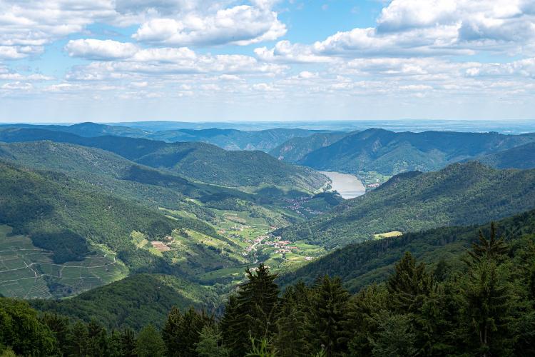
From the river, the Jauerling looks like a long, forested ridge sitting behind the wine terraces of Spitz. Riding up it, you find out it's the highest ground in the Wachau, and that the road to the top hardly ever lets up. It leaves the wine country above Spitz, climbs through Gut am Steg and into the forest, and holds the same hard pitch for 8 km.
We measure it at 8.1 km (5.1 mi) with 692 m (2272 ft) of climbing, an 8.5% average from 251 m to 943 m (824 to 3095 ft). No kilometer drops below 6.6% and none goes over 10.1%. There's nowhere to recover, but nothing that forces you out of the saddle either - find a rhythm in the first kilometer and hold it.
The top is a broad, grassy plateau at about 960 m with a 141 m red-and-white transmitter mast and a 38 m wooden lookout tower beside it. From the tower you can see down the Danube valley, over the Dunkelsteinerwald on the far bank and, on a clear day, all the way to the Alps. Just below the summit, the Naturpark-Gasthaus has a terrace that looks straight down the Spitzer Graben to the river - a good place to sit before the fast descent back to the vineyards.
PLAN YOUR ROUTE
 We've partnered with Sherpa-Map.com to bring you the best route planning tool. With a PRO Membership you can use this climb as a reference when creating your route.
Jauerling from Spitz gains 692 m (2272 ft) in 8.1 km (5.1 mi), from 251 m to 943 m (824 to 3095 ft), at an 8.5% average.
It's steady from bottom to top. The first two kilometers average 8.4% and 8.9%, kilometers 3 and 4 are the steepest at 10.1% and 9.9%, and the upper half holds between 6.6% and 8.9% all the way to the plateau.
The steepest kilometer averages 10.3% and the steepest 2 km 10%, but the steepest 100 m only reach 11.4% - there are no walls here, just a long, even grind with a handful of hairpins.
Roadway: Asphalt the whole way: the L7133 from the edge of Spitz through Gut am Steg to Oberndorf, then a short spur road to the summit car park. It's a narrow country road serving the farms and hamlets on the plateau and doesn't lead anywhere else, so the corners in the forest can collect leaves and grit after rain. At over 900 m the top holds snow and ice well after the vineyards below have thawed.
Traffic: Light. You'll mostly meet residents and, on fine weekends, visitors driving up to the lookout tower and the Naturpark-Gasthaus. The busy road is the one along the Danube through Spitz; once you turn uphill it goes quiet.
Parking: Park in Spitz and ride the 2 km out to the start - it's a gentle warm-up. If you're arriving by bike on the Danube Cycle Path, the climb is a short detour from the river, and the ferry from Spitz to Arnsdorf links it with the south bank. At the top there's parking right in front of the lookout tower if you're meeting a support car.
Gear: There's no single steep pitch to gear for, but 8 km at 8-10% adds up. A low gear around 34x30 lets you stay seated and keep the cadence up. The top is about 700 m above the Danube and often breezy, so bring a vest for the descent.
Provisions: Spitz is the place to fill bottles before you start. At the top, the buffet at the foot of the lookout tower is open daily from April until around All Saints' Day, 9:30 to 18:00, and on weekends in winter. The Naturpark-Gasthaus just below the top has the best terrace on the mountain but shorter hours: it closes a day or two midweek, drops to weekend lunches in late autumn and shuts for a few weeks before Christmas, so check naturpark-gasthaus.at before you plan lunch around it.
Before heading out on any cycling adventure check out our Things to Bring on a Cycling Trip and use our interactive check list to ensure you don't forget anything.
Spitz is one of the Wachau's best-known wine villages, and the valley around it - a UNESCO World Heritage landscape of terraced vineyards and apricot orchards - is worth a few days. End the ride at a Heuriger, one of the family wine taverns in Spitz and the villages along the river; if you're here in July, the Wachau apricots are in season.
For a short walk off the bike, the ruin of Hinterhaus castle sits on the ridge right above Spitz. The lookout tower at the top also houses a small herb and nostalgia museum with a herb garden outside.
The Jauerling has two more climbs on our site, from Aggsbach and from Groisbach, and all three finish on the same plateau, so linking two of them in one ride is easy.
ROUTE MAP

MEMBER RATING
CURRENT WEATHER
PJAMM TRIPS ADVENTURE STARTER BUNDLES
Check out PJAMM Adventure's prepackaged (self-guided) cycling trips. They will help you plan, document and conquer your next adventure.
NEARBY CLIMBS (0) RADIAL PROXIMITY
FROM No Climbs Found
MEMBER REVIEWS & COMMENTS
Let us know what you thought of this climb. Signup for our FREE membership to write a review or post a comment.
Already have an account?
LOG IN HERE
