

29.3
PDI
16.6 mi
DISTANCE
5,242 ft
GAINED
5.7 %
AVG. GRADE
FULL CLIMB STATS
INTRO
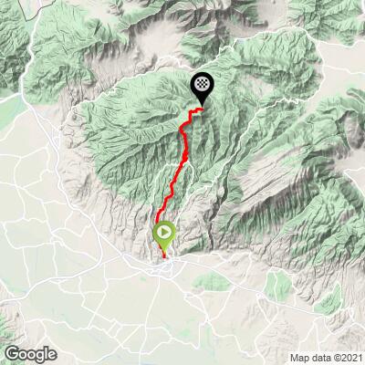
This long, remote climb runs 26.7 km (16.6 mi) from the hamlet of Chrysopigi, north of Serres in Greece's Central Macedonia region, up to the Lailias ski center on Mount Vrontous, gaining 1,598 m (5,242 ft) at a 5.7% average grade. The road finishes near 1,596 m (5,237 ft), just below the resort's high point and the Prophet Elias summit refuge at 1,849 m (6,066 ft) above it.
Almost the entire climb passes through the Lailias forest, a dense stand of beech and European red pine on the western slopes of Vrontous - deer, wild boar, and even a small population of brown bears live in its steeper northern reaches, though sightings from the road are rare. The road itself is a real workout: currently ranked #356 in the world on PJAMM's difficulty index, with roughly 7 hairpin turns and a steepest kilometer over 11%, and it's regularly listed among the toughest, longest climbs in Greece.
Lailias has operated as a ski area since 1978 and still runs Friday through Sunday and holidays each winter, from late November into March - the road gets plowed and kept open through the snow season rather than closed, though the climate at nearly 1,600 m (5,200 ft) still makes warmer months the realistic window for cycling.
PLAN YOUR ROUTE
 We've partnered with Sherpa-Map.com to bring you the best route planning tool. With a PRO Membership you can use this climb as a reference when creating your route.
 This climb averages a moderate-looking 5.7% over its full 26.7 km (16.6 mi), but that number smooths over a genuinely uneven profile. The steepest kilometer averages 11.9%, and shorter pinches bite harder still: the steepest 100 yards hits 17.5%, the steepest quarter mile 13.3%, and the steepest half mile 12.7%. Zoomed out, the steepest mile averages 10.7%, the steepest 2 km 11.1%, and the steepest 5 km 9.5% - so while there are flatter, recovery-friendly stretches through the forest, several sustained ramps well into double digits are mixed in throughout, not just clustered at the very top. Total elevation gain is 1,598 m (5,242 ft), with 77 m (254 ft) of net descent along the way, spread across roughly 7 hairpin turns.
Roadway: The road is paved the entire way from Chrysopigi to the Lailias ski center, serving as the main access route to a working winter resort, so it sees more consistent maintenance than a typical rural mountain road. During the ski season (late November to mid-March) it's cleared of snow daily to stay open for visitors, which is a reasonable proxy for decent year-round upkeep.
Traffic: Light to moderate. Outside of ski-season weekends, this is a quiet forest road with little traffic beyond locals and the occasional hiker or forestry vehicle. On winter Friday-Sunday ski days, expect more car traffic headed to the resort, though summer cycling season largely avoids that.
Parking: Chrysopigi is a hamlet of well under 100 residents with no formal parking infrastructure - a spot along the village's main road near where the climb begins works fine. Serres, about 20 km south, is the practical base for anything beyond a quick ride, with a full range of hotels, restaurants, and bike shops.
There are no services of any kind along this climb once you leave Chrysopigi - no shops, cafes, or water sources in the Lailias forest until you reach the ski center itself, which mainly operates in winter and may not have anything open in the summer cycling season. Carry all the water and food you'll need for the full 26.7 km (16.6 mi). The finish sits close to 1,600 m (5,200 ft), so pack a layer for the descent even on a warm day - temperatures in the beech forest and at altitude run noticeably cooler than down in Serres. A compact or wide-range gearing setup will help on the steeper hairpin sections.
Before heading out on any cycling adventure check out our Things to Bring on a Cycling Trip and use our interactive check list to ensure you don't forget anything.
Serres, about 20 km south of Chrysopigi, is the practical base for this climb - a real city with a full range of hotels, restaurants, and bike shops, and the nearest place to restock before or after the ride. Chrysopigi itself is little more than a crossroads hamlet, so don't expect services there beyond a place to park.
The Lailias forest at the top is a genuine destination in its own right outside of cycling - it's one of the most-visited natural areas in this part of Macedonia, known for its beech and pine woods and mountain scenery, and worth a slower look if you have the time once you've finished climbing. Our Routes in the Area tool can help you find other climbs to combine with this one if you're building a longer trip through northern Greece.
ROUTE MAP
MEMBER RATING
CURRENT WEATHER
PJAMM TRIPS ADVENTURE STARTER BUNDLES
Check out PJAMM Adventure's prepackaged (self-guided) cycling trips. They will help you plan, document and conquer your next adventure.
NEARBY CLIMBS (0) RADIAL PROXIMITY
FROM No Climbs Found
MEMBER REVIEWS & COMMENTS
Let us know what you thought of this climb. Signup for our FREE membership to write a review or post a comment.
Already have an account?
LOG IN HERE
