

17.1
PDI
21.9 mi
DISTANCE
4,058 ft
GAINED
3.4 %
AVG. GRADE
FULL CLIMB STATS
Page Contributor(s): Ard Oostra, Switzerland
INTRO
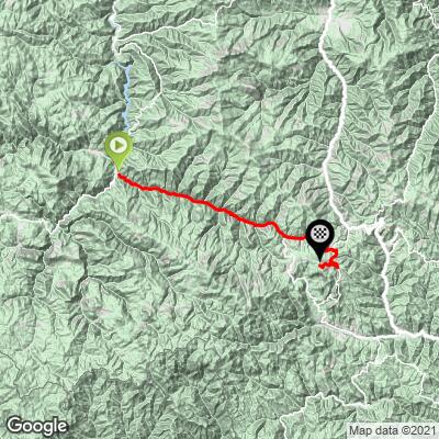
You'll spot the finish long before you reach it. The Snezhanka TV tower, 156 m (512 ft) of concrete on top of the ski runs above Pamporovo, is the landmark of the central Rhodopes, and this climb ends right underneath it after a 35.3 km (21.9 mi) ride up from Devin.
It's a long haul that's mostly gentle: 1237 m (4058 ft) of climbing at an average of 3.4%. For the first 18 km the road follows the river valley east at 1 to 4%, an easy spin through forest and past the stone-roofed houses of Shiroka Laka. Then it tilts up past Stoykite, rolls on toward Pamporovo at 3 to 5%, and leaves the real work for the end - the last 2 km to the tower average over 8%, and the steepest kilometer hits 10.3%.
Shiroka Laka is the place to slow down. The village is a protected architectural and folklore reserve, with Rhodope houses built in tiers up both banks of the river and a folk music school founded in 1972. At the top, the tower's upper ring holds a panoramic cafe looking out over the Rila and Pirin ranges and, on a very clear day, the Aegean.
PLAN YOUR ROUTE
 We've partnered with Sherpa-Map.com to bring you the best route planning tool. With a PRO Membership you can use this climb as a reference when creating your route.
Pamporovo climbs 35.3 km (21.9 mi) from 712 m (2337 ft) in Devin to 1921 m (6302 ft) below the Snezhanka tower, an average of 3.4% with 1237 m (4058 ft) of total climbing.
0 to 18 km: About 2.4%, never more than 4% in any kilometer - the long valley run through Beden and Shiroka Laka.
18 to 21 km: Around 6%, the first real climbing, up toward Stoykite.
21 to 27 km: Easier again, around 3%.
27 to 33 km: About 4%, steady climbing into Pamporovo.
33 to 35.3 km: The steep finish, over 8% on the road up to the tower, with one kilometer above 9%.
18 to 21 km: Around 6%, the first real climbing, up toward Stoykite.
21 to 27 km: Easier again, around 3%.
27 to 33 km: About 4%, steady climbing into Pamporovo.
33 to 35.3 km: The steep finish, over 8% on the road up to the tower, with one kilometer above 9%.
The steepest kilometer averages 10.3%, the steepest 0.5 km 11.1% and the steepest 2 km 8.7%.
Roadway: The valley road from Devin through Shiroka Laka is good two-lane asphalt with a center line. The last stretch is the access road from Pamporovo up to the tower, narrower and steeper as it winds up between the ski runs. In winter the top is under snow and the slopes belong to skiers.
Traffic: Moderate in the valley, where this is the main road between Devin and Shiroka Laka, but rarely heavy. Traffic builds around Pamporovo, one of Bulgaria's main ski resorts, which is at its busiest in the winter season and much quieter in summer.
Parking: Park in Devin near the start. For a shorter day, start from Shiroka Laka, about 16 km up the road, or drive to Pamporovo and ride just the steep finish to the tower.
Gear: A compact with a 28 or 30 covers it - most of the climb is gentle, and you only need the low gears for the last couple of kilometers. Bring a jacket: the top is close to 2000 m, it can be windy and cool even in summer, and the descent is long.
Provisions: Stock up in Devin. Shiroka Laka and Pamporovo both have places to eat and drink, and the cafe in the tower is a good reward at the top - there's a fee to go up the tower, which has a lift.
Before heading out on any cycling adventure check out our Things to Bring on a Cycling Trip and use our interactive check list to ensure you don't forget anything.
Shiroka Laka is the highlight on the way up - give yourself time to walk its streets and old stone bridges. If you can be here on the first Sunday of March, its Pesponedelnik kukeri festival, with masked dancers in huge costumes, is one of the best known in Bulgaria.
Pamporovo makes an easy base in summer, with plenty of hotels, and Smolyan, the regional town, is just down the road. Devin, at the start, is the other option.
The tower is open year-round and was finished in 1978; on a clear day the view from the top reaches across three mountain ranges. The weather on Snezhanka can change quickly, so look at the summit forecast in our Weather tool on the morning you ride.
ROUTE MAP
MEMBER RATING
CURRENT WEATHER
PJAMM TRIPS ADVENTURE STARTER BUNDLES
Check out PJAMM Adventure's prepackaged (self-guided) cycling trips. They will help you plan, document and conquer your next adventure.
NEARBY CLIMBS (0) RADIAL PROXIMITY
FROM No Climbs Found
MEMBER REVIEWS & COMMENTS
Let us know what you thought of this climb. Signup for our FREE membership to write a review or post a comment.
Already have an account?
LOG IN HERE
