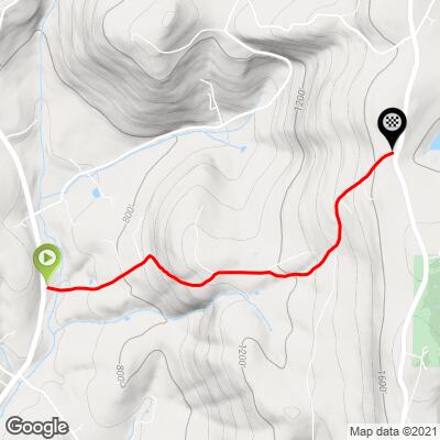
8.1
PDI
1.9 mi
DISTANCE
1,008 ft
GAINED
10.1 %
AVG. GRADE
FULL CLIMB STATS
Page Contributor(s): Dan Razum, Campbell, CA, USA; Aryeh Nirenberg, Baltimore, Maryland; Chuck Haskins;
INTRO
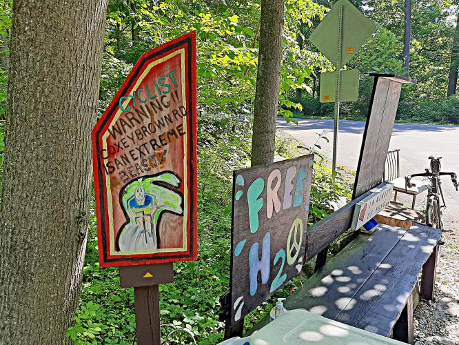
This 1.9 mile bike climb is located in MD, USA. The average gradient is 10.1% and there is a total elevation gain of 1,008 ft, finishing at 1,752 ft.
Use the profile tool, route map, and weather forecast to conquer this cycling climb.
Use the profile tool, route map, and weather forecast to conquer this cycling climb.
PLAN YOUR ROUTE
See more details and tools regarding this climb's grade via our interactive Profile Tool.
Information Not Available
If you have any information regarding this climb, we'd like to hear from you. Click the CONTRIBUTE button to share your thoughts with us.
Information Not Available
If you have any information regarding this climb, we'd like to hear from you. Click the CONTRIBUTE button to share your thoughts with us.
Before heading out on any cycling adventure check out our Things to Bring on a Cycling Trip and use our interactive check list to ensure you don't forget anything.
Parking is available near the top of the climb on Gambrill Park Rd. about 1/2 mile north of Coxey.
ROUTE MAP
MEMBER RATING
CURRENT WEATHER
PJAMM TRIPS ADVENTURE STARTER BUNDLES
Check out PJAMM Adventure's prepackaged (self-guided) cycling trips. They will help you plan, document and conquer your next adventure.
NEARBY CLIMBS (0) RADIAL PROXIMITY
FROM No Climbs Found
MEMBER REVIEWS & COMMENTS
Let us know what you thought of this climb. Signup for our FREE membership to write a review or post a comment.
Already have an account?
LOG IN HERE
dyben


I tackled coxey brown at the end of 5 hard consecutive days on the bike. It felt wicked hard as I was beat up but I would say is super tough either way. Gambrill state park is absolutely gorgeous making the trip to hit coxey totally worth!!
hrefhronald
Tough climb (probably the toughest in Maryland) but the best part isn't the climb itself. It's that Coxed Brown Road is located in Gambrill State Park with dozens of other amazing and challenging climbs within a mile. If you want some vertical, head out to Gambrill and make sure to hit the king of the park: Coxey Brown Road.
haskinsc

I park at the top in the gravel lot on Gambrill Park Rd about a quarter mile north of Coxey then descend Coxey to Harmony Rd, turn around and climb back up. It's pretty tough on one wheel.