
25
PDI
11.1 mi
DISTANCE
3,949 ft
GAINED
6.6 %
AVG. GRADE
FULL CLIMB STATS
Page Contributor(s): Ties Arts, Bussum, Netherlands
INTRO
PLAN YOUR ROUTE
 We've partnered with Sherpa-Map.com to bring you the best route planning tool. With a PRO Membership you can use this climb as a reference when creating your route.
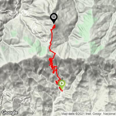
 The average understates how the climb actually rides. The first 11 km to the Alto de Velefique pass are steep and sustained, averaging well over 7% through a long series of hairpins with no real flat ground. After the pass, the road descends briefly before the final spur to Tetica de Bacares, which is short but punishing - the last few hundred meters of pavement near the summit antennas pitch up sharply, with reported grades approaching 20% over a rougher, patched surface.
Roadway: Paved from Velefique to within a few hundred meters of the Tetica de Bacares summit. The lower climb to the Alto de Velefique pass is in the same well-traveled condition as the Alto Velefique page describes. The final spur past the pass narrows considerably, and the last stretch near the summit antennas is reported as rougher, patched pavement rather than fresh asphalt - expect a change in surface quality right when the road is at its steepest.
Traffic: Light. This is a quiet mountain road serving a small village and a handful of mountaintop installations, not a through route, so traffic is minimal outside of Vuelta a España training season, when it's a popular climb for visiting cyclists.
Parking: Velefique's village center has roadside parking and is the natural place to start. There's no services or formal parking at the top near the antennas - riders typically just pull off where the road ends.
Velefique is a small village, so don't expect much beyond the basics - a village bar or two for coffee, but no bike shop or large supermarket. Top off water and food before you leave, since there's nothing at all along the climb once you're out of town, all the way to the antennas at the top.
Gearing matters here: the lower climb to the pass is a sustained 7%+ effort with little recovery, and the final ramp to Tetica de Bacares' summit is reported to pitch up near 20% on rough pavement - a compact or triple crankset with an easy low gear is worth having for that last push.
Before heading out on any cycling adventure check out our Things to Bring on a Cycling Trip and use our interactive check list to ensure you don't forget anything.
Velefique is a classic Sierra de los Filabres mountain village - tightly packed whitewashed houses with distinctive dark slate roofs and eaves, set at 920 m on narrow, steep streets. It's a quiet base with limited services, so most visiting cyclists stay in Almeria city or a larger town nearby and drive in for the climb.
Tetica de Bacares gets its name from its rounded silhouette when viewed from the valley below, and it's more than a scenic summit: in 1879 it served as one of the sighting points in the first geodetic triangulation connecting the Spanish and North African coastlines, alongside Mulhacen and peaks on the other side of the Mediterranean.
While you're in the area, Calar Alto - home to the largest astronomical observatory in continental Europe and a repeat Vuelta a España summit finish - climbs a parallel valley to the west and is well worth combining with this one over a multi-day trip; see our Routes in the Area tool.
ROUTE MAP
MEMBER RATING
CURRENT WEATHER
PJAMM TRIPS ADVENTURE STARTER BUNDLES
Check out PJAMM Adventure's prepackaged (self-guided) cycling trips. They will help you plan, document and conquer your next adventure.
NEARBY CLIMBS (0) RADIAL PROXIMITY
FROM No Climbs Found
MEMBER REVIEWS & COMMENTS
Let us know what you thought of this climb. Signup for our FREE membership to write a review or post a comment.
Already have an account?
LOG IN HERE
