![]()
Cycling the White Rim Trail - Moab and Canyonlands National Park
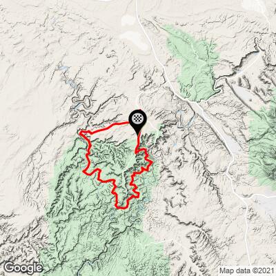
Ride 103 miles gaining 6,560’
![]()
Route conditions:
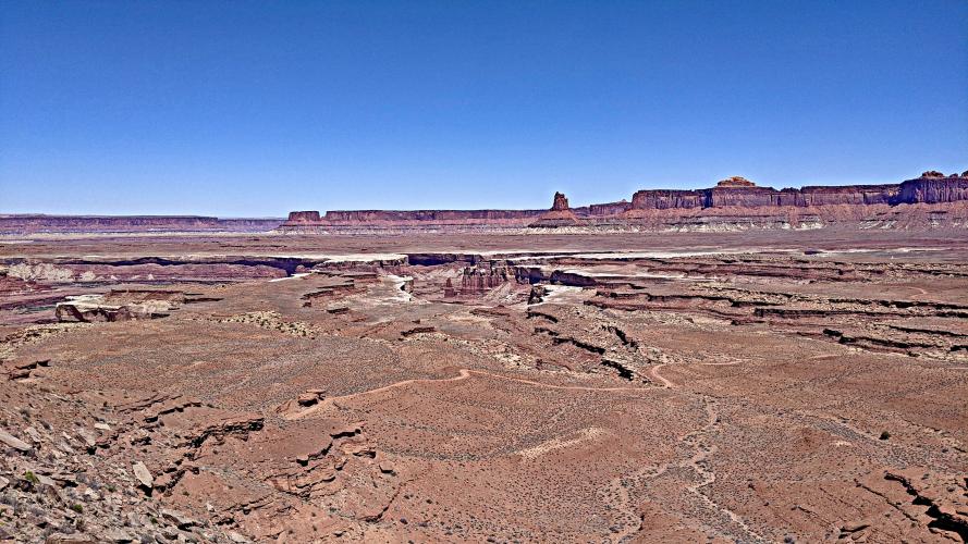
The entirety of the trail is double track/jeep road. For 80 percent of the ride, you will be treated to gentle, sub 3 percent inclines/declines or largely flat sections with stunning scenery. One can rubberneck to their heart's content and soak in the majesty of this place. However a few caveats mandate further warning and detail. You will roll across slick rock for less than 5 percent of the ride.
![]()
There is episodic sand, but I only required a dismount once at a section immediately adjacent to the Green river on the west side of the loop. There are 2 descents that merit one's attention. The first can be found at the onset of the route.
![]()
Shafer trail has some loose rock and is a series of switchbacks with significant exposure. Falling is not allowed. Ridden in a clockwise fashion and starting at the intersection of Island in the Sky Road aka Hwy 313 and Shafer Trail, one will presumably have quite a heavy pack. The pack adds to the precarious nature of the descent. One must have some mountain bike handling skills for both the Shafer descent and the second decline.
![]()
The 2nd decline can be found at the 46 mile mark. Again, there is some exposure that would be fatal if you fell. This section is brief in comparison to the Shafer decline, maybe only 400m in total. One could easily walk the 2nd decline. With regards to climbs, there is a 15+ percent incline at approximately the 55 mile mark. Loose footing will prompt one to walk the estimated 400 m. At the 70 miles mark, there is another stinger in the form of several switchbacks. Again, walking is a likely outcome unless there had been recent rain to aid in traction. Finally, at the 81 mile mark, one will be treated to the climb out of the river on Mineral Basin Road. An approximate 9-10 percent grade over 1-2 miles will challenge your legs. Once out of the canyon, there is an additional 9 miles of 3-5 incline to rejoin Hwy 313. From 313, 6 miles of pavement with an adequate shoulder stand between you and your vehicle. Perhaps another 100m of climbing remain.
![]()
Supplies:
I completed the ride in mid May. Weather was cooperative and it was never above 80 degrees.
Regardless, it seems difficult to carry enough water. I consumed approx 12 L of water over the course of the trip. You will in all likelihood encounter tour groups completing the loops as a multi day affair supported by vehicles. Ask for water and food whenever you can. Everyone I queried was kind and supportive once they realized I was attempting the ride in one day. 2 tubes and a patch kit are mandatory. There is no cell service save for the section of Mineral Basin Road, where it is patchy at best. I rode on an XC full suspension Mountain bike. It can be done with a hardtail, but I would not recommend it. Comfort is important as one will be spending many hours in the saddle.
![]()
Timing:
I suggest starting at first light. The ride is best done in October or May. Budget 3 or 4 days in Moab when attempting this ride. The wind can be brutal in this area. A 20 mile per hour western wind would crush the spirit on this outing. Cherry pick for conditions, if you will.
Alternative routes:
If one wished to avoid the last 15 miles (again assuming we start at the intersection of 313 and Shafer Trail), it would be easy to leave a car at the top of the canyon on Mineral Bottom road. Doing so would save one from the 3 percent uphill that seems to roll forever after you have completed 80 plus miles already.