

17.7
PDI
14.9 mi
DISTANCE
3,798 ft
GAINED
4.1 %
AVG. GRADE
FULL CLIMB STATS
Page Contributor(s): Ard Oostra, Switzerland
INTRO
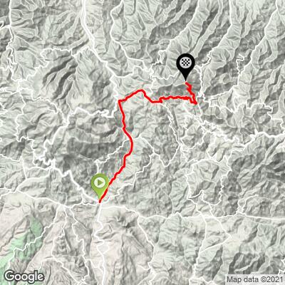
Adelphi (Adelfoi) is the 1612 m (5289 ft) peak at the eastern end of the Troodos range, and this long climb reaches it from Saittas, just below Moniatis on the Limassol side of the mountains. Our route covers 23.9 km (14.9 mi) with 1158 m (3798 ft) of climbing, rising from 604 m (1982 ft) to 1575 m (5168 ft) just below the summit, for a net 4.1% average. By our rankings it's the second-hardest climb in Cyprus, behind only Mount Olympus, and #1266 in the world.
It's a climb in three acts. The first 11 km (6.8 mi) follow the E801 north past Pelendri and Amiantos at a steady 4-7%, through pine forest and terraced hillsides. The middle third is a rolling traverse along the E909 through Kyperounta and on to Chandria, often called the second-highest village in Cyprus - roughly 8 km (5.0 mi) of ups and downs between about 1180 and 1250 m (3871-4101 ft). Then the real work: from Chandria the road climbs the flank of Adelfoi for the final 4.9 km (3.0 mi) at about 7.5%, with the last kilometer close to 9%.
The reward is one of the finest viewpoints in the Troodos. On a clear day the Adelfoi ridge looks across much of the island, from Mount Olympus in the west to both coasts and, on the clearest days, the Kyrenia range in the north, and the Madari ridge trail links the summit area with the Madari fire lookout tower, which you can climb. At this altitude conditions can be very different from the coast, so check current conditions with our Weather tool before you head up.
PLAN YOUR ROUTE
 We've partnered with Sherpa-Map.com to bring you the best route planning tool. With a PRO Membership you can use this climb as a reference when creating your route.
Our route covers 23.9 km (14.9 mi) with 1158 m (3798 ft) of climbing and 187 m (613 ft) of descent along the way, for a net 4.1% average from 604 m (1982 ft) to 1575 m (5168 ft). The steepest kilometer averages 10.1%, the steepest 2 km 9.1%, the steepest 5 km 7.8% and the steepest 10 km 5.5%.
The first 11 km (6.8 mi) to the E909 junction near Kyperounta climb steadily, mostly at 4-7%, to about 1198 m (3930 ft). The next 8 km (5.0 mi) through Kyperounta to Chandria are rolling, with a rise to about 1254 m (4114 ft) and a descent of roughly 70 m (230 ft) before the final ascent. From around km 19 the road climbs 367 m (1204 ft) in 4.9 km (3.0 mi), about 7.5%, steepening to close to 9% over the last kilometer.
Roadway: Paved the whole way. The E801 and E909 are decent mountain roads, narrow in places, with Cyprus's 65 km/h (40 mph) rural speed limit. Beyond Chandria the E931 is narrow with no lane markings, and the final climb onto Adelfoi is a single-lane road whose last kilometer is rough and broken, so take the descent slowly. The dirt forest roads that continue toward the summit ridge are for forestry vehicles only. The Troodos can see snow and short road closures in winter and early spring - check the Cyprus Department of Public Works road updates before riding in the cold months.
Traffic: Light. The E801 carries some local traffic to the Pitsilia villages, and the E909 is Kyperounta's main street, but the roads beyond Chandria are very quiet. Local drivers on these narrow mountain roads often go slowly, so expect to sit behind a farm pickup now and then on the descent.
Parking: Saittas is a small roadside village on the busy B8 Limassol-Troodos road, so park considerately well off the carriageway. Trimiklini, a few kilometers down the B8 and covered on our Mount Olympus (Trimiklini) page, is an alternative staging point. There's no proper parking at the finish, so Kyperounta or Chandria, before the final climb, are the better places for a support car to meet you.
Gear: Nothing here is brutally steep, so a compact crankset with a 28- to 32-tooth cog is plenty. The bigger factor is altitude: you finish almost 1000 m (3281 ft) above the start, so carry arm warmers and a wind layer for the long descent.
Provisions: Fill your bottles before you leave the B8. Kyperounta, between roughly km 12 and km 16, is the largest village on the route and your best chance to refuel, and Chandria is the last village before the final climb. There's nothing at the top.
Before heading out on any cycling adventure check out our Things to Bring on a Cycling Trip and use our interactive check list to ensure you don't forget anything.
Our Mount Olympus (Trimiklini) page covers the Troodos resort area, Platres and the painted churches of the western valleys, so this page is about Pitsilia, the eastern end of the range. Kyperounta is home to the Kyperounda Winery, founded by local grape growers in the late 1990s and, at around 1400 m (4593 ft), billed as one of the highest wineries in Europe. Lower on the climb, a short detour east of the E801 leads to Pelendri, whose Church of the Holy Cross (Timios Stavros) is one of the UNESCO-listed painted churches of the Troodos.
For a walk at the top, the Madari ridge nature trail runs 3.8 km (2.4 mi), about two hours, from Doxa soi o Theos - on the Kyperounta-Spilia road about 2 km (1.2 mi) from Kyperounta, with a drinking fountain at the trailhead - along the ridge past the Madari fire lookout tower to the top of Adelfoi, with panoramic views at 1400-1600 m (4593-5249 ft) and endemic plants such as golden oak and Cyprus skullcap along the way.
ROUTE MAP
MEMBER RATING
CURRENT WEATHER
PJAMM TRIPS ADVENTURE STARTER BUNDLES
Check out PJAMM Adventure's prepackaged (self-guided) cycling trips. They will help you plan, document and conquer your next adventure.
NEARBY CLIMBS (0) RADIAL PROXIMITY
FROM No Climbs Found
MEMBER REVIEWS & COMMENTS
Let us know what you thought of this climb. Signup for our FREE membership to write a review or post a comment.
Already have an account?
LOG IN HERE
