
28.8
PDI
13.3 mi
DISTANCE
4,646 ft
GAINED
6.6 %
AVG. GRADE
FULL CLIMB STATS
INTRO
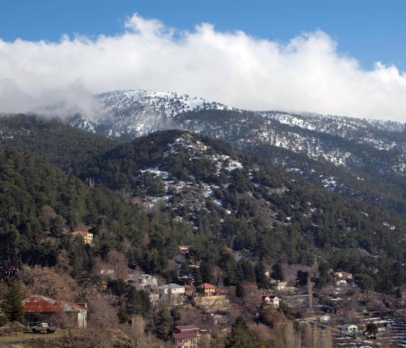
Mount Olympus in Cyprus - locally known as Chionistra - is the highest point on the island at roughly 1,952 m (6,404 ft), and this route climbs to it from the village of Trimiklini on the Limassol side of the Troodos Mountains. Over 21.4 km (13.3 mi) the road gains 1,416 m (4,646 ft) at a 6.6% average grade, starting among the vineyards and fruit orchards around Trimiklini at 553 m (1,813 ft) and finishing high in the pine forests near the Troodos ski area.
The climb is steady rather than brutal - the steepest kilometer averages around 15.1% - and the reward is the Troodos range itself: dense Aleppo and black pine forest, wide views back down toward Limassol and the coast, and a noticeably cooler climate than the lowlands below. Road surface and traffic are both good for most of the route, since this is the main paved link between Limassol and the mountain resorts. The true summit is capped by British and Cypriot military radar installations, so the road tops out at a checkpoint just below the peak rather than reaching the antenna itself.
Because Mount Olympus is Cyprus's highest terrain, conditions at the top can differ sharply from those at the base - the Troodos road network saw several brief winter and even a rare spring snow closure in 2026, so check current conditions with our Weather tool before heading up in the cooler months.
PLAN YOUR ROUTE
 We've partnered with Sherpa-Map.com to bring you the best route planning tool. With a PRO Membership you can use this climb as a reference when creating your route.
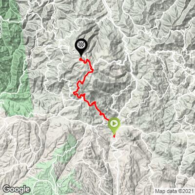
 From Trimiklini (553 m / 1,813 ft), the climb to Mount Olympus covers 21.4 km (13.3 mi) and gains 1,416 m (4,646 ft) at a 6.6% average grade, topping out at 1,957 m (6,423 ft) near the summit. The grade is remarkably consistent for a climb this long - there's no flat or downhill relief to speak of - but it's not uniformly steep either. The steepest kilometer comes in around 15.1%, and the steepest full mile averages 11.9%, both typically found on the switchbacked sections higher on the mountain as the road works its way up through the pine forest toward Troodos.
Roadway: The B8 is paved the entire way from Trimiklini to the Troodos summit area and is the principal route linking Limassol to the Troodos resorts, so it is kept in good condition and well signed. The Troodos Mountains saw several short-lived snow closures in 2026, including a rare May snowfall that briefly closed the Platres-Troodos and Kakopetria-Troodos roads - check Cyprus Department of Public Works road-status updates before riding in winter or early spring.
Traffic: Traffic is light through Trimiklini and the lower vineyard slopes, picking up somewhat on weekends and during ski season (December-March) as the road approaches the Troodos resort area, where day-trippers and ski traffic share the route. Outside those peak periods, the upper mountain sections are quiet.
Parking: Trimiklini's village center, alongside the roadside market on the B8, has informal roadside parking and is a natural staging point at the base of the climb. Riders continuing toward the Troodos summit can also find parking near the Troodos Square resort area at the top.
Gear: A compact or triple crankset is worth having - the average grade is manageable at 6.6%, but the steepest kilometer touches roughly 15.1%, and at nearly 1,957 m (6,423 ft) the finish is noticeably cooler than the start, so pack a light jacket or arm warmers for the descent.
Provisions: Trimiklini's roadside market sells fruit, wine, and snacks and is a good place to stock up before starting. There are cafes and tavernas in the Troodos resort area near the top, but nothing reliable in between, so carry enough water for the full 21.4 km (13.3 mi).
Before heading out on any cycling adventure check out our Things to Bring on a Cycling Trip and use our interactive check list to ensure you don't forget anything.
Trimiklini is about 30 minutes' drive from Limassol and its coastal hotels, making the climb an easy day trip if you're based on the south coast. The village itself has limited lodging, but Platres and the Troodos resort area near the summit have small hotels and guesthouses if you'd rather stay up in the mountains.
Summer (June-September) is warm at the base but comfortably cool at altitude, making it the most reliable season for riding; spring and autumn are pleasant too. Winter brings a real chance of snow and short road closures near the top, so plan accordingly if riding between December and March. The Troodos Mountains are also home to several UNESCO-listed painted churches in villages like Pedoulas and Kakopetria, worth combining with a visit if you have extra time in the area.
ROUTE MAP
MEMBER RATING
CURRENT WEATHER
PJAMM TRIPS ADVENTURE STARTER BUNDLES
Check out PJAMM Adventure's prepackaged (self-guided) cycling trips. They will help you plan, document and conquer your next adventure.
NEARBY CLIMBS (0) RADIAL PROXIMITY
FROM No Climbs Found
MEMBER REVIEWS & COMMENTS
Let us know what you thought of this climb. Signup for our FREE membership to write a review or post a comment.
Already have an account?
LOG IN HERE
