
21
PDI
5.5 mi
DISTANCE
2,709 ft
GAINED
9.2 %
AVG. GRADE
FULL CLIMB STATS
INTRO
Col de Romme from Cluses climbs 8.8 km (5.5 mi) and 826 m (2,709 ft) at an average grade of 9.2%, from the Arve valley at 489 m (1,604 ft) to the hamlet of Romme at 1,293 m (4,241 ft), just below the pass at about 1,297 m (4,255 ft). It ranks #888 on our list of the world's hardest climbs.
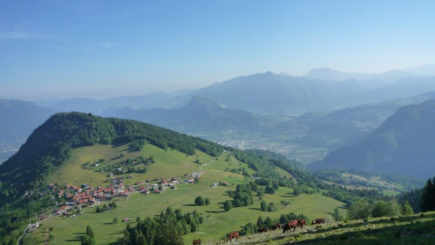
The start is the hard part. The road leaves Cluses straight into a wall near 12%, with the first 2 km (1.2 mi) cut along a cliff face, before the grade settles near 10% and then eases through Nancy-sur-Cluses, about 4 km (2.5 mi) up. Past the village it steepens again through forest into open pasture with cattle and views over the Arve valley, finishing at Romme, a small hamlet of wooden chalets.
The Tour de France has crossed the Col de Romme three times: in 2009 (Stage 17, Fränk Schleck first over the top), 2018 (Stage 10, Julian Alaphilippe) and 2021 (Stage 8). It also featured in the 1992 Critérium du Dauphiné.
Tour de France 2021: Stage 8 (category 1) - Michael Woods (CAN) first to the top in the 2021 TdF
PLAN YOUR ROUTE
 We've partnered with Sherpa-Map.com to bring you the best route planning tool. With a PRO Membership you can use this climb as a reference when creating your route.
 Col de Romme averages 9.2% over 8.8 km (5.5 mi). The steepest 0.5 km (0.3 mi) averages 12.7%, the steepest 1 km (0.6 mi) 12.3%, the steepest 2 km (1.2 mi) 10.6% and the steepest 5 km (3.1 mi) 9.4%.
The steep part comes first: the opening kilometers out of Cluses run at 10-12% along a cliff face, with little warm-up. Around Nancy-sur-Cluses, about 4 km (2.5 mi) up, a few gentler sections give a chance to recover, but the road steepens again through the forest above the village before easing across open pasture to the finish. Pace the first 2 km (1.2 mi) conservatively, because there is very little flat road to recover on afterward.
Roadway: The road is paved all the way. The first 2 km (1.2 mi) hug a cliff face and are partly shaded, which helps on a hot day, and the road continues a short way past the hamlet of Romme, to about 1,320 m (4,331 ft).
Traffic: Mainly local. The road serves Nancy-sur-Cluses, the hamlet of Romme and its small ski area, and riders use it as a warm-up for the neighboring Col de la Colombière, so you will usually share it with other cyclists.
Parking: The local tourism office's Romme-Reposoir loop starts from the Parking du Musée de l'Horlogerie et du Décolletage in Cluses, which makes a convenient base for the climb. Cluses is also served by TER trains and the Léman Express, and sits beside the A40 motorway.
Provisions: Fill your bottles in Cluses before you start. There is a small fountain in the hamlet of Romme where you can top them up at the finish, and the tourism office's loop route lists bars and picnic areas around the Reposoir valley.
Gear: Use your lowest gears from the first pedal stroke: the opening 2 km (1.2 mi) run at 11-12% and the grade rarely drops below 7% afterward. The finish is at about 1,293 m (4,241 ft), so a light layer is useful for the descent.
Before heading out on any cycling adventure check out our Things to Bring on a Cycling Trip and use our interactive check list to ensure you don't forget anything.
Cluses (489 m / 1,604 ft) is an Arve valley town of about 17,000 people, halfway between Geneva and Chamonix and known as the capital of precision machining, an industry that grew out of watchmaking introduced here in 1720. The Musée de l'Horlogerie et du Décolletage tells that story and makes a good rest-day stop.
Romme feels a world away: a quiet hamlet of wooden chalets with a fountain, and a highlight of a 28.4 km (17.6 mi) loop through Le Reposoir, the Col de Romme and Nancy-sur-Cluses. Le Reposoir has a Carmelite monastery that is worth the detour.
The Col de la Colombière starts from Le Reposoir on the far side of the loop (see our Col de la Colombière page), and our Col de Pierre Carée (Magland) and Col de Joux Plane (Samoëns) pages cover other nearby climbs, so you can see other climbs nearby, or build a custom route from here, with our Routes in the Area tool.
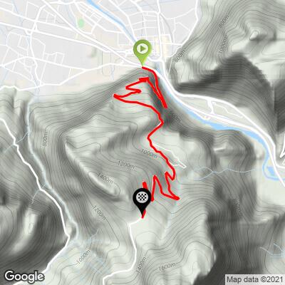
ROUTE MAP
MEMBER RATING
CURRENT WEATHER
PJAMM TRIPS ADVENTURE STARTER BUNDLES
Check out PJAMM Adventure's prepackaged (self-guided) cycling trips. They will help you plan, document and conquer your next adventure.
NEARBY CLIMBS (0) RADIAL PROXIMITY
FROM No Climbs Found
MEMBER REVIEWS & COMMENTS
Let us know what you thought of this climb. Signup for our FREE membership to write a review or post a comment.
Already have an account?
LOG IN HERE
