
18.3
PDI
8.6 mi
DISTANCE
2,946 ft
GAINED
6.5 %
AVG. GRADE
FULL CLIMB STATS
INTRO
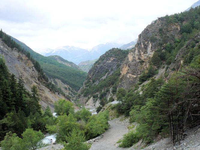
The Montée de Ceillac climbs 13.8 km (8.6 mi) from Maison du Roy, at the entrance to the Combe du Queyras, to the end of the D60 at the Fond de Chaurionde car park at 1962 m (6437 ft). It gains 898 m (2946 ft) at a 6.5% average, passing through the village of Ceillac, 1640 m (5381 ft), in the Queyras Regional Natural Park.
It is really three climbs in one. The first 6 km (3.7 mi) is the hard part, a steady 8 to 9% up the narrow, twisting valley below Ceillac, with the steepest kilometer at 10.6%. Then the walls open onto the wide, flat basin of Ceillac, and you get about 4 km (2.5 mi) of easy riding past the village and its meadows. The last 3.8 km (2.4 mi) kicks back up to around 8% as the road climbs the Mélezet valley to the car park where the pavement ends.
This is a dead-end road, which is a big part of its appeal. There is no through traffic, the scenery gets wilder the higher you go, and the finish sits at the foot of the hiking trails to Lac Sainte-Anne and Lac Miroir, two of the best-known lakes in the Queyras.
PLAN YOUR ROUTE
 We've partnered with Sherpa-Map.com to bring you the best route planning tool. With a PRO Membership you can use this climb as a reference when creating your route.
The Montée de Ceillac averages 6.5% over 13.8 km (8.6 mi), gaining 898 m (2946 ft) from 1066 m (3499 ft) at Maison du Roy to 1962 m (6437 ft) at the Fond de Chaurionde car park.
The steepest 91 m (100 yd) reaches 13.5%, the steepest 0.5 km (0.3 mi) 11.4% and the steepest kilometer (0.6 mi) 10.6%. The steepest 2 km (1.2 mi) averages 9.6% and the steepest 5 km (3.1 mi) 8.8%, all of it in the opening gorge section.
The first 6 km (3.7 mi) climbs 512 m (1680 ft) at about 8.5%. From there to the far end of the Ceillac basin, roughly 4 km (2.5 mi), the road barely rises at 2 to 3%, a real chance to recover. The final 3.8 km (2.4 mi) up the Mélezet valley averages about 7.7%, so save something for the finish.
Roadway: The D60 is paved the entire way, from Maison du Roy to the car park at the end of the road, and the road up to Ceillac is wide and well surfaced. It is open to traffic all year but can close for short periods in bad winter weather. If you ride in from Guillestre, the D902 approach to Maison du Roy is a corniche road cut into the rock above the Guil, prone to rockfall (it closed for several days in August 2026), so check the Hautes-Alpes department's road-status information before you go.
Traffic: Light. The D60 is the only road to Ceillac and a dead end, so you will only meet local traffic, visitors to the village and, in summer, hikers driving up to the trailheads. Expect a few more cars on the upper valley road on summer mornings.
Parking: If you are riding from Guillestre, our Col de Vars (Guillestre) page covers parking in town. To ride just the upper half, the Pied du Mélezet car park (start of the Lac Miroir trail) and the Fond de Chaurionde car park at the top (start of the quickest trail to Lac Sainte-Anne) are both in the Mélezet valley above Ceillac. Chaurionde fills quickly on summer days, so arrive early if you plan to park there.
Gear: A compact crankset is a good idea for the first 6 km (3.7 mi), where the grade holds at 8 to 9% and the steepest kilometer averages 10.6%. The finish is close to 2000 m (6562 ft) at the head of a high valley, so pack a jacket for the descent even in summer.
Provisions: Fill your bottles before you leave the D902. Ceillac, about 8.5 km (5.3 mi) into the climb, is the only village on the route, and the road above it climbs into open hiking country with nothing but trailhead car parks at the top.
Before heading out on any cycling adventure check out our Things to Bring on a Cycling Trip and use our interactive check list to ensure you don't forget anything.
Ceillac is a small Queyras village of fewer than 300 residents set in a broad, high basin, and it rewards a slow roll through the center. The late 15th-century Église Saint-Sébastien has an octagonal pink-marble fountain dated 1790 and an 18th-century sundial, while the older Église Sainte-Cécile stands alone in the fields near the hamlet of La Clapière, inside its old cemetery wall.
The end of the road is a trailhead for some of the best walking in the Queyras. From Fond de Chaurionde a path climbs to Lac Sainte-Anne at 2415 m (7923 ft) and its chapel, the site of a procession every 26 July, when parishioners from Maurin cross the Col Girardin from the Ubaye side. Lac Miroir at 2214 m (7264 ft) starts from the Pied du Mélezet, and the Cascade de la Pisse, which drops about 280 m (919 ft), is southeast of the village. Above it all is the Font Sancte, the highest summit in the Queyras at 3385 m (11,106 ft).
Down at Maison du Roy, the hydroelectric dam on the Guil dates from 1982. For Guillestre itself, Risoul, the Col de Vars and the Izoard, see other climbs nearby, or build a custom route from here, with our Routes in the Area tool.
ROUTE MAP

MEMBER RATING
CURRENT WEATHER
PJAMM TRIPS ADVENTURE STARTER BUNDLES
Check out PJAMM Adventure's prepackaged (self-guided) cycling trips. They will help you plan, document and conquer your next adventure.
NEARBY CLIMBS (0) RADIAL PROXIMITY
FROM No Climbs Found
MEMBER REVIEWS & COMMENTS
Let us know what you thought of this climb. Signup for our FREE membership to write a review or post a comment.
Already have an account?
LOG IN HERE
