
24.5
PDI
9.9 mi
DISTANCE
3,756 ft
GAINED
7.2 %
AVG. GRADE
FULL CLIMB STATS
INTRO
PLAN YOUR ROUTE
 We've partnered with Sherpa-Map.com to bring you the best route planning tool. With a PRO Membership you can use this climb as a reference when creating your route.
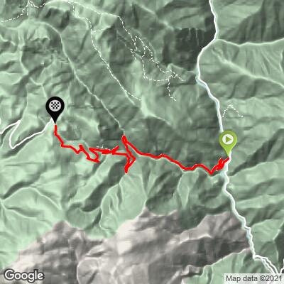
 From Saint-Sauveur-sur-Tinée to the pass, the route covers 15.9 km (9.9 mi) and climbs 1,145 m (3,756 ft) at an average grade of 7.2%.
The lower gorge section is fairly consistent, holding in the 8% range for the first several kilometers before easing briefly near Roubion. Above the village, the road turns punchy - the steepest kilometer averages 10.9%, and the steepest 100 yards spikes to nearly 18.8%, one of the sharper ramps you'll find on a categorized Alpes-Maritimes climb. There's no sustained flat section anywhere on the route to recover.
Roadway: The pavement is well maintained for most of the climb, though heavy summer storms can wash gravel and debris onto the road, especially on the more exposed sections above Roubion - a bit of extra caution is worth it after rain. Like most high Alpine passes, the road over the Couillole is only open roughly seven months of the year and closes with the first heavy snow.
Traffic: Traffic through Saint-Sauveur-sur-Tinée and the lower gorge is light and mostly local, picking up somewhat in summer with tourists, motorcyclists, and other cyclists headed for the pass. It thins out again above Roubion.
Parking: There's parking near the village center and along the river in Saint-Sauveur-sur-Tinée at the base of the climb. At the summit, the Auberge Quintessence has a parking area for anyone stopping for food at the top.
There's nothing but the Auberge Quintessence at the summit for food, so plan on fueling up in Saint-Sauveur-sur-Tinée before you start - it has shops and a bakery for the essentials.
Gear low for the steep pitches above Roubion, and pack a real layer for the top - at nearly 1700 m (5,600 ft) and exposed to wind on the open ridge, the summit runs noticeably colder than the gorge below, even in summer.
Before heading out on any cycling adventure check out our Things to Bring on a Cycling Trip and use our interactive check list to ensure you don't forget anything.
Saint-Sauveur-sur-Tinée is a small, quiet base with a handful of hotels and gîtes, plus enough shops and restaurants to stock up before or after the ride.
The col sits on the ridge between the Tinée valley and the dramatic red-rock Gorges du Cians, so if you have time beyond the bike, the drive or ride down the Cians side is worth doing just for the scenery - narrow gorges cut through deep-red schist that look nothing like the green Tinée side.
Riders building a longer trip through this corner of the Alpes-Maritimes can check our Routes in the Area tool for other climbs nearby, including the roads up to the Col de la Bonette and the Cime de la Bonette, among the highest paved roads in the Alps.
ROUTE MAP
MEMBER RATING
CURRENT WEATHER
PJAMM TRIPS ADVENTURE STARTER BUNDLES
Check out PJAMM Adventure's prepackaged (self-guided) cycling trips. They will help you plan, document and conquer your next adventure.
NEARBY CLIMBS (0) RADIAL PROXIMITY
FROM No Climbs Found
MEMBER REVIEWS & COMMENTS
Let us know what you thought of this climb. Signup for our FREE membership to write a review or post a comment.
Already have an account?
LOG IN HERE
