

19.4
PDI
10.3 mi
DISTANCE
3,348 ft
GAINED
6.2 %
AVG. GRADE
FULL CLIMB STATS
INTRO
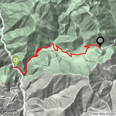
Col Saint-Martin from Rimplas climbs 16.6 km (10.3 mi) out of the Tinée valley to the La Colmiane ski station, gaining 1020 m (3348 ft) at a 6.2% average. It starts at about 497 m (1631 ft) at the junction of the M2205 and M2565 and tops out at 1515 m (4970 ft) on our profile, on the col that links the Tinée with the Vésubie valley in the Alpes-Maritimes.
The opening is the most dramatic part of the climb. The first 2 km average over 7% as the road claws up above the gorge through two short tunnels and a stretch cut into red rock, with big views back down into the Tinée. After that it settles into a steady 5-6% rhythm across the Valdeblore plateau, passing the mountain villages of La Bolline, La Roche and Saint-Dalmas, each with a fountain, before firming up again over the last 5 km into La Colmiane.
This side of the col has real racing pedigree. The Tour de France climbed the Colmiane on Stage 2 of the 2020 Grand Départ in Nice, and in 2024 the Tour's penultimate stage crossed it from the Vésubie and descended this exact road to Saint-Sauveur-sur-Tinée before the summit finish on the Col de la Couillole. Paris-Nice finished at La Colmiane in 2018, when Simon Yates won the stage. Over the top, the road drops into the Vésubie valley, which makes for an easy loop or a link to the Col de Turini.
PLAN YOUR ROUTE
 We've partnered with Sherpa-Map.com to bring you the best route planning tool. With a PRO Membership you can use this climb as a reference when creating your route.
Col Saint-Martin from Rimplas averages 6.2% over 16.6 km (10.3 mi), gaining 1020 m (3348 ft) from 497 m (1631 ft) to 1515 m (4970 ft).
The climb is steepest at both ends. The first 2 km average 7.3% and 7.1%. The middle section across the Valdeblore plateau mostly sits between 5% and 6%, with a near-flat breather at km 9 (3.2%) and a short 8.1% kilometer around La Bolline at km 10. The last 5 km firm up to 6-7%, and the final kilometer into La Colmiane is the steepest of the closing stretch at 8.3%.
The steepest 500 m averages 11.5%, the steepest kilometer 9.7%, the steepest 2 km 8.1% and the steepest 5 km 6.9%. Don't trust the roadside gradient signs on this side - riders consistently report that they don't match the road.
Roadway: The M2565 is paved the whole way and was resurfaced ahead of the 2024 Tour de France; riders since describe the surface as excellent. The first 1.6 km (1 mi) include two short tunnels, one of them unlit. Above that it is a regular two-lane mountain road through the Valdeblore villages. La Colmiane is a ski station, so expect snow and winter conditions at the top in the cold months.
Traffic: Moderate by local standards. The M2565 is the road between the Tinée and Vésubie valleys, serves the Valdeblore villages and the ski station, and is part of a Route des Grandes Alpes cycling variant, so expect local cars, motorcyclists and other cyclists in summer. Rider reports range from busy summer days to near-empty hot afternoons.
Parking: The base is a road junction near a tunnel on the valley road, with no village at the start. Most riders park in Saint-Sauveur-sur-Tinée (see our Col de la Couillole page for the town) and ride the roughly 4 km (2.5 mi) of nearly flat valley road down to the turnoff. You can also park at La Colmiane at the top, where the ski station has parking and public toilets, and ride the climb as an out-and-back from above.
Provisions: Water is easy on this side: there are fountains in La Bolline, La Roche and Saint-Dalmas, and riders report another at the col. Saint-Sauveur-sur-Tinée is the place to buy food before the start, and the Valdeblore villages are the natural spot to top up along the way.
Gear: Bring lights - at least a rear light, ideally a front one too - for the unlit tunnel in the first 1.6 km (1 mi). The finish at about 1500 m (4921 ft) is noticeably cooler than the valley floor, so carry a layer for the top and the descent, especially if you continue down the shaded Vésubie side.
Before heading out on any cycling adventure check out our Things to Bring on a Cycling Trip and use our interactive check list to ensure you don't forget anything.
Valdeblore is the reason to linger on this side of the col. Saint-Dalmas, the last village before La Colmiane, is a formerly fortified village with a town gate, vaulted passageways and a small Musée du Terroir. Its church of the Invention-de-la-Sainte-Croix, parts of which probably date to the 9th century, holds murals considered the oldest in the Alpes-Maritimes, along with a crypt and three altarpieces. Lower down in La Bolline, the church of Saint-Jacques-le-Mineur (1532) is a listed historic monument with Venetian-school paintings.
Valdeblore also runs summer activities from La Colmiane, including the beginner-friendly Baus de la Frema via ferrata and a giant zipline billed as one of the largest in France - a good rest-day option if you are based in the valley. Above the start, the perched village of Rimplas and its Maginot Line fort sit on the ridge; our Fort de Rimplas page covers the climb up to them.
Our Routes in the Area tool shows the many other climbs within reach of Valdeblore, from the Couillole to the Vésubie side, and can build a custom loop from here.
ROUTE MAP
MEMBER RATING
CURRENT WEATHER
PJAMM TRIPS ADVENTURE STARTER BUNDLES
Check out PJAMM Adventure's prepackaged (self-guided) cycling trips. They will help you plan, document and conquer your next adventure.
NEARBY CLIMBS (0) RADIAL PROXIMITY
FROM No Climbs Found
MEMBER REVIEWS & COMMENTS
Let us know what you thought of this climb. Signup for our FREE membership to write a review or post a comment.
Already have an account?
LOG IN HERE
