
22.1
PDI
8.4 mi
DISTANCE
3,285 ft
GAINED
7.3 %
AVG. GRADE
FULL CLIMB STATS
INTRO
PLAN YOUR ROUTE
 We've partnered with Sherpa-Map.com to bring you the best route planning tool. With a PRO Membership you can use this climb as a reference when creating your route.
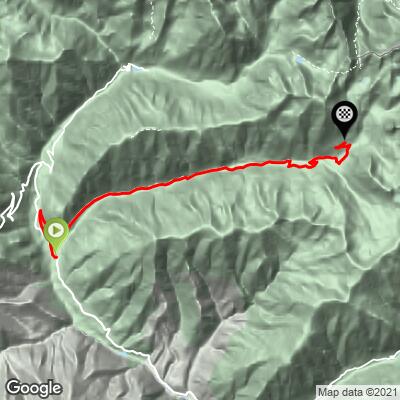
 The average grade is 7.2% over 13.5 km (8.4 mi), but the profile is uneven. The first 2 km (1.2 mi) climb gently at 5.1% and 6.9%, the third kilometer is nearly flat at 2.3%, and then the road stiffens to between 9.4% and 11.2% from km 3 to km 7 (miles 1.9 to 4.3). Expect another easing between about km 8 and km 11, followed by a final steep push at 9.2% to 9.4% before a flatter finish.
About 31.3% of the route (roughly 4.2 km, 2.6 mi) is at 10% or steeper. The steepest quarter-mile (0.4 km) averages 13.8%, the steepest mile (1.6 km) 11.6%, and the steepest kilometer (0.6 mi) 11.9%. The hardest 5 km (3.1 mi) averages 9.5%. There is one short descent of about 27 m (90 ft) along the way.
Roadway: The RM94 (Route de la Madone) is paved, but it has a recent history: Storm Alex in October 2020 opened 14 breaches in the road, swept away two structures and caused a major landslide at the first hairpin, and rebuilding has been under way ever since. The Métropole Nice Côte d'Azur currently lists the road as closed for an indefinite period (notice updated July 2026), and the FFCAM refuge lists road access from Saint-Martin-Vésubie as closed. Check the Métropole's road notices before you go.
Traffic: Minimal. The road serves only the sanctuary, the refuge and the trailheads at the road end, and access has been restricted since the storm.
Parking: Saint-Martin-Vésubie has public parking around the village, and the climb starts on Avenue Charles de Caqueray at the edge of town. There is also a small parking area beside the sanctuary at the top.
The finish is about 974 m (3,195 ft) higher than the start at 1,902 m (6,239 ft), inside a high mountain park, so carry a warm layer and a windproof for the descent. A low gear helps: with roughly a third of the route at 10% or steeper, a compact crankset with a wide cassette is the sensible choice.
There are no shops between the village and the sanctuary, so fill bottles and carry food before you start. Sections of the upper road have been stony and washed out since the storm, so tires with some volume are a good idea.
Before heading out on any cycling adventure check out our Things to Bring on a Cycling Trip and use our interactive check list to ensure you don't forget anything.
Saint-Martin-Vésubie sits at 975 m and is nicknamed La Suisse Niçoise, with medieval lanes, the Porte Sainte-Anne gate and the Rue Cagnoli. It is a natural base for a few days of riding, and our Col Saint-Martin (Vésubie) and Col de Salèse pages start from the same village. The Boréon, 8 km away at 1,500 m, is the main gateway into Mercantour National Park.
The sanctuary at the top has been a stopping point on the Nice to Piedmont route via the Col de Fenestre since the Middle Ages, and its story goes back to a Benedictine foundation in 887. The venerated statue of the Madone spends the winter in the village church; it is carried up to the sanctuary in a pilgrimage in late June and brought back down in September. A refuge run by the FFCAM stands at 1,903 m (open June 1 to September 30), and a trail from the sanctuary climbs to Lac de Fenestre at 2,266 m. To see other climbs in the area, or build a custom route from here, use our Routes in the Area tool.
ROUTE MAP
MEMBER RATING
CURRENT WEATHER
PJAMM TRIPS ADVENTURE STARTER BUNDLES
Check out PJAMM Adventure's prepackaged (self-guided) cycling trips. They will help you plan, document and conquer your next adventure.
NEARBY CLIMBS (0) RADIAL PROXIMITY
FROM No Climbs Found
MEMBER REVIEWS & COMMENTS
Let us know what you thought of this climb. Signup for our FREE membership to write a review or post a comment.
Already have an account?
LOG IN HERE
