
20.9
PDI
10.7 mi
DISTANCE
3,586 ft
GAINED
6.4 %
AVG. GRADE
FULL CLIMB STATS
INTRO
PLAN YOUR ROUTE
 We've partnered with Sherpa-Map.com to bring you the best route planning tool. With a PRO Membership you can use this climb as a reference when creating your route.
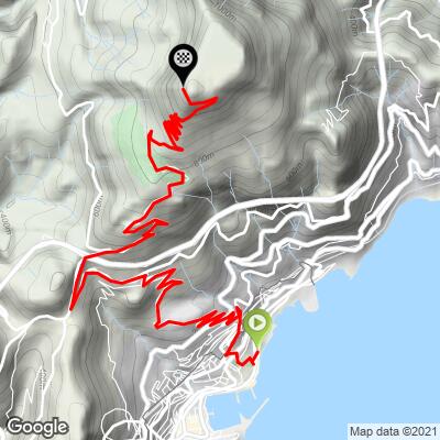
Mont Agel (Monaco) climbs 17.2 km (10.7 mi) from 17 m (56 ft) to 1110 m (3,641 ft), a gain of 1093 m (3,586 ft) at an average grade of 6.4%.
The first 9 km (5.6 mi) are the easier half, settling between 4% and 6% as the road works its way out of Monte-Carlo and up the hillside. The grade then steps up: between km 9 and km 12 it runs 7.6% to 8.7%, there is a short breather in the next kilometer at 4.9%, and the last 4 km (2.5 mi) alternate between 6% and 8%.
The steepest 100 yd (91 m) reaches 12.0%, the steepest 0.5 km (0.3 mi) averages 10.5%, and the steepest kilometer (0.6 mi) averages 10.1%. Over longer stretches, the steepest mile (1.6 km) averages 8.6%, the steepest 5 km (3.1 mi) 7.2%, and the steepest 10 km (6.2 mi) 6.7%.
Roadway: The route is paved from start to finish. It begins on city streets in Monte-Carlo and Beausoleil, then narrows to a switchbacked mountain road as it gains height behind the principality. The final stretch to the summit installations (the former Air Force base and fort) is barred to the public, so the ride finishes at a barrier near the top.
Traffic: Busy and urban for the first few kilometers through Monte-Carlo and Beausoleil, with the usual Riviera mix of cars, scooters and delivery vehicles. Once you are above the built-up area traffic thins to local residents and golfers heading to the Monte-Carlo Golf Club, and the upper road is generally quiet.
Parking: Parking is the main logistical challenge at the Monaco end: street parking in Monte-Carlo is scarce, and the paid underground car parks near the Casino are the practical choice if you drive. Arriving by train is easier - the Monaco station is underground and the start is a short, mostly uphill ride from it.
Gear: A compact crankset with a cassette of 28 teeth or larger is plenty for the 6.4% average and the 8-10% stretches in the second half. The descent is a string of tight hairpins, so check your brakes before you head back down.
Provisions: Fill your bottles in Monte-Carlo or Beausoleil before the grade steepens and carry enough for the second half. The lower slopes hold the heat, and June afternoons can be hot, so ride early in summer.
Before heading out on any cycling adventure check out our Things to Bring on a Cycling Trip and use our interactive check list to ensure you don't forget anything.
Monaco is one of the easiest places on the Riviera to start a climb without a car: regional trains run along the coast through its underground station, linking it with Nice and Menton.
The mountain is part of the principality's story. Monaco's highest point, about 160 m (525 ft), sits on Mont Agel's lower slopes along the Chemin des Révoires, and the princely family's summer residence, Roc Agel, is nearby. Higher up, the Monte-Carlo Golf Club has occupied the slopes for more than a century, and the summit holds the 1890s Fort du Mont Agel, expanded into a Maginot Line work in the 1930s, plus the former Air Base 943, which closed in 2012 and now runs automated radars.
If you are based in Monaco for a few days, the hills to the west and east hold plenty more riding - our Col de la Madone page covers the classic climb out of Menton, and you can see which other climbs start nearby with our Routes in the Area tool.
ROUTE MAP
MEMBER RATING
CURRENT WEATHER
PJAMM TRIPS ADVENTURE STARTER BUNDLES
Check out PJAMM Adventure's prepackaged (self-guided) cycling trips. They will help you plan, document and conquer your next adventure.
NEARBY CLIMBS (0) RADIAL PROXIMITY
FROM No Climbs Found
MEMBER REVIEWS & COMMENTS
Let us know what you thought of this climb. Signup for our FREE membership to write a review or post a comment.
Already have an account?
LOG IN HERE
