
18.5
PDI
9.8 mi
DISTANCE
3,207 ft
GAINED
6.2 %
AVG. GRADE
FULL CLIMB STATS
INTRO
PLAN YOUR ROUTE
 We've partnered with Sherpa-Map.com to bring you the best route planning tool. With a PRO Membership you can use this climb as a reference when creating your route.
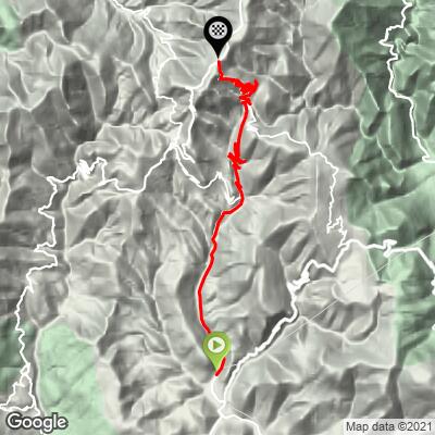
Pas de l'Escous climbs 15.8 km (9.8 mi) at a 6.2% average, gaining 977 m (3207 ft) from 387 m (1270 ft) to 1363 m (4471 ft).
The first 5 km (3.1 mi) to Lucéram are a gradual warm-up at 3-6.5%. Above the village, on the D21 hairpins, the grade settles at 6.5-7%, then builds to the steepest part of the climb, 7.8% and 8.0% for the two kilometers either side of the Col de l'Orme and the Pas de l'Escous.
There's no real break after the pass: the last 5 km (3.1 mi) to the Baisse de la Cabanette hold at 6.2-7.3%, finishing with one of the steeper stretches of the day.
Steepest 0.5 km (0.3 mi): 8.7%. Steepest 1 km (0.6 mi): 8.5%. Steepest 2 km (1.2 mi): 8.1%. Steepest 5 km (3.1 mi): 7.4%.
Roadway: Paved throughout. The D21 above Lucéram is a narrow mountain road with 26 hairpins between the village and the D2566, open all year, and riders in 2024 described it as a quiet ridge road with magnificent serpentines. The upper road near the Baisse de la Cabanette can hold snow and ice in winter, so check the Alpes-Maritimes Inforoutes06 service before an off-season ride.
Traffic: The road from L'Escarène to Lucéram carries some local traffic. Above Lucéram the D21 has practically none - a few residents, the occasional motorbike and other cyclists.
Parking: The start in L'Escarène is shared with our Baisse de la Cabannette (D2566) page, which covers the town and the train from Nice. If you only want the hairpins, Lucéram, 5.5 km (3.4 mi) up the road, makes a natural alternative start. There's nothing at the junction at the top; Peïra-Cava, a few kilometers further up the D2566, is the nearest place to stop or be picked up.
Provisions: Lucéram is the only village on the route, so refill your bottles there before the hairpins - above it the D21 has no services at all. If you're hungry at the top, continue up the D2566 to Peïra-Cava, which has mountain restaurants.
Gear: A compact chainring is plenty for grades that rarely top 8%. The finish is nearly 1000 m (3281 ft) above L'Escarène and often noticeably cooler than the coast, so bring a layer for the long, twisty descent.
Before heading out on any cycling adventure check out our Things to Bring on a Cycling Trip and use our interactive check list to ensure you don't forget anything.
L'Escarène's Salt Road history and Lucéram's churches and Christmas crèche trail are covered on our Baisse de la Cabannette (D2566) page, so this one looks higher up the mountain.
From the finish, it's a short ride up the D2566 to Peïra-Cava, a shepherds' and farmers' hamlet that became a military observation post facing Italy at the end of the 19th century and then a winter playground for Nice's high society, with luge, skating and ski jumping. It's the oldest cross-country ski resort in the Alpes-Maritimes, and its mountain restaurants are known for blueberry tart. At the entrance to the village, a short, well-marked walk leads to Pierre Plate, a stone orientation table looking over the southern Alps to the Mediterranean and, on the clearest days, Corsica.
Beyond Peïra-Cava the road continues to the Col de Turini - see our Col de Turini (La Bollène) page for its rally history - or you can loop back down to Lucéram via the Col Saint-Roch.
ROUTE MAP
MEMBER RATING
CURRENT WEATHER
PJAMM TRIPS ADVENTURE STARTER BUNDLES
Check out PJAMM Adventure's prepackaged (self-guided) cycling trips. They will help you plan, document and conquer your next adventure.
NEARBY CLIMBS (0) RADIAL PROXIMITY
FROM No Climbs Found
MEMBER REVIEWS & COMMENTS
Let us know what you thought of this climb. Signup for our FREE membership to write a review or post a comment.
Already have an account?
LOG IN HERE
