
20.1
PDI
10.7 mi
DISTANCE
3,548 ft
GAINED
5.9 %
AVG. GRADE
FULL CLIMB STATS
INTRO
PLAN YOUR ROUTE
 We've partnered with Sherpa-Map.com to bring you the best route planning tool. With a PRO Membership you can use this climb as a reference when creating your route.
The average grade is 5.9% over 17.2 km (10.7 mi), rising from 373 m (1,225 ft) to 1,377 m (4,519 ft), with a high point of 1,394 m (4,573 ft) just beyond. The steepest 0.5 km (0.3 mi) averages 14.3%, the steepest kilometer (0.6 mi) 10.8%, the steepest 5 km (3.1 mi) 8.8% and the steepest 10 km (6.2 mi) 7.2%. The hardest single pitch, about 100 yards (91 m), reaches 21.9%.
The gentle valley miles from L'Escarène to Lucéram pull the overall average down; once the hairpins begin the grade is well above it, and the climb is best paced as a warm-up followed by a long, steady effort.
Roadway: The road is paved throughout, from the Montée de la Gare in L'Escarène through the Route de Lucéram and the Route du Col Saint-Roch onto the D2566. Riders describe the pavement as excellent, and the hairpins above Lucéram are widely considered spectacular and photogenic. The upper road can see snow in winter.
Traffic: Light. Cyclists report very little traffic, with the occasional sports car and motorbike enjoying the hairpins.
Parking: L'Escarène is a small town of roughly 2,600 residents in the Paillon valley, and the climb starts on the Montée de la Gare, the road up from the railway station, so riders arriving by train can roll straight onto it. Lucéram, 8 km (5.0 mi) up the road, is the first real village on the route.
Provisions: Lucéram, 8 km (5.0 mi) from the start, is the last village before the climb gets serious, so plan to refill bottles there. Beyond it the road is forested and quiet.
Gear: A compact chainring and a 30-tooth or larger sprocket suit the hairpins above the Pas de l'Escous, where short pitches climb well above 10%. The descent is fast and twisty, so bring a light layer; the upper road is cooler than the coast.
Before heading out on any cycling adventure check out our Things to Bring on a Cycling Trip and use our interactive check list to ensure you don't forget anything.
L'Escarène was a main stop on the old Salt Road between Provence and Piedmont, and it still has the Church of Saint-Pierre-ès-Liens, with a listed organ built by the Grinda brothers in 1791, the old bridge and an oil mill museum. It is also on the Nice to Breil-sur-Roya railway, which opened in 1928, so the start is reachable from Nice without a car (check current bike carriage rules before you travel).
Lucéram is worth a proper stop: a fortified hill village at about 650 m (2,133 ft), with a church of Sainte-Marguerite-et-Rosalie built in 1487 and five altarpieces, one of them dated 1510 and attributed to Louis Bréa. In December and January the village hosts a nativity crèche circuit of over 500 scenes. A wildfire in 2003 burned more than 2,000 hectares around the Col Saint-Roch and the village was narrowly saved.
For another taste of rally country, see our Col de Turini (Sospel) page. To see other climbs nearby, including the Col de Braus and the Pas de l'Escous, try our Routes in the Area tool.
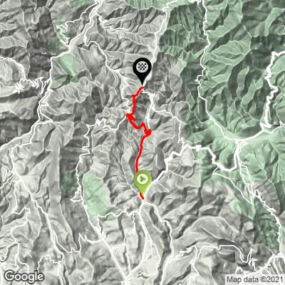
ROUTE MAP
MEMBER RATING
CURRENT WEATHER
PJAMM TRIPS ADVENTURE STARTER BUNDLES
Check out PJAMM Adventure's prepackaged (self-guided) cycling trips. They will help you plan, document and conquer your next adventure.
NEARBY CLIMBS (0) RADIAL PROXIMITY
FROM No Climbs Found
MEMBER REVIEWS & COMMENTS
Let us know what you thought of this climb. Signup for our FREE membership to write a review or post a comment.
Already have an account?
LOG IN HERE
