
17.1
PDI
12.7 mi
DISTANCE
3,506 ft
GAINED
4.5 %
AVG. GRADE
FULL CLIMB STATS
INTRO
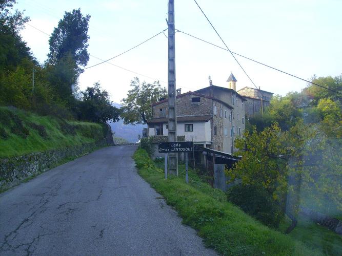
Loda is the kind of place you only ever see from a bike: a few stone houses, the church of Saint-Arnoux and what's left of a 13th-century castle, hanging on the slope above the Vésubie about 4 km out of Lantosque. It's the first landmark on this long, quiet way to the Baisse de la Cabannette, which crosses the Col de la Porte before it ever touches the D2566. In all it's 20.5 km (12.7 mi) with 1069 m (3506 ft) of climbing, and two downhill stretches along the way.
The first 5 km are easy, around 4% on a single-lane road cut into the hillside, with stone retaining walls on one side and the valley on the other. Past Loda the road drops for almost 2 km to the Pont de l'Infernet, and that's where the climbing starts properly: about 7 km at 6 to 7.5% through the woods on a narrower road, up to the Col de la Porte at 1057 m. From there you coast 2 km down to the Col Saint-Roch (990 m), turn onto the wider D2566 and climb the last 4.6 km at 8.1%, with the steepest kilometer at 10.4% in the hairpins near the top.
Riders who've done the Col de la Porte from this side mostly say the same things: hardly any cars, plenty of shade in the morning, and a harder middle section than the profile suggests. The finish at 1364 m is a saddle in the forest rather than a summit with a view, but Peïra-Cava is a few kilometers further on, and the Col de Turini beyond that if you want to keep going.
PLAN YOUR ROUTE
 We've partnered with Sherpa-Map.com to bring you the best route planning tool. With a PRO Membership you can use this climb as a reference when creating your route.
From 443 m (1456 ft) in Lantosque to 1364 m (4476 ft) at the saddle, the climb gains 1069 m (3506 ft) over 20.5 km (12.7 mi), with about 148 m of downhill mixed in. The steepest kilometer averages 10.4%, the steepest 2 km 9.7% and the steepest 5 km 7.4%.
Km 0-5: 3.9% on the Route de Loda, an easy spin above the valley to Loda.
Km 5-6.9: Downhill, losing about 50 m to the Pont de l'Infernet.
Km 6.9-13.7: 6.9% on a narrow, irregular road through the woods to the Col de la Porte (1057 m).
Km 13.7-15.8: Descent of about 65 m to the Col Saint-Roch (990 m) and the D2566.
Km 15.8-20.4: 8.1% up the D2566 hairpins to the Baisse de la Cabannette, the steepest kilometer coming about 2 km from the top.
Roadway: Paved throughout. The first 16 km, on the Route de Loda over the Col de la Porte, are single-lane, with stone walls, guardrails on the drop side and blind bends; the asphalt is decent but patched and gritty in places, so ride the corners like there's a car coming. From the Col Saint-Roch the D2566 is a proper two-lane road with a center line and a better surface. The upper road can see snow in winter.
Traffic: Very light on the Col de la Porte road, which mostly serves Loda and a few scattered houses. The D2566 is busier, since it links Lucéram, Peïra-Cava and the Col de Turini, and you'll meet the odd motorbike or sports car enjoying the hairpins, but it's still a quiet road.
Parking: Lantosque is built on a rocky spur above the M2565, and the old village has very little room. Look for a legal space along the main valley road near the start rather than driving into the center, and keep clear of the narrow lanes and the Route de Loda itself.
Gear: A compact with a 28 or 30 handles the Col de la Porte; save something lower for the D2566, where the hairpins near the top go past 10%. The middle section is shaded in the morning but this is still Côte d'Azur back country, so start early in summer. Bring a layer for the top - you finish above 1300 m and the descent runs through cool forest.
Provisions: Fill bottles and buy what you need in Lantosque before you turn for Loda. After that the route passes only small hamlets and forest until the finish.
Before heading out on any cycling adventure check out our Things to Bring on a Cycling Trip and use our interactive check list to ensure you don't forget anything.
Lantosque is a hill village of about 1200 people on the main road up the Vésubie valley from Nice. It has a via ferrata along the gorge wall with suspension bridges, a big village fountain from 1866, and a chestnut festival in October.
The fun is in what you do from the top. Carry on past Peïra-Cava to the Col de Turini, descend to La Bollène-Vésubie and roll back down the valley to Lantosque, and you've made a big loop on the rally roads - our Col de Turini (La Bollène) page covers that side. Or drop down the D2566 hairpins to Lucéram, a fortified hill village with a 15th-century church, which our Baisse de la Cabannette (D2566) page climbs from L'Escarène.
To see how the Lantosque, Lucéram and Turini climbs fit together, open Routes in the Area on this page.
ROUTE MAP

MEMBER RATING
CURRENT WEATHER
PJAMM TRIPS ADVENTURE STARTER BUNDLES
Check out PJAMM Adventure's prepackaged (self-guided) cycling trips. They will help you plan, document and conquer your next adventure.
NEARBY CLIMBS (0) RADIAL PROXIMITY
FROM No Climbs Found
MEMBER REVIEWS & COMMENTS
Let us know what you thought of this climb. Signup for our FREE membership to write a review or post a comment.
Already have an account?
LOG IN HERE
