Sitgreaves Pass West Bike Climb - PJAMM Cycling

4.5
PDI
4.5 mi
DISTANCE
1,034 ft
GAINED
3.8 %
AVG. GRADE

FULL CLIMB STATS

Page Contributor(s): Dan Razum, Campbell, CA, USA

INTRO

This 4.5 mile bike climb is located in AZ, USA. The average gradient is 3.8% and there is a total elevation gain of 1,034 ft, finishing at 3,491 ft.

Use the profile tool, route map, and weather forecast to conquer this cycling climb.

See more details and tools regarding this climb's grade via our interactive Profile Tool.
Information Not Available

If you have any information regarding this climb, we'd like to hear from you. Click the CONTRIBUTE button to share your thoughts with us.

Information Not Available

If you have any information regarding this climb, we'd like to hear from you. Click the CONTRIBUTE button to share your thoughts with us.

Before heading out on any cycling adventure check out our Things to Bring on a Cycling Trip and use our interactive check list to ensure you don't forget anything.
Information Not Available

If you have any information regarding this climb, we'd like to hear from you. Click the CONTRIBUTE button to share your thoughts with us.

ROUTE MAP

MEMBER RATING

Not Yet Rated
-
Road
-
Traffic
-
Scenery

CURRENT WEATHER

PJAMM TRIPS ADVENTURE STARTER BUNDLES

Check out PJAMM Adventure's prepackaged (self-guided) cycling trips. They will help you plan, document and conquer your next adventure.
ALL TRIPS
Browse all of our prepackaged trips and find your next adventure!
Arizona: Cycling and Spring Training
United States (AZ)
17 ROUTES
48 POIs
ROUTE STATS (TOTAL)
360.3
mi
DISTANCE
33,516
ft
ELEV. GAIN
Arizona: Mt. Lemmon
United States (AZ)
11 ROUTES
28 POIs
ROUTE STATS (TOTAL)
62.4
mi
DISTANCE
16,765
ft
ELEV. GAIN
The American Southwest
United States (AZ,NM,UT)
18 ROUTES
27 POIs
ROUTE STATS (TOTAL)
215.4
mi
DISTANCE
34,866
ft
ELEV. GAIN

NEARBY CLIMBS (0) RADIAL PROXIMITY

FROM
No Climbs Found

MEMBER REVIEWS & COMMENTS

Let us know what you thought of this climb. Signup for our FREE membership to write a review or post a comment.
Already have an account?
ROUTE MAP
PROFILE TOOL
Route Data
S.G. (%)
hide
Segment Data
hide

Climb Profile Not Found
CLIMB SUMMARY

Cycling Sitgreaves Pass West

Ride 4.5 miles gaining 1,038’ at 3.8% average grade (5.4% climb only)

Climb summary and photos by PJAMM ambassador Dan Razum, Campbell, CA.

For Sitgreaves Pass West we start the climb in the town of Oatman, AZ. Technically, the road

slopes upwards all the way from Topock, over 20 miles away, but the meat of the climb is from Oatman

up to the pass, so we chose Oatman as our starting point.  

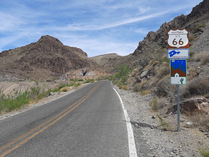
Oatman is a small touristy town and well worth a visit to see the charm and scenery of old historic Route 66. This climb is on one of the few remaining original sections of Route 66.  So if you're a cyclist and you want to get your kicks then

do this climb on Route 66!

You will most likely encounter wild donkeys or mules in Oatman, although they are actually pretty

tame since they are accustomed to people and free food from tourists. However, be aware that the

donkeys can roam far and wide so be careful in sharp turns, as you may come across some donkeys

standing in the road.

The climb starts out gently and even has a short downhill section in the first part.  Then we approach

a mine and the gradient kicks up a bit which means that the steepest part of the climb is the

second half. And of course there isn't any shade and things tend to heat up in the desert, so bring

plenty of water.  Luckily, the climb isn't too long so the heat doesn't have a chance to wear you

down too much.

Sitgreave Pass from the west has steeper sections than from the east but the scenery is a little

better on the eastern side. However, both sides are well worth doing for the thrill of riding old

Route 66.  

Thank you Dan!!