

20.7
PDI
8.8 mi
DISTANCE
3,266 ft
GAINED
7 %
AVG. GRADE
FULL CLIMB STATS
Page Contributor(s): Lisa Irizarry and Matt Jiang, NY, NY
INTRO
Col de la Sinne climbs 14.2 km (8.8 mi) from the Tinée valley floor to a 1,437 m (4,713 ft) col in the Alpes-Maritimes, gaining 995 m (3,266 ft) at a 7.0% average grade. It is one of the quietest big climbs in the Nice hinterland: the D59 starts just after the bridge over the Tinée, winds through oak woodland, and climbs to the perched medieval village of Ilonse before breaking out onto open slopes with long views over Marie, Clans and the Tinée valley toward the Mercantour.
The grade is steady rather than savage. The steepest kilometer averages 10.2% and the steepest 100 yards touch 14.8%, but most of the climb sits around 7-8% with no real rest, and rider reports through June 2026 describe almost no cars. Above Ilonse the road narrows and the shade disappears completely, so the upper half is a sun-exposed grind.
At the top there is a fountain, benches and walking-trail maps - the col is also the trailhead for the hike up the Lauvet d'Ilonse. Our Col de la Sinne (Pierlas) page covers the other approach, which comes up from the Gorges du Cians.
PLAN YOUR ROUTE
 We've partnered with Sherpa-Map.com to bring you the best route planning tool. With a PRO Membership you can use this climb as a reference when creating your route.
Col de la Sinne gains 995 m (3,266 ft) over 14.2 km (8.8 mi), rising from 441 m (1,448 ft) in the Tinée valley to 1,437 m (4,713 ft) at the col, for a 7.0% average grade.
The steepest mile averages 9.6%, the steepest kilometer 10.2%, and the steepest half kilometer 11.1%, with the steepest 100 yards reaching 14.8%. Over longer stretches the numbers settle down: the steepest 5 km average 8.1% and the steepest 10 km average 7.4%.
In practice that means a firm start of 7-8% or more, a long steady middle with very few flat sections to recover on, and a slightly easier final approach to the col.
Roadway: The road is paved the entire way. It was resurfaced in 2012 and riders described the surface as excellent afterward; more recent reports say the road narrows above Ilonse and the pavement is rougher there, but still rideable. The descent toward the Gorges du Cians side is twisty, with frequent changes of gradient and loose gravel on the road, so take it slowly if you drop that way.
Traffic: Very light. A rider in June 2026 reported almost no cars on the whole climb, and earlier reports describe riding it alone. Most of what you will meet is local traffic around Ilonse.
Parking: The start is a valley-floor junction rather than a village, so the practical option is to park in Saint-Sauveur-sur-Tinée, a few kilometers up the valley, where there is parking near the village center and along the river, and ride down the valley road to the base of the climb. The col has a small picnic and rest area with a fountain.
Provisions: Water is the main concern. There is a fountain in Ilonse that riders use as a stop, and another at the col, but the stretch above Ilonse is long and fully exposed, so leave the village with full bottles rather than counting on the next top-up. On a hot afternoon one rider recommended keeping a reserve because Ilonse is not the end of the climb.
Gear: There is essentially no shade from roughly halfway up, so sun protection matters in summer; starting early avoids the worst of it. The sustained 7-8% grade rewards a comfortable gearing choice. If you descend the Cians side, expect gravel in the corners and keep your tires and brakes in good shape.
Before heading out on any cycling adventure check out our Things to Bring on a Cycling Trip and use our interactive check list to ensure you don't forget anything.
Ilonse is the highlight of the route and worth a short stop. The village is built in steps on a steep rocky outcrop under Mont Cocouluche, and a rider once described it as an eagle's nest. It is a classified medieval village with a 13th-century church, Saint-Michel, at the top (its paintings are listed as historic monuments), covered arcaded wash houses, and a small square with a panoramic terrace. It is also the usual place to refill bottles.
From the col you can walk to the Lauvet d'Ilonse, a 13.5 km (8.4 mi) hike that takes roughly 5 hours 45 minutes and is rated hard, with a 360 degree view of the Mercantour from the top - a good rest-day option if you are staying in the valley. Nice is about 70 km (43.5 mi) away by road.
For a bigger day, one rider logged a loop of about 95 km (59 mi): up through Ilonse to the col, down into the Cians valley, then Villars-sur-Var, Massoins and back to Pont de Clans. Saint-Sauveur-sur-Tinée, just up the valley, is also the start of the Col de la Couillole, which our Col de la Couillole page covers in detail (including Roubion and the summit auberge). To see the other climbs around the Tinée valley, or build a custom route from here, try our Routes in the Area tool.
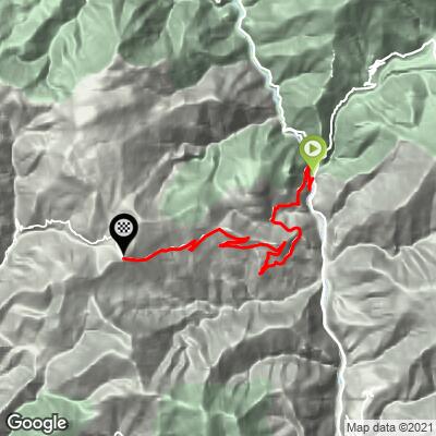
ROUTE MAP
MEMBER RATING
CURRENT WEATHER
PJAMM TRIPS ADVENTURE STARTER BUNDLES
Check out PJAMM Adventure's prepackaged (self-guided) cycling trips. They will help you plan, document and conquer your next adventure.
NEARBY CLIMBS (0) RADIAL PROXIMITY
FROM No Climbs Found
MEMBER REVIEWS & COMMENTS
Let us know what you thought of this climb. Signup for our FREE membership to write a review or post a comment.
Already have an account?
LOG IN HERE
