

18.5
PDI
9.2 mi
DISTANCE
3,084 ft
GAINED
6.3 %
AVG. GRADE
FULL CLIMB STATS
Page Contributor(s): Lisa Irizarry and Mathew Jiang, NY, NY
INTRO
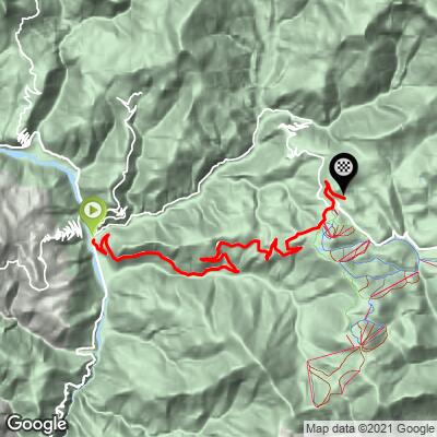
Valberg climbs 14.7 km (9.1 mi) from Guillaumes, in the upper Var valley, over the Col de Valberg and into the ski resort of Valberg, finishing at 1724 m (5655 ft). It gains 940 m (3084 ft) at a 6.3% average and is currently ranked #1156 in the world in our database.
The real work is all in the first 12 km (7.5 mi), which climb from Guillaumes to the col at about 7.3% with almost no relief - riders describe it as very regular, with no flat sections to recover on. The hairpins begin right at the edge of Guillaumes, and the D28, part of the Route des Grandes Alpes, is wide, well built and smoothly surfaced. From the belvedere at the Col de Valberg (about 1670 m / 5479 ft) you look back down over Guillaumes and the Tuébi valley, and the last 2.7 km (1.7 mi) roll gently through the resort to the finish.
Valberg, founded in 1936, is the oldest mountain resort in the Alpes-Maritimes, and the surrounding Alpes d'Azur Mercantour territory was designated an International Dark Sky Reserve in 2019. From the resort the D28 carries on to Beuil, where roads lead over the Col de la Couillole or down the Gorges du Cians, so this climb links easily into some of the best riding in the region.
PLAN YOUR ROUTE
 We've partnered with Sherpa-Map.com to bring you the best route planning tool. With a PRO Membership you can use this climb as a reference when creating your route.
Valberg climbs 14.7 km (9.1 mi) at a 6.3% average, gaining 940 m (3084 ft) from 794 m (2605 ft) to 1724 m (5655 ft).
That average undersells it. The first 12 km (7.5 mi), from Guillaumes to the Col de Valberg, average about 7.3%, and every one of those kilometers sits between 6.1% and 8.6%. The hardest stretch is between 4 km (2.5 mi) and 6 km (3.7 mi), where consecutive kilometers average 8.1% and 8.6%.
Past the col, the final 2.7 km (1.7 mi) through the resort average only about 2%, an easy spin to the finish.
Steepest 0.5 km (0.3 mi): 9.3%. Steepest 1 km (0.6 mi): 8.9%. Steepest 2 km (1.2 mi): 8.5%. Steepest 5 km (3.1 mi): 7.8%.
Roadway: The D28 from Guillaumes is wide, well built and paved the whole way, and riders consistently describe the surface as excellent. It's the road up to a ski resort at around 1700 m (5577 ft), so expect snow and ice on the upper section from late autumn into spring and check the Alpes-Maritimes Inforoutes06 service before an off-season ride.
Traffic: Moderate in summer, when the Route des Grandes Alpes brings tourists, motorcyclists and other cyclists, and riders flag the traffic on the Gorges de Daluis side of Guillaumes in particular. Outside the holidays it can be very quiet - riders in October 2024 reported hardly any traffic. For a quieter, more scenic alternative, see our Valberg (Péone) climb on the D29.
Parking: Guillaumes is a small village at the head of the Gorges de Daluis, and the climb starts on the Avenue de Valberg at its edge, so park in the village and roll straight onto the hairpins. At the top, Valberg is a full resort village around a large central square, which makes it an easy place to meet a ride or stop for lunch.
Provisions: Stock up in Guillaumes, which has bakeries in the village - there's nothing between the village and the col. Valberg has a bakery, restaurants and bars, plus bike inflation and repair stations and e-bike charging points.
Gear: A compact chainring with a 28- or 30-tooth cog suits 12 km (7.5 mi) of steady 7-8% grades. Riders warn the climb gets hot on summer afternoons, so start early and carry two bottles, and bring a layer for the descent from 1700 m (5577 ft).
Before heading out on any cycling adventure check out our Things to Bring on a Cycling Trip and use our interactive check list to ensure you don't forget anything.
Guillaumes repays a wander before you roll out. The ruins of its castle, known as the Château de la Reine Jeanne, with a round tower and a rectangular residence, stand above the village, and the 13th-century Église Saint-Étienne has a Romanesque-Lombard bell tower. Just downstream, the Var has carved the red-rock Gorges de Daluis more than 300 m (984 ft) deep, and the Pont de la Mariée, a 58 m (190 ft) span built for the old Haut-Var tramway, spans the gorge.
Up top, Valberg's Notre-Dame-des-Neiges church, blessed in 1948, with steep larch roofs and a porch fresco by Jean Cassarini, is a striking piece of postwar mountain architecture. On summer nights the resort makes the most of its dark skies, with astronomy events and a planet-themed walking trail through the village.
The Gorges du Cians and the Couillole are covered on our Col de la Couillole page, and Saint-Martin-d'Entraunes, up the Var, on our Col de la Cayolle page. To see other climbs around Guillaumes, including Valberg via Péone, Sauze and Bouchanières, or build a custom route from here, try our Routes in the Area tool.
ROUTE MAP
MEMBER RATING
CURRENT WEATHER
PJAMM TRIPS ADVENTURE STARTER BUNDLES
Check out PJAMM Adventure's prepackaged (self-guided) cycling trips. They will help you plan, document and conquer your next adventure.
NEARBY CLIMBS (0) RADIAL PROXIMITY
FROM No Climbs Found
MEMBER REVIEWS & COMMENTS
Let us know what you thought of this climb. Signup for our FREE membership to write a review or post a comment.
Already have an account?
LOG IN HERE
