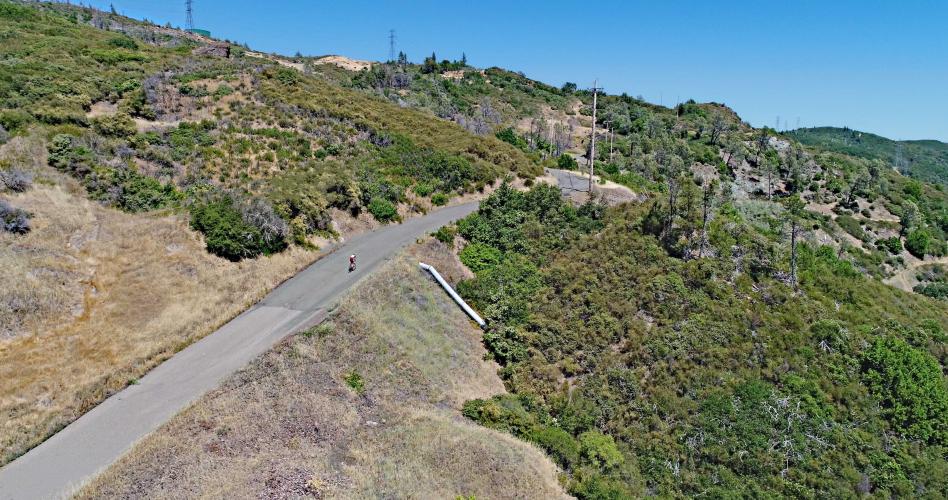
![Pine Flat Road Climbing Pine Flat Road by bike - aerial drone photo of roadway, hillside, mountains and vineyards.]()
Cycling Pine Flat Road -- Sonoma County’s fourth most difficult bike climb.
Ride 11.2 miles to 3,158’ gaining 3,589’ at 4.9% average grade.
Before heading to wine country on your cycling adventure, be sure to rely on our list of Things to Bring on a Cycling Trip, and use our interactive checklist to ensure you don't forget anything.
Climb summary by PJAMM’s John Johnson.
![]()
![Pine Flat Road - start Bike ride up Pine Flat Road - aerial drone photo of start and vineyards]()
Looking back from the start via drone aerial photo.
Pine Flat is located in the Mayacamas Mountains, which stretch 52 miles from Clear Lake in Lake County, to northern Sonoma and Napa counties.
![Pine Flat Road - lower section Climbing Pine Flat Road by bike - cyclist on road]()
First stretch of Pine Flat Road.
![Pine Flat Road - The Wall]()
Lower portion of the climb.
![Pine Flat Road - The Wall Biking up Pine Flat Road - cyclist on the wall, roadway]()
Aerial drone panorama of mile three to finish.
The first seven miles of Pine Flat (to “the guardrail” as the locals refer to it) are a modest ascent at 5.5% average grade, followed by 2.1 miles that actually averages -0.8% grade (perhaps where the "flat" part of the road's name comes from).
![]()
![]()
“The Guardrail”
Spot on mile seven.
![]()
Two Pine “Flat” miles after the guardrail.
The biggest challenge of this climb comes toward the end, with the last 2.2 miles averaging 9.2%, with 1.1 mile at the beginning of that stretch averaging 11.4% (20% for a brief time on "The Wall" at the 10.1 mile mark.) The upper portion of the ride approaches The Geysers area and can be torturously hot in the summer.
![]()
Read it and weep -- the Garmin don’t lie!
Peak gradient on “The Wall”.
![]()
“The Wall” -- ¼ mile at 16% beginning at mile 10.2.
![]()
One of the hardest stretches of road in Sonoma County.
![Pine Flat Road - near the top Bicycle climb of Pine Flat Road - cyclist on the roadway on bikes with road and power lines]()
Section just after The Wall.
![]()
Pine Flat in spring.
Roadway Surface and Traffic Report: The roadway is in decent condition at the bottom, with moderate deterioration towards the top. Caution is required for the decent, as the upper portion of the mountain is very steep with rough road, sharp turns and gravel in many locations. Traffic over the entire climb is minimal.
A LITTLE HISTORY
![]()
Old structure at the start of the climb.
There were hundreds of mercury (“quicksilver”) permits drawn in the 1870s, and many active mines operating in Sonoma County in the late 19th and early 20th centuries. The last mine to close was the Mount Jackson Mercury Mine, located in the Sonoma County town of Guerneville on Sweetwater Springs Road, which operated from 1889 to 1972. The largest mining town was Pine Flat, which grew up around the mercury mine in that area. (Santa Rosa Press Democrat, July 11, 2010 “The Lasting Impact of Mercury”) and in its hay day consisted of 60 homes, three hotels, two dry goods stores, a fruit vendor, bakery, lumber yard, two shoe shops, two laundries and six saloons -- no churches or schools, however! The structure pictured above may be related to the Pine Flat mining town, although the original town was located three to four miles up Pine Flat Road, and there are no obvious signs of the town remaining.
![]()
Photos in this section are from the Pressdemocrat’s article titled Boomtown’s Bust,
written by Clark Mason and published December 11, 2014.
Photo courtesy of Healdsburg Museum.
![]()
![]()
In the 1870s, Pine Flat may have been the fastest growing town in Northern California, born of the mercury boom during that time. Pine Flat’s population in the 1870s is estimated at 1,000-4,000. Seventy claims were filed in this area, known as Cinnabar Mining District, with colorful names such as Fandango, Mohawk, Socrates, and Rattlesnake. The Press Democrat’s article Boomtown’s Bust, by Clark Mason, is quite entertaining and a good read for those interested in Sonoma County History.
![]()
That’s a wrap!!

 We've partnered with Sherpa-Map.com to bring you the best route planning tool. With a PRO Membership you can use this climb as a reference when creating your route.


