
21.1
PDI
11.8 mi
DISTANCE
3,673 ft
GAINED
5.9 %
AVG. GRADE
FULL CLIMB STATS
INTRO
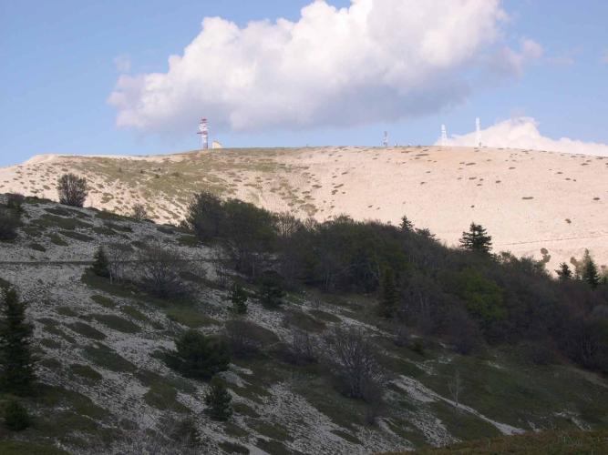
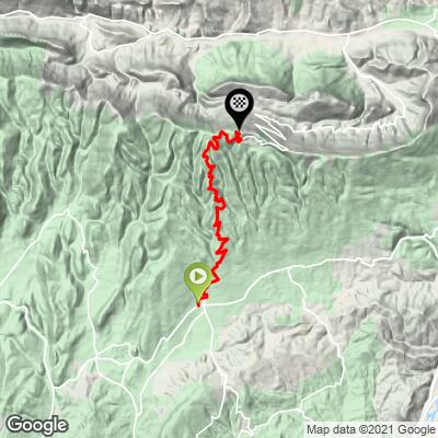
Signal de Lure from Saint-Étienne-les-Orgues climbs 19.0 km (11.8 mi) and 1,120 m (3,673 ft) at an average grade of 5.9%, from the village at 689 m (2,259 ft) to the bare summit ridge of the Montagne de Lure at 1,808 m (5,931 ft), just below the 1,826 m (5,991 ft) high point. It ranks #886 on our list of the world's hardest climbs.
This is a long, even climb rather than a punishing one. After a first kilometer at about 6%, the road settles into forest at 5-7%, with the steepest kilometer, around the 12 km (7.5 mi) mark, reaching 10.0%. Near the top the forest gives way to open, pale limestone slopes, the grade eases to 1-4% for the last few kilometers, and on a clear day the view reaches toward Mont Ventoux and the Alps. Along the way you pass the Station de Lure, a small mountain station at 1,600 m (5,249 ft).
Traffic is light, and the mountain has a real following among riders: it has twice hosted Paris-Nice stages, and on Monday mornings in July and August the road from the village to the summit has been reserved for cyclists. For the quieter north side, see our Signal de Lure (Les Tournières) page.
PLAN YOUR ROUTE
 We've partnered with Sherpa-Map.com to bring you the best route planning tool. With a PRO Membership you can use this climb as a reference when creating your route.
 Signal de Lure averages 5.9% over 19.0 km (11.8 mi), gaining 1,120 m (3,673 ft). The effort is remarkably even: most kilometers fall between 5% and 7%, with a slightly harder run of about 7% from roughly 9 to 11 km (5.6 to 6.8 mi).
The steepest 0.5 km (0.3 mi) averages 15.5%, the steepest 1 km (0.6 mi) 10.0%, the steepest 2 km (1.2 mi) 8.7%, the steepest 5 km (3.1 mi) 7.5% and the steepest 10 km (6.2 mi) 6.6%. Past about 16 km (9.9 mi) the grade eases to 1-4%, so the final stretch to the ridge is more a rolling cruise than a climb, with a short, sharper rise right at the end. Save something for the 12 km (7.5 mi) mark, where the steepest kilometer arrives.
Roadway: The road is paved from the village to the summit ridge, with a mix of smooth and coarse asphalt, and riders note it becomes rough in the final kilometers; the last stretch to the 1,826 m (5,991 ft) high point is an unpaved track. Snow and ice can affect the upper road outside summer, so check conditions before riding in winter or early spring. Take care on the descent, especially through the rough upper kilometers.
Traffic: Light. Cars are mostly visitors heading to the Station de Lure and walkers using the ridge. On Monday mornings in July and August the road from Saint-Étienne-les-Orgues to the summit has been reserved for cyclists, typically from 8 am to noon, and the dates change each year, so confirm them with the local tourist office before you plan around them.
Parking: Saint-Étienne-les-Orgues (687 m / 2,254 ft) is a village of about 1,300 residents, so parking means courteous street or village-square parking; keep driveways and entrances clear. Our start sits on the edge of the village, so you can ride straight out.
Provisions: Fill your bottles in the village before you start. Food and drink are available at La Sauvagine, a cafe at the Lure refuge around 15 km (9.3 mi) up, and the Station de Lure (1,600 m / 5,249 ft) has a restaurant and a gîte d'étape, but opening times are seasonal, so carry enough to reach the top.
Gear: The upper climb is open and exposed, and the top is noticeably cooler and windier than the village, so pack a windproof layer for the descent. A compact crankset is plenty for an average of 5.9%, and wider tires are welcome on the rough asphalt near the top.
Before heading out on any cycling adventure check out our Things to Bring on a Cycling Trip and use our interactive check list to ensure you don't forget anything.
Saint-Étienne-les-Orgues sits at 687 m (2,254 ft), about 10 km (6.2 mi) north of Forcalquier, the larger town for lodging and supplies. The village's 15th- and 16th-century church has ribbed vaulting and is worth a look before you ride.
On the mountain, the Abbaye de Notre-Dame de Lure, rebuilt between 1637 and 1659, and the Marc Bianchi observatory are both listed among the attractions around the Station de Lure, which also has a restaurant and dormitory lodging for riders who want to stay up high. Local organizers also run a Strava challenge on the climb that awards gold, silver or bronze diplomas by time.
Other Lure climbs start from different valleys: the north side from Les Tournières is covered on our Signal de Lure (Les Tournières) page, and you can see other climbs nearby, or build a custom route from here, with our Routes in the Area tool.
ROUTE MAP
MEMBER RATING
CURRENT WEATHER
PJAMM TRIPS ADVENTURE STARTER BUNDLES
Check out PJAMM Adventure's prepackaged (self-guided) cycling trips. They will help you plan, document and conquer your next adventure.
NEARBY CLIMBS (0) RADIAL PROXIMITY
FROM No Climbs Found
MEMBER REVIEWS & COMMENTS
Let us know what you thought of this climb. Signup for our FREE membership to write a review or post a comment.
Already have an account?
LOG IN HERE
MethowBiker
I was fortunate to do this while the road was still blocked at the summit to prevent further northbound traffic. My friends and bike shop folks in Manosque highly recommended this over Ventoux, as you don’t have the “motards” , as the French refer to them (you’ll see signs in towns too, they are tired of high speed moto groups), on this route.
Terrific views to the Alps north, towards Grenoble. Food in Saint Étienne, though there’s a cafe at the ski station at 1580 mètres, which was also open the Sunday I did the climb. Don’t count on it though.
